Jigsaw Puzzle > Fine Art Storehouse > Map
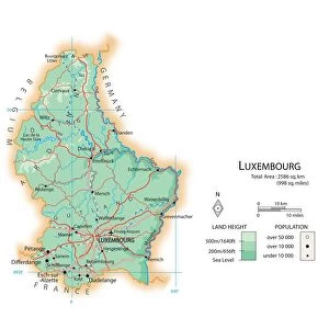
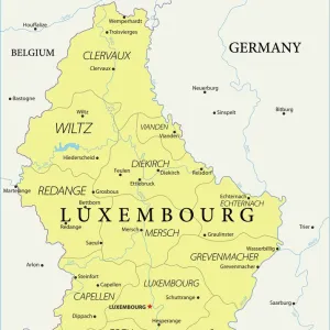
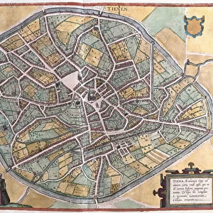
Jigsaw Puzzle : Belgium and Luxembourg, lithograph, published in 1874


![]()
Jigsaw Puzzles from Fine Art Storehouse
Belgium and Luxembourg, lithograph, published in 1874
Antique map of Belgium and Luxembourg. Lithograph, published in 1874
Unleash your creativity and transform your space into a visual masterpiece!
Media ID 13666711
© ZU_09
Atlantic Ocean Belgium Benelux Contour Drawing Country Geographic Area Ethnocultural History Land Luxembourg Benelux Topographic Map Topography
Jigsaw Puzzle (500 Pieces)
Step back in time with Media Storehouse's exquisite antique jigsaw puzzle of Belgium and Luxembourg, a stunning lithograph published in 1874. This intricately detailed puzzle features an elegant map of the regions, capturing the historical charm of Europe in a bygone era. Immerse yourself in the rich history and culture of this beautiful part of the world as you piece together this stunning work of art. Perfect for puzzle enthusiasts and history buffs alike, this antique map puzzle is a must-have addition to any collection. Engage your mind and transport yourself to another time with Media Storehouse's Belgium and Luxembourg puzzle.
500 piece puzzles are custom made in Australia and hand-finished on 100% recycled 1.6mm thick laminated puzzle boards. There is a level of repetition in jigsaw shapes with each matching piece away from its pair. The completed puzzle measures 40x51cm and is delivered packaged in an attractive presentation box specially designed to fit most mail slots with a unique magnetic lid
Jigsaw Puzzles are an ideal gift for any occasion
Estimated Product Size is 50.7cm x 40.3cm (20" x 15.9")
These are individually made so all sizes are approximate
Artwork printed orientated as per the preview above, with landscape (horizontal) or portrait (vertical) orientation to match the source image.
FEATURES IN THESE COLLECTIONS
> Fine Art Storehouse
> Map
> Historical Maps
EDITORS COMMENTS
This lithograph, published in 1874, showcases the ethnocultural and geographic history of Belgium and Luxembourg. The antique map takes us on a journey through time, offering a glimpse into the topography and land formations of these European countries. The horizontal composition allows for a comprehensive view of the region, stretching from the Atlantic Ocean to Luxembourg's capital city, Paris. With no people depicted in this contour drawing, our focus is solely on the intricate details presented by the cartographer. The artist's meticulous attention to detail is evident as they skillfully engraved each line and curve onto stone before printing it onto paper using lithography techniques. This method not only captures every nuance but also adds depth to the image. As we explore this historical artifact further, we are transported back to an era when maps were essential tools for navigation and exploration. The topographic map provides invaluable information about elevation changes and natural features that would have guided travelers during that time. Whether you're an avid collector or simply appreciate art with historical significance, this print offers a unique opportunity to own a piece of history. Its timeless beauty serves as a reminder of how far cartography has come while honoring its rich heritage.
MADE IN AUSTRALIA
Safe Shipping with 30 Day Money Back Guarantee
FREE PERSONALISATION*
We are proud to offer a range of customisation features including Personalised Captions, Color Filters and Picture Zoom Tools
SECURE PAYMENTS
We happily accept a wide range of payment options so you can pay for the things you need in the way that is most convenient for you
* Options may vary by product and licensing agreement. Zoomed Pictures can be adjusted in the Cart.