Jigsaw Puzzle > Europe > France > Canton > Landes
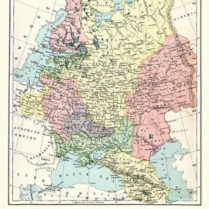
Jigsaw Puzzle : Map of Alsace-Lorraine, lithograph, published in 1875


![]()
Jigsaw Puzzles from Fine Art Storehouse
Map of Alsace-Lorraine, lithograph, published in 1875
Ancient map of Alsace-Lorraine (German: Elsass-Lothringen). Lithograph, published in 1875
Unleash your creativity and transform your space into a visual masterpiece!
Media ID 13666731
© ZU_09
Alsace Contour Drawing Country Geographic Area French Culture German Culture Land Lorraine Strasbourg Topographic Map Topography Obsolete
Jigsaw Puzzle (500 Pieces)
Discover the rich history of Alsace-Lorraine with our exquisite jigsaw puzzle from Media Storehouse. This intricately detailed puzzle features an ancient map of the region, originally published as a lithograph in 1875. Immerse yourself in the beauty of this Fine Art Storehouse print as you piece together the borders, cities, and rivers that once shaped the cultural tapestry of Alsace-Lorraine. A captivating puzzle for history buffs, geography enthusiasts, and anyone seeking a challenging and rewarding puzzle experience.
500 piece puzzles are custom made in Australia and hand-finished on 100% recycled 1.6mm thick laminated puzzle boards. There is a level of repetition in jigsaw shapes with each matching piece away from its pair. The completed puzzle measures 40x51cm and is delivered packaged in an attractive presentation box specially designed to fit most mail slots with a unique magnetic lid
Jigsaw Puzzles are an ideal gift for any occasion
Estimated Product Size is 40.3cm x 50.7cm (15.9" x 20")
These are individually made so all sizes are approximate
Artwork printed orientated as per the preview above, with landscape (horizontal) or portrait (vertical) orientation to match the source image.
FEATURES IN THESE COLLECTIONS
> Fine Art Storehouse
> Map
> Historical Maps
> Europe
> France
> Canton
> Landes
> Europe
> France
> Strasbourg
> Europe
> Germany
> Related Images
> Maps and Charts
> Early Maps
> Maps and Charts
> Related Images
EDITORS COMMENTS
This lithograph, published in 1875, showcases the ancient map of Alsace-Lorraine (German: Elsass-Lothringen). Steeped in history and cultural significance, this antique print offers a glimpse into a bygone era. The meticulously engraved image captures the topography and intricate details of this region, which has witnessed the confluence of German and French cultures throughout centuries. As one's eyes trace the contour lines on this vertical composition, it becomes evident that this map is more than just a representation of land. It serves as a testament to the complex historical narrative that unfolded within these borders. From Strasbourg to Alsace, from Germany to France, each stroke tells stories of shifting alliances and territorial disputes. The faded hues evoke nostalgia for times long past while reminding us of the enduring legacy left behind by both German and French influences. This lithograph transports us back to an age when Alsace-Lorraine was at the center stage of European politics. With no people present in this photograph taken in 2015, we are reminded that time marches on relentlessly. Yet through artful preservation like this lithograph print, we can still appreciate and study our rich heritage. Let it serve as a reminder not only of geographical boundaries but also as an invitation to explore how culture shapes our understanding of history itself.
MADE IN AUSTRALIA
Safe Shipping with 30 Day Money Back Guarantee
FREE PERSONALISATION*
We are proud to offer a range of customisation features including Personalised Captions, Color Filters and Picture Zoom Tools
SECURE PAYMENTS
We happily accept a wide range of payment options so you can pay for the things you need in the way that is most convenient for you
* Options may vary by product and licensing agreement. Zoomed Pictures can be adjusted in the Cart.