Jigsaw Puzzle > Europe > France > Canton > Landes
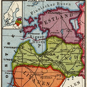
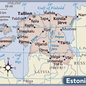
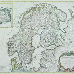
Jigsaw Puzzle : Map of Baltic states, lithograph, published in 1877


![]()
Jigsaw Puzzles from Fine Art Storehouse
Map of Baltic states, lithograph, published in 1877
Historic map of Baltic states: Lithuania, Estonia, Latvia. Lithograph, published in 1877
Unleash your creativity and transform your space into a visual masterpiece!
Media ID 13666751
© ZU_09
78279 Baltic Countries Baltic Sea Contour Drawing Country Geographic Area Estonia European Culture Finland Image Date Island Land Latvia Lithuania Riga Topographic Map Topography Gulf Of Finland Image Created 19th Century
Jigsaw Puzzle (500 Pieces)
Step back in time with our exquisite jigsaw puzzle from the Media Storehouse Map of Baltic States collection. This intricately detailed puzzle features a historic lithograph of the Baltic region, published in 1877. Featuring the beautiful and historic countries of Lithuania, Estonia, and Latvia, this puzzle is a must-have for history enthusiasts and puzzle lovers alike. The high-quality pieces fit seamlessly together, providing hours of enjoyable and rewarding puzzle-solving experience. Bring a piece of history into your home with this stunning and captivating puzzle.
500 piece puzzles are custom made in Australia and hand-finished on 100% recycled 1.6mm thick laminated puzzle boards. There is a level of repetition in jigsaw shapes with each matching piece away from its pair. The completed puzzle measures 40x51cm and is delivered packaged in an attractive presentation box specially designed to fit most mail slots with a unique magnetic lid
Jigsaw Puzzles are an ideal gift for any occasion
Estimated Product Size is 40.3cm x 50.7cm (15.9" x 20")
These are individually made so all sizes are approximate
Artwork printed orientated as per the preview above, with landscape (horizontal) or portrait (vertical) orientation to match the source image.
FEATURES IN THESE COLLECTIONS
> Fine Art Storehouse
> Map
> Historical Maps
> Europe
> Estonia
> Related Images
> Europe
> Finland
> Related Images
> Europe
> France
> Canton
> Landes
> Europe
> Latvia
> Related Images
EDITORS COMMENTS
This lithograph, published in 1877, showcases a historic map of the Baltic states - Lithuania, Estonia, and Latvia. A true testament to European culture and cartography of the time, this antique engraved image offers a glimpse into the topography and land formations of these countries nestled along the Baltic Sea. The intricate details highlight key features such as the Gulf of Finland and Riga, while also encompassing smaller islands within this region. With its vertical composition and contour drawing style, this lithograph exudes an air of ancient history. Its creation in the 19th century adds to its allure as a valuable piece that captures not only geographical information but also reflects upon cultural significance. Each country's unique identity is subtly represented through symbols associated with Lithuanian, Latvian, and Estonian cultures. As we gaze at this remarkable print from 1877 - preserved beautifully even in modern times - it serves as a visual portal to explore the past. It reminds us of how these Baltic countries have evolved over time while retaining their distinct characteristics. This map holds immense historical value for scholars studying European geography or those seeking insight into bygone eras.
MADE IN AUSTRALIA
Safe Shipping with 30 Day Money Back Guarantee
FREE PERSONALISATION*
We are proud to offer a range of customisation features including Personalised Captions, Color Filters and Picture Zoom Tools
SECURE PAYMENTS
We happily accept a wide range of payment options so you can pay for the things you need in the way that is most convenient for you
* Options may vary by product and licensing agreement. Zoomed Pictures can be adjusted in the Cart.