Jigsaw Puzzle > Maps and Charts > Americas
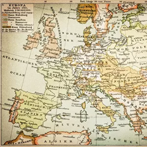
Jigsaw Puzzle : Map of Europe 18811889


![]()
Jigsaw Puzzles from Fine Art Storehouse
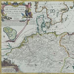
Map of Europe 18811889
Comprehensive Geography by James Monteith - American Book Company 1882, 1889
Unleash your creativity and transform your space into a visual masterpiece!
THEPALMER
Media ID 18357315
Jigsaw Puzzle (500 Pieces)
Discover the rich history of geography with the Media Storehouse Map of Europe 1881-1889 jigsaw puzzle, featuring an intricately detailed image of Europe as it appeared during the late 19th century. This puzzle, sourced from the Fine Art Storehouse collection, is based on a map from Comprehensive Geography by James Monteith published by the American Book Company in 1882 and 1889. Assemble this captivating puzzle to transport yourself back in time and expand your knowledge of European geography. A perfect activity for history enthusiasts, families, or anyone seeking a challenging and educational puzzle experience.
500 piece puzzles are custom made in Australia and hand-finished on 100% recycled 1.6mm thick laminated puzzle boards. There is a level of repetition in jigsaw shapes with each matching piece away from its pair. The completed puzzle measures 40x51cm and is delivered packaged in an attractive presentation box specially designed to fit most mail slots with a unique magnetic lid
Jigsaw Puzzles are an ideal gift for any occasion
Estimated Product Size is 50.7cm x 40.3cm (20" x 15.9")
These are individually made so all sizes are approximate
Artwork printed orientated as per the preview above, with landscape (horizontal) or portrait (vertical) orientation to match the source image.
FEATURES IN THESE COLLECTIONS
> Fine Art Storehouse
> Map
> Historical Maps
> Europe
> Related Images
> Maps and Charts
> Related Images
EDITORS COMMENTS
This print titled "Map of Europe 1881-1889" takes us on a journey back in time, offering a glimpse into the intricate world of cartography during the late 19th century. The map, originally featured in James Monteith's renowned book "Comprehensive Geography" was published by the American Book Company in both 1882 and 1889. With its meticulous detail and artistic flair, this vintage map transports us to an era where exploration and discovery were at their peak. Each country is delicately outlined, showcasing borders that have evolved over time due to political shifts and historical events. From the vast Russian Empire stretching across Eastern Europe to the fragmented Austro-Hungarian Empire nestled amidst diverse cultures, this map encapsulates a Europe on the brink of change. The sepia tones add an air of nostalgia to this piece, enhancing its timeless appeal. As we examine each intricately labeled city and region, we are reminded of how geography shapes our understanding of history. This particular print from Fine Art Storehouse allows us to appreciate not only the artistry behind old-world maps but also serves as a reminder that knowledge has always been cherished throughout human history. "The Map of Europe 1881-1889" by THEPALMER invites us to explore our past through cartographic lenses while simultaneously appreciating it as a work of art. It sparks curiosity about how our modern world has evolved since then while reminding us that even in today's digital age, there is still something
MADE IN AUSTRALIA
Safe Shipping with 30 Day Money Back Guarantee
FREE PERSONALISATION*
We are proud to offer a range of customisation features including Personalised Captions, Color Filters and Picture Zoom Tools
SECURE PAYMENTS
We happily accept a wide range of payment options so you can pay for the things you need in the way that is most convenient for you
* Options may vary by product and licensing agreement. Zoomed Pictures can be adjusted in the Cart.