Jigsaw Puzzle > Europe > Related Images
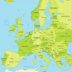
Jigsaw Puzzle : Map of Europe 1900


![]()
Jigsaw Puzzles from Fine Art Storehouse
Map of Europe 1900
Meyers hand-Atlas Leipzig und Wien Verlag des Bibliographischen Instituts 1900
Unleash your creativity and transform your space into a visual masterpiece!
THEPALMER
Media ID 18106875
© 2014 Roberto Adrian Photography
Jigsaw Puzzle (500 Pieces)
Discover the rich history of Europe with our captivating jigsaw puzzle from Media Storehouse's Fine Art Storehouse collection. The intricately detailed Map of Europe 1900 by THEPALMER, based on the original map from Meyers Hand-Atlas Leipzig und Wien Verlag des Bibliographischen Instituts 1900, invites you on an educational and engaging journey. Piece together the diverse landscapes, borders, and territories that shaped Europe's past. This premium puzzle, with its high-quality, thick, and durable pieces, offers hours of enjoyable assembly for puzzle enthusiasts of all ages. Travel back in time and expand your geographical knowledge with this captivating puzzle.
500 piece puzzles are custom made in Australia and hand-finished on 100% recycled 1.6mm thick laminated puzzle boards. There is a level of repetition in jigsaw shapes with each matching piece away from its pair. The completed puzzle measures 40x51cm and is delivered packaged in an attractive presentation box specially designed to fit most mail slots with a unique magnetic lid
Jigsaw Puzzles are an ideal gift for any occasion
Estimated Product Size is 50.7cm x 40.3cm (20" x 15.9")
These are individually made so all sizes are approximate
Artwork printed orientated as per the preview above, with landscape (horizontal) or portrait (vertical) orientation to match the source image.
FEATURES IN THESE COLLECTIONS
> Fine Art Storehouse
> Map
> Historical Maps
> Europe
> Related Images
EDITORS COMMENTS
In this print titled "Map of Europe 1900". THEPALMER takes us on a journey back in time to the turn of the 20th century. The image showcases an exquisite piece from Meyers hand-Atlas Leipzig und Wien Verlag des Bibliographischen Instituts, originally published in 1900. The map itself is a true testament to the artistry and precision that went into cartography during that era. With intricate details and delicate lines, it beautifully captures the political boundaries, cities, rivers, and mountain ranges of Europe as they were known over a century ago. As we gaze upon this vintage masterpiece, we are transported to a different world - one where empires still reigned supreme and borders held different meanings. It serves as a reminder of how history has shaped our present-day geopolitical landscape. Beyond its historical significance, this print also stands out for its aesthetic appeal. The muted colors evoke a sense of nostalgia while adding an air of elegance to any space it graces. Whether displayed in homes or offices, it effortlessly becomes both an educational tool and an eye-catching work of art. "The Map of Europe 1900" by THEPALMER offers us not only a glimpse into the past but also invites us to appreciate the beauty found within historical artifacts. It serves as a timeless reminder that even in our fast-paced digital age, there is immense value in preserving tangible pieces that connect us with our collective heritage.
MADE IN AUSTRALIA
Safe Shipping with 30 Day Money Back Guarantee
FREE PERSONALISATION*
We are proud to offer a range of customisation features including Personalised Captions, Color Filters and Picture Zoom Tools
SECURE PAYMENTS
We happily accept a wide range of payment options so you can pay for the things you need in the way that is most convenient for you
* Options may vary by product and licensing agreement. Zoomed Pictures can be adjusted in the Cart.