Jigsaw Puzzle > Arts > Artists > B > Willem Blaeu
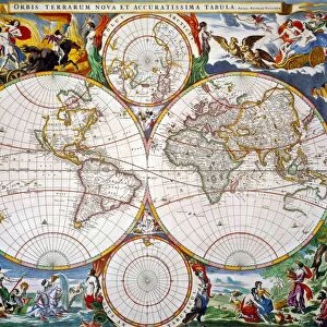
Jigsaw Puzzle : Map of Groningen, Netherlands, 17th century


![]()
Jigsaw Puzzles from Heritage Images
Map of Groningen, Netherlands, 17th century
Map of Groningen, Netherlands, 17th century. A map of the Dutch province of Groningen, published by Willem Blaeu after the original design by Barthold Wicheringe
Heritage Images features heritage image collections
Media ID 14947077
© Print Collector / Heritage-Images
Blaeu Cartography Map Making North Sea Print Collector9 Willem Blaeu Barthold Groningen
Jigsaw Puzzle (500 Pieces)
Discover the rich history of Groningen, Netherlands with our exquisite jigsaw puzzle from Media Storehouse. This intricately detailed puzzle features a captivating 17th-century map of the Dutch province of Groningen, published by Willem Blaeu from an original design by Barthold Wicheringe. Bring the past to life as you piece together this beautiful and intricate puzzle, showcasing the intricate cartography and historical landmarks of the region. A perfect gift for history enthusiasts or anyone who loves a challenging puzzle.
500 piece puzzles are custom made in Australia and hand-finished on 100% recycled 1.6mm thick laminated puzzle boards. There is a level of repetition in jigsaw shapes with each matching piece away from its pair. The completed puzzle measures 40x51cm and is delivered packaged in an attractive presentation box specially designed to fit most mail slots with a unique magnetic lid
Jigsaw Puzzles are an ideal gift for any occasion
Estimated Product Size is 50.7cm x 40.3cm (20" x 15.9")
These are individually made so all sizes are approximate
Artwork printed orientated as per the preview above, with landscape (horizontal) or portrait (vertical) orientation to match the source image.
FEATURES IN THESE COLLECTIONS
> Arts
> Artists
> B
> Willem Blaeu
> Europe
> Netherlands
> Groningen
> Europe
> Netherlands
> Maps
> Europe
> Netherlands
> Posters
> Europe
> Netherlands
> Related Images
> Maps and Charts
> Netherlands
> Maps and Charts
> Related Images
> Maps and Charts
> Willem Janszoon Blaeu
EDITORS COMMENTS
This print showcases a remarkable piece of cartography from the 17th century - the Map of Groningen, Netherlands. Created by Barthold Wicheringe and later published by Willem Blaeu, this map provides an intriguing glimpse into the geography and coastal features of the Dutch province. The intricate details on this map transport us back in time to a period when map-making was both an art form and a scientific endeavor. With its precise delineation of boundaries, waterways, and towns, it offers valuable insights into the country's historical landscape. As we explore this print further, our eyes are drawn to the North Sea coast that borders Groningen. The strategic location of this province made it a significant hub for trade and maritime activities during that era. The craftsmanship evident in this print is truly awe-inspiring. Each stroke meticulously captures every geographical feature with utmost precision. It serves as a testament to the skillful collaboration between Wicheringe and Blaeu, two renowned figures in cartographic history. Preserved through time by The Print Collector, this image allows us to appreciate not only its aesthetic beauty but also its invaluable contribution to our understanding of Groningen's past. Let us marvel at how these ancient maps continue to connect us with our ancestors' journeys across land and sea while reminding us of their enduring legacy in shaping our world today.
MADE IN AUSTRALIA
Safe Shipping with 30 Day Money Back Guarantee
FREE PERSONALISATION*
We are proud to offer a range of customisation features including Personalised Captions, Color Filters and Picture Zoom Tools
SECURE PAYMENTS
We happily accept a wide range of payment options so you can pay for the things you need in the way that is most convenient for you
* Options may vary by product and licensing agreement. Zoomed Pictures can be adjusted in the Cart.