Jigsaw Puzzle > Universal Images Group (UIG) > Universal Images Group > Satellite and Aerial > Planet Observer 4
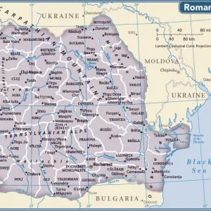
Jigsaw Puzzle : Ukraine, Relief Map with Border and Mask


![]()
Jigsaw Puzzles from Universal Images Group (UIG)
Ukraine, Relief Map with Border and Mask
Relief map of Ukraine (with border and mask). This image was compiled from data acquired by landsat 5 & 7 satellites combined with elevation data
Universal Images Group (UIG) manages distribution for many leading specialist agencies worldwide
Media ID 9613461
© Planet Observer/UIG
Black Sea Carpathian Mountains Coastline Crimea Danube River Kiev Mountain Mountain Range Relief Map Shore Snow Ukraine Kyiv Odesa Satellite View
Jigsaw Puzzle (500 Pieces)
Discover the intricacies of Ukrainian geography with our exquisite jigsaw puzzle from Media Storehouse. Featuring a stunning relief map of Ukraine, this puzzle comes with an added layer of detail - a border and mask. Compiled from data acquired by Landsat 5 & 7 satellites, this puzzle showcases the beautiful and complex terrain of Ukraine in a whole new way. Challenge yourself and your family with this educational and engaging puzzle that promises hours of fun and learning.
500 piece puzzles are custom made in Australia and hand-finished on 100% recycled 1.6mm thick laminated puzzle boards. There is a level of repetition in jigsaw shapes with each matching piece away from its pair. The completed puzzle measures 40x51cm and is delivered packaged in an attractive presentation box specially designed to fit most mail slots with a unique magnetic lid
Jigsaw Puzzles are an ideal gift for any occasion
Estimated Product Size is 50.7cm x 40.3cm (20" x 15.9")
These are individually made so all sizes are approximate
Artwork printed orientated as per the preview above, with landscape (horizontal) or portrait (vertical) orientation to match the source image.
EDITORS COMMENTS
This print showcases the intricate and diverse topography of Ukraine, a country nestled in Eastern Europe. The relief map, created using data acquired by Landsat 5 & 7 satellites combined with elevation data, offers a stunning visual representation of Ukraine's physical geography. The image captures the majestic Carpathian Mountains dominating the western part of the country, their snow-capped peaks standing tall against the clear blue sky. As our eyes wander eastward, we are drawn to the mesmerizing coastline along the Black Sea. The shoreline is beautifully depicted, revealing both sandy beaches and rocky cliffs that meet with crashing waves. Intriguingly, this relief map also includes Crimea—a region that has been at the center of geopolitical tensions in recent years—highlighting its unique geographical features. Further exploration reveals other notable landmarks such as Kiev (also known as Kyiv), Ukraine's capital city situated on both sides of the Dnieper River; Odesa, a bustling port city on the Black Sea coast; and even glimpses of Danube River meandering through Ukrainian territory. With no people visible in this photograph, it allows us to solely focus on appreciating Ukraine's natural beauty from an aerial perspective. This horizontal composition presents an artistic blend of colors and textures that make it not only informative but also visually captivating for those fascinated by cartography or simply intrigued by exploring new landscapes.
MADE IN AUSTRALIA
Safe Shipping with 30 Day Money Back Guarantee
FREE PERSONALISATION*
We are proud to offer a range of customisation features including Personalised Captions, Color Filters and Picture Zoom Tools
SECURE PAYMENTS
We happily accept a wide range of payment options so you can pay for the things you need in the way that is most convenient for you
* Options may vary by product and licensing agreement. Zoomed Pictures can be adjusted in the Cart.