Home > Asia > Afghanistan > Maps
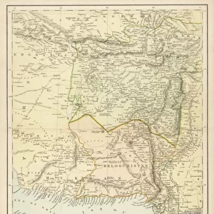
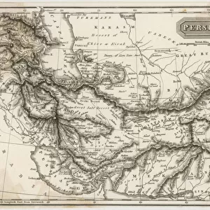
Iran Persia Map 1876 Gotha, Justus Perthes, Atlas

![]()
Wall Art and Photo Gifts from Liszt Collection
Iran Persia Map 1876 Gotha, Justus Perthes, Atlas
Iran Persia Map 1876 Gotha, Justus Perthes, Atlas. Perthes, Johan Georg Justus 1749 aa 1816, German publisher, was born in Rudolstadt in 1749. In 1785 he founded at Gotha the business which bears his name, Justus Perthes. In this he was joined in 1814 by his son Wilhelm, 1793 aa 1853. He laid the foundation of the Geographical Branch of the business, for which it is chiefly famous, by publishing the and-Atlas (1817-1823) of Adolf Stieler (1775-1836). Wilhelm Perthes engaged the collaboration of the most eminent German geographers of the time, including Heinrich Berghaus, Christian Gottlieb Reichard, Karl Spruler and Emil von Sydow. The business passed to his son Bernard Wilhelm Perthes (1821-1857). In 1863 the firm first issued the Almanach de Gotha, a statistical, Historical and genealogical Annual (in French) of the various countries of the world
Liszt Collection of nineteenth-century engravings and images to browse and enjoy
Media ID 12958933
© Quint Lox Limited
Afghanistan Allemagne Book Of Maps Bundesrepublik Deutschland D Allemagne D,allemagne Deutschland Erfurt Gotha Justus Perthes Liszt Collection Republica Federal De Alemania Thuringia Atlas Perse Turan Turkestan
FEATURES IN THESE COLLECTIONS
> Asia
> Afghanistan
> Maps
> Liszt Collection
> Engravings
> Maps and Charts
> Early Maps
> Maps and Charts
> World
EDITORS COMMENTS
This print showcases the "Iran Persia Map 1876 Gotha, Justus Perthes, Atlas" from the Liszt Collection. The map was published by Johan Georg Justus Perthes in 1876 and offers a fascinating glimpse into the historical geography of Iran and its neighboring regions. Justus Perthes, a renowned German publisher born in Rudolstadt in 1749, founded his business in Gotha in 1785. His son Wilhelm joined him in 1814 and played a pivotal role in establishing the Geographical Branch of their publishing house. Together with esteemed German geographers like Heinrich Berghaus and Karl Spruler, they collaborated on significant projects such as Adolf Stieler's And-Atlas (1817-1823). The Almanach de Gotha, first issued by the firm in 1863, became another notable publication that provided statistical, historical, and genealogical information about various countries worldwide. This vintage print not only represents an important piece of cartographic history but also reflects the artistic techniques prevalent during that era. The engraving technique used to create this image adds a touch of elegance to its Victorian aesthetic. As part of the Liszt Collection's vast archive of historical prints and engravings, this photograph serves as a valuable resource for those interested in exploring Iran's past geopolitical landscape. It is an evocative reminder of how maps have played an essential role throughout history by providing knowledge and understanding about different regions around the world.
MADE IN AUSTRALIA
Safe Shipping with 30 Day Money Back Guarantee
FREE PERSONALISATION*
We are proud to offer a range of customisation features including Personalised Captions, Color Filters and Picture Zoom Tools
SECURE PAYMENTS
We happily accept a wide range of payment options so you can pay for the things you need in the way that is most convenient for you
* Options may vary by product and licensing agreement. Zoomed Pictures can be adjusted in the Cart.