Fraud Blocker Skip to main content

Home > Maps and Charts > Georgia

Georgia Collection (page 6)

Georgia is a state located in the southeastern region of the United States

366 items

Background imageGeorgia Collection: Town Plan of Savannah, c. 1733 (pen & ink on paper)

Town Plan of Savannah, c. 1733 (pen & ink on paper)
3964034 Town Plan of Savannah, c.1733 (pen & ink on paper) by American School, (18th century); 35.2x39.5 cm; By kind permission of the Earl of Leicester and the Trustees of the Holkham Estate;

Background imageGeorgia Collection: Holkham MS 109 F 41, plans of the city and harbour of New York, c. 1740 (engraving)

Holkham MS 109 F 41, plans of the city and harbour of New York, c. 1740 (engraving)
3963912 Holkham MS 109 F 41, plans of the city and harbour of New York, c.1740 (engraving) by Carwitham, John (1700-60); 30x44 cm; By kind permission of the Earl of Leicester

Background imageGeorgia Collection: Page 33 The Island of South Georgia, 1768-75 (w / c)

Page 33 The Island of South Georgia, 1768-75 (w / c)
5670298 Page 33 The Island of South Georgia, 1768-75 (w/c) by Hodges, William (1744-97); Mitchell Library, State Library of New South Wales; (add.info.: Original Sketches, Drawings)

Background imageGeorgia Collection: Map of the Parish or Borough of Leeds, 1781 (engraving)

Map of the Parish or Borough of Leeds, 1781 (engraving)
5977045 Map of the Parish or Borough of Leeds, 1781 (engraving) by English School, (19th century); 140.5x141 cm; Leeds Museums and Art Galleries (Abbey House Museum) UK; (add.info)

Background imageGeorgia Collection: Asian Turkey, including Antolia, Georgia, Armenia, Kurdestan, Diarbec, Irak-Arabi, Syria

Asian Turkey, including Antolia, Georgia, Armenia, Kurdestan, Diarbec, Irak-Arabi, Syria, engraving by G
3572580 Asian Turkey, including Antolia, Georgia, Armenia, Kurdestan, Diarbec, Irak-Arabi, Syria, engraving by G. Zuliani taken from Tome IV of the " Newest Atlas" published in Venice in

Background imageGeorgia Collection: Map of the eastern hemisphere, illustration from A journal of a voyage to the South

Map of the eastern hemisphere, illustration from A journal of a voyage to the South
3610754 Map of the eastern hemisphere, illustration from A journal of a voyage to the South Seas : in His Majestys ship, the Endeavour, 1794 (hand-coloured engraving) by Parkinson

Background imageGeorgia Collection: Map of the western hemisphere, illustration from A journal of a voyage to the South

Map of the western hemisphere, illustration from A journal of a voyage to the South
3610752 Map of the western hemisphere, illustration from A journal of a voyage to the South Seas : in His Majestys ship, the Endeavour, 1794 (hand-coloured engraving) by Parkinson

Background imageGeorgia Collection: Group portrait of Frederick, Prince of Wales, with his brother the Duke of Cumberland

Group portrait of Frederick, Prince of Wales, with his brother the Duke of Cumberland
CTS336300 Group portrait of Frederick, Prince of Wales, with his brother the Duke of Cumberland and their five sisters, 1730 (oil on canvas) by Aikman

Background imageGeorgia Collection: The Environs of Savannah (engraving)

The Environs of Savannah (engraving)
1610082 The Environs of Savannah (engraving) by Dower, John (fl.c.1845-55); Private Collection; (add.info.: The Environs of Savannah. Illustration for The Illustrated London News, 14 January 1865)

Background imageGeorgia Collection: A View of Savannah as it stood on the 29th March 1734, engraved by P

A View of Savannah as it stood on the 29th March 1734, engraved by P
3964033 A View of Savannah as it stood on the 29th March 1734, engraved by P. Fourdrinier, London, c.1735 (engraving) by Gordon

Background imageGeorgia Collection: The Grand Signior retiring, pub. 1796 (hand coloured engraving)

The Grand Signior retiring, pub. 1796 (hand coloured engraving)
3035672 The Grand Signior retiring, pub. 1796 (hand coloured engraving) by Gillray, James (1757-1815); Private Collection; (add.info.: George)

Background imageGeorgia Collection: Map of the Seat of War, made in Savannah, Georgia, 1861 (litho)

Map of the Seat of War, made in Savannah, Georgia, 1861 (litho)
696120 Map of the Seat of War, made in Savannah, Georgia, 1861 (litho) by Grant, M. B. (fl.1861); 47.5x60.5 cm; Gilder Lehrman Collection, New York, USA; (add.info.: Compiled and drawn by M. B)

Background imageGeorgia Collection: Manuscript Civil War map of General Shermans Atlanta campaign, c. 1864 (litho)

Manuscript Civil War map of General Shermans Atlanta campaign, c. 1864 (litho)
696117 Manuscript Civil War map of General Shermans Atlanta campaign, c.1864 (litho) by Stevens, Asbury L. (1843-c.1890) and Snell, J.P

Background imageGeorgia Collection: Illustration from The Imperial Guide with Picturesque Plans of the Great Post

Illustration from The Imperial Guide with Picturesque Plans of the Great Post
XYC258620 Illustration from The Imperial Guide with Picturesque Plans of the Great Post Roads, 1802 (hand-coloured engraving) by Baker

Background imageGeorgia Collection: Portrait of a Midshipman (oil on canvas)

Portrait of a Midshipman (oil on canvas)
LCF223136 Portrait of a Midshipman (oil on canvas) by Chamberlain, Mason (1727-87); 134.6x106 cm; Trustees of Leeds Castle Foundation, Maidstone, Kent, UK; English, out of copyright

Background imageGeorgia Collection: The Grand-Signior Retiring, published by Hannah Humphrey in 1796 (hand-coloured etching)

The Grand-Signior Retiring, published by Hannah Humphrey in 1796 (hand-coloured etching)
NCO193152 The Grand-Signior Retiring, published by Hannah Humphrey in 1796 (hand-coloured etching) by Gillray, James (1757-1815); Courtesy of the Warden and Scholars of New College

Background imageGeorgia Collection: Map of the Arabian Peninsula, with wind rose and details of ports and sea coasts

Map of the Arabian Peninsula, with wind rose and details of ports and sea coasts
AIS5334416 Map of the Arabian Peninsula, with wind rose and details of ports and sea coasts, in Atlas de Joan Martines, 1587 (manuscript) by Martines, Joan (1556-1590); Biblioteca Nacional, Madrid

Background imageGeorgia Collection: Map illustrating General Shermans March through Georgia from Atlanta to Savannah

Map illustrating General Shermans March through Georgia from Atlanta to Savannah
1610097 Map illustrating General Shermans March through Georgia from Atlanta to Savannah, November and December 1864 (engraving) by Dower

Background imageGeorgia Collection: Powder horn, engraved with a map of the St. Lawrence River in the area of Quebec, c

Powder horn, engraved with a map of the St. Lawrence River in the area of Quebec, c
997377 Powder horn, engraved with a map of the St. Lawrence River in the area of Quebec, c.1759 (horn) (see also 997378-80) by Canadian School

Background imageGeorgia Collection: Plan of the Siege of Savannah, 1796. Creator: Charles Balthazar Julien Fé

Plan of the Siege of Savannah, 1796. Creator: Charles Balthazar Julien Fé
Plan of the Siege of Savannah, 1796

Background imageGeorgia Collection: German officer (a Georgian) explaining details of a military map to US officers from

German officer (a Georgian) explaining details of a military map to US officers from the Allied Expeditionary Force which made the initial landings in Northern France. WW2

Background imageGeorgia Collection: German officer (a Georgian) explaining details of a military map to US officers from

German officer (a Georgian) explaining details of a military map to US officers from the Allied Expeditionary Force which made the initial landings in Northern France. WW2 June 6 1944

Background imageGeorgia Collection: USA South Eastern states map 1877

USA South Eastern states map 1877
USA South Eastern states map - Florida, North Carolina, South Carolina, Georgia, Alabama, Tennessee (1877)

Background imageGeorgia Collection: Wakefield WF5 0 Map

Wakefield WF5 0 Map
Postcode Sector Map of Wakefield WF5 0

Background imageGeorgia Collection: East Riding of Yorkshire YO15 3 Map

East Riding of Yorkshire YO15 3 Map
Postcode Sector Map of East Riding of Yorkshire YO15 3

Background imageGeorgia Collection: Warrington WA5 8 Map

Warrington WA5 8 Map
Postcode Sector Map of Warrington WA5 8

Background imageGeorgia Collection: Cornwall TR20 8 Map

Cornwall TR20 8 Map
Postcode Sector Map of Cornwall TR20 8

Background imageGeorgia Collection: Hastings TN38 0 Map

Hastings TN38 0 Map
Postcode Sector Map of Hastings TN38 0

Background imageGeorgia Collection: Rother TN40 2 Map

Rother TN40 2 Map
Postcode Sector Map of Rother TN40 2

Background imageGeorgia Collection: Spelthorne TW18 4 Map

Spelthorne TW18 4 Map
Postcode Sector Map of Spelthorne TW18 4

Background imageGeorgia Collection: Test Valley SP11 8 Map

Test Valley SP11 8 Map
Postcode Sector Map of Test Valley SP11 8

Background imageGeorgia Collection: Sunderland SR4 7 Map

Sunderland SR4 7 Map
Postcode Sector Map of Sunderland SR4 7

Background imageGeorgia Collection: Cannock Chase WS11 5 Map

Cannock Chase WS11 5 Map
Postcode Sector Map of Cannock Chase WS11 5

Background imageGeorgia Collection: East Riding of Yorkshire YO25 6 Map

East Riding of Yorkshire YO25 6 Map
Postcode Sector Map of East Riding of Yorkshire YO25 6

Background imageGeorgia Collection: Hillingdon UB10 8 Map

Hillingdon UB10 8 Map
Postcode Sector Map of Hillingdon UB10 8

Background imageGeorgia Collection: Rotherham S60 5 Map

Rotherham S60 5 Map
Postcode Sector Map of Rotherham S60 5

Background imageGeorgia Collection: Hampshire PO9 3 Map

Hampshire PO9 3 Map
Postcode Sector Map of Hampshire PO9 3

Background imageGeorgia Collection: South Buckinghamshire SL8 5 Map

South Buckinghamshire SL8 5 Map
Postcode Sector Map of South Buckinghamshire SL8 5

Background imageGeorgia Collection: Test Valley SP10 2 Map

Test Valley SP10 2 Map
Postcode Sector Map of Test Valley SP10 2

Background imageGeorgia Collection: Fylde PR4 4 Map

Fylde PR4 4 Map
Postcode Sector Map of Fylde PR4 4

Background imageGeorgia Collection: Plymouth PL3 6 Map

Plymouth PL3 6 Map
Postcode Sector Map of Plymouth PL3 6

Background imageGeorgia Collection: Peterborough PE3 6 Map

Peterborough PE3 6 Map
Postcode Sector Map of Peterborough PE3 6

Background imageGeorgia Collection: Peterborough PE2 8 Map

Peterborough PE2 8 Map
Postcode Sector Map of Peterborough PE2 8

Background imageGeorgia Collection: Norfolk NR21 7 Map

Norfolk NR21 7 Map
Postcode Sector Map of Norfolk NR21 7

Background imageGeorgia Collection: Nottingham NG5 8 Map

Nottingham NG5 8 Map
Postcode Sector Map of Nottingham NG5 8

Background imageGeorgia Collection: Manchester M20 1 Map

Manchester M20 1 Map
Postcode Sector Map of Manchester M20 1

Background imageGeorgia Collection: Medway ME8 0 Map

Medway ME8 0 Map
Postcode Sector Map of Medway ME8 0

Background imageGeorgia Collection: Swale ME11 5 Map

Swale ME11 5 Map
Postcode Sector Map of Swale ME11 5


All Professionally Made to Order for Quick Shipping
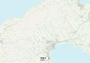


-

Georgia Collection

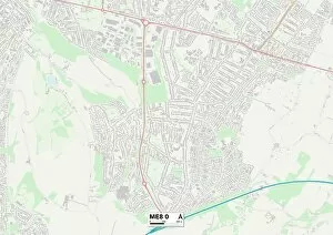
Georgia is a state located in the southeastern region of the United States. It borders Florida to the south, Alabama to the west, Tennessee and North Carolina to the north, and South Carolina to the east. The capital city is Atlanta, which is also its largest city. A diverse geography that includes mountains in the northern part of the state and coastal plains in the southern part. Its economy relies heavily on agriculture, manufacturing, and service industries such as tourism. Georgia's population is over 10 million people with a mix of ethnicities including African American, Hispanic/Latino, Asian American among others.
+

Our beautiful Wall Art and Photo Gifts include Framed Prints, Photo Prints, Poster Prints, Canvas Prints, Jigsaw Puzzles, Metal Prints and so much more

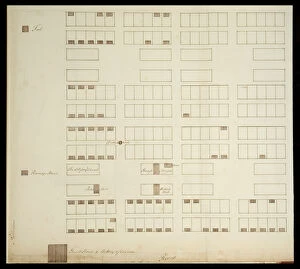
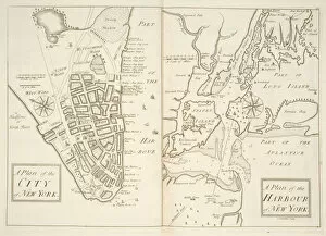
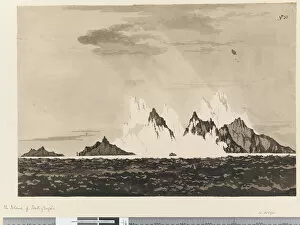
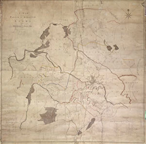
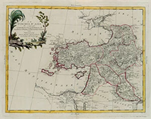
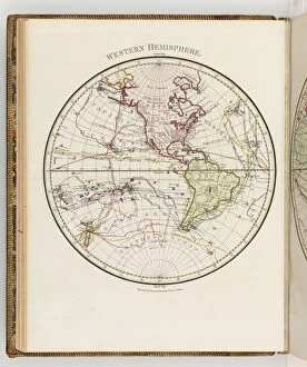
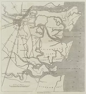
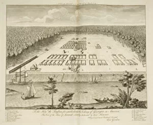
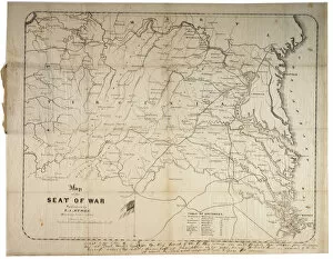
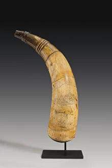
The Georgia collection from Media Storehouse is a stunning compilation of vintage maps and charts that depict the state of Georgia in various eras. Our collection includes detailed topographical maps, antique city plans, historical railroad maps, nautical charts, and more. These beautiful prints are ideal for anyone who loves history or geography or wants to add a touch of elegance to their home decor. Each print in the Georgia collection is carefully reproduced using high-quality materials such as fine art paper or canvas. The prints are available in different sizes to suit any space, from small offices to large living rooms. They can be framed with a variety of frames that complement any interior design style. Whether you're looking for a unique gift idea for someone special or want to decorate your own home with something truly special, the Georgia collection from Media Storehouse is an excellent choice.
+

What are Georgia (Maps and Charts) art prints?

Georgia art prints are high-quality reproductions of vintage maps and charts depicting the state of Georgia. These prints showcase the intricate details of historical cartography, including topographical features, city layouts, and transportation routes. We offer a unique glimpse into the past and provide an excellent way to decorate homes or offices with a touch of nostalgia. These art prints come in various sizes to suit different preferences and spaces. They are printed on premium paper using advanced printing technology that ensures vibrant colors, sharp lines, and long-lasting quality. The Georgia art prints are perfect for history buffs, geography enthusiasts, or anyone who appreciates beautiful artwork. Whether you want to add some character to your living room or create a focal point in your office space, these art prints will make an excellent addition to any wall. With their timeless appeal and classic style, they are sure to impress visitors while also providing a source of inspiration for years to come.
+

What Georgia (Maps and Charts) art prints can I buy from Media Storehouse?

We offer a wide range of Georgia maps and charts art prints that you can purchase. These include antique maps, vintage travel posters, city street maps, topographical maps, and nautical charts. You can choose from various sizes and framing options to suit your preferences. The antique maps showcase the historical evolution of Georgia's geography over time. The vintage travel posters capture the beauty of Georgia's landscapes and attractions in an artistic way. The city street maps provide a detailed view of major cities like Atlanta and Savannah while the topographical maps offer a comprehensive understanding of Georgia's terrain. Moreover, Media Storehouse also has nautical charts that depict the coastal regions around Georgia with intricate details such as water depths, currents, tides, and landmarks. Whether you are looking for decorative pieces or educational resources about Georgia's geography or history, we have something for everyone.
+

How do I buy Georgia (Maps and Charts) art prints?

To purchase Georgia art prints from Media Storehouse, you can browse our extensive collection of artwork online. Once you have found the print that you would like to buy, simply add it to your cart and proceed to checkout. You will be prompted to enter your billing and shipping information before completing the purchase. We offer a variety of payment options including credit card, PayPal, and Apple Pay. We also offer international shipping for customers outside of the United States. Their Georgia art prints are available in a range of sizes and formats including framed prints, canvas prints, metal prints, and more. Whether you're looking for a small print to display on your desk or a large statement piece for your living room wall, we have something for everyone. With high-quality printing technology used in all their products combined with excellent customer service support team makes shopping at Media Storehouse an enjoyable experience.
+

How much do Georgia (Maps and Charts) art prints cost?

We offer a wide range of Georgia art prints that are available for purchase. Our prices vary depending on the size and type of print you choose. We have a selection of high-quality paper prints that are perfect for framing or displaying as is. Alternatively, we also offer canvas prints which provide a more contemporary look and feel to your artwork. Our Georgia art prints come in various sizes ranging from small to large so you can find the perfect fit for your space. Each print is carefully crafted using premium materials to ensure longevity and durability. We take pride in offering affordable pricing without compromising on quality. Whether you're looking for an eye-catching piece to add some personality to your home or office, our Georgia art prints are sure to impress.
+

How will my Georgia (Maps and Charts) art prints be delivered to me?

We take great care in delivering your Georgia art prints to you. We use high-quality packaging materials to ensure that your artwork arrives safely and undamaged. Your print will be carefully rolled and placed inside a sturdy cardboard tube for protection during transit. We work with trusted courier partners who provide reliable delivery services worldwide. Once your order has been dispatched, you will receive a tracking number so that you can keep an eye on its progress. Our standard delivery times vary depending on the destination country, but we aim to deliver within 5-10 working days for UK orders and up to 14 working days for international orders. If you have any questions or concerns about the delivery of your Georgia art prints, please do not hesitate to contact our customer service team who will be happy to assist you.