Home > Europe > United Kingdom > Wales > Powys > Montgomery
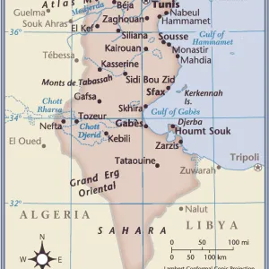
Mareth Line, Tunisia, by G. H. Davis

![]()
Wall Art and Photo Gifts from Mary Evans Picture Library
Mareth Line, Tunisia, by G. H. Davis
A large-scale contour map of the complicated Mareth Line in Tunisia, North Africa, where General Montgomery stated that the enemys fate would be decided. It was the tactical objective of Allied operations at this stage of the Second World War. Date: 1943
Mary Evans Picture Library makes available wonderful images created for people to enjoy over the centuries
Media ID 14125816
© Illustrated London News Ltd/Mary Evans
1943 Allied Allies Contour Davis Decided Djerba Enemy Fate Germans Gulf Maps Montgomery Operations Scale Strategy Tactical Tunisia Tunisian Gabes Objective
FEATURES IN THESE COLLECTIONS
> Europe
> United Kingdom
> Wales
> Powys
> Montgomery
> Maps and Charts
> Early Maps
> Maps and Charts
> World
EDITORS COMMENTS
This large-scale contour map, created by G.H. Davis in 1943, depicts the intricate Mareth Line in Tunisia, North Africa, a strategic position that became the tactical objective of Allied operations during the Second World War. The Mareth Line was a series of fortifications and defensive positions extending from the Gulf of Gabes to the Mediterranean Sea, and was the Germans' final defensive line in Tunisia before their retreat. The line was named after the nearby town of Mareth, and was considered a formidable obstacle due to its natural defenses, including mountains, islands, and the Bou Grara and Grara rivers. At the time this map was made, the outcome of the war in North Africa was uncertain, and the fate of the Axis powers in the region was a topic of intense debate. Allied Commander-in-Chief, General Bernard Montgomery, famously declared that the enemy's fate would be decided at the Mareth Line. The Allied forces launched a series of attacks against the position, culminating in the Battle of Wadi Akarit in March 1943, which ultimately led to the German retreat and the end of the Tunisian campaign. This map provides a detailed view of the complex terrain and strategic features of the Mareth Line, including the Djerba Island, the mountains, and the various fortifications and defensive positions. It is an invaluable historical document, offering insights into the military strategy and tactics employed by both sides during the North African campaign of the Second World War.
MADE IN AUSTRALIA
Safe Shipping with 30 Day Money Back Guarantee
FREE PERSONALISATION*
We are proud to offer a range of customisation features including Personalised Captions, Color Filters and Picture Zoom Tools
SECURE PAYMENTS
We happily accept a wide range of payment options so you can pay for the things you need in the way that is most convenient for you
* Options may vary by product and licensing agreement. Zoomed Pictures can be adjusted in the Cart.