Metal Print > Arts > Artists > G > Giovanni Xenodocus da Corfu
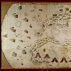
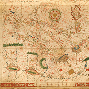
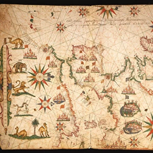
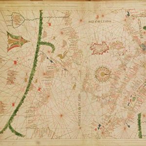
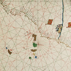
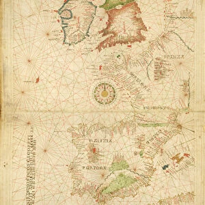
Metal Print : North Africa, from a nautical atlas, 1520 (ink on vellum) (detail from 330916)
 (detail from 330916)")


![]()
Metal Prints from Fine Art Finder
North Africa, from a nautical atlas, 1520 (ink on vellum) (detail from 330916)
XOT330918 North Africa, from a nautical atlas, 1520 (ink on vellum) (detail from 330916) by Giovanni Xenodocus da Corfu (fl. 16th Century); Museo Correr, Venice, Italy; Greek, out of copyright
Media ID 18255147
© Museo Correr, Venice, Italy / Bridgeman Images
Chart Cities Libya Malta Mapping Mediterranean Sea Portolan Tunisia
10"x8" (25x20cm) Table Top Metal Print
Step back in time with our exquisite Media Storehouse Metal Prints, featuring intricate detail from the historic map "North Africa, from a Nautical Atlas, 1520 (ink on vellum)" by Giovanni Xenodocus da Corfu. This stunning vintage map, now out of copyright, offers a glimpse into the past with its intricate lines and captivating cartography. Our high-quality Metal Prints bring the rich history and intricate details of this 16th-century masterpiece to life, making it a beautiful addition to any home or office decor.
Table Top Metal Prints feature rounded corners and an easel back for easy display. Available in two sizes, 18x13cm (7x5) or 25x20cm (10x8). Lightweight and vibrant, they are perfect for displaying artwork and are guaranteed to add style to any desk or table top. The unique material is fade, moisture, chemical and scratch resistant to help ensure this art lasts a lifetime.
Made with durable metal and luxurious printing techniques, metal prints bring images to life and add a modern touch to any space
Estimated Product Size is 25.4cm x 20.3cm (10" x 8")
These are individually made so all sizes are approximate
Artwork printed orientated as per the preview above, with landscape (horizontal) or portrait (vertical) orientation to match the source image.
FEATURES IN THESE COLLECTIONS
> Fine Art Finder
> Artists
> G
> Giovanni Xenodocus da Corfu Giovanni
> Fine Art Finder
> Artists
> Giovanni Xenodocus da Corfu
> Africa
> Libya
> Related Images
> Africa
> Related Images
> Africa
> Tunisia
> Related Images
> Arts
> Artists
> G
> Giovanni Xenodocus da Corfu
> Europe
> Greece
> Related Images
EDITORS COMMENTS
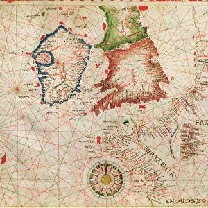
This print showcases a detailed section of North Africa from a nautical atlas created in 1520 by the talented Giovanni Xenodocus da Corfu. The ink on vellum medium adds an exquisite touch to this historical masterpiece, which is currently housed at the Museo Correr in Venice, Italy. The intricate detail and precision of this map highlight the expertise of da Corfu as a cartographer. It offers a fascinating glimpse into the cities and ports that dotted the North African coastline during the 16th century. From Tunisia to Libya, and even Malta, every city is meticulously depicted with accuracy and artistry. As we explore this image further, we are transported back in time to an era when maritime travel played a crucial role in shaping world history. The Mediterranean Sea served as both a gateway for trade routes and a battleground for empires seeking dominance. This particular print allows us to appreciate not only its aesthetic beauty but also its historical significance. It reminds us of how maps were once invaluable tools for sailors navigating treacherous waters and discovering new lands. Whether you are an avid lover of cartography or simply intrigued by ancient civilizations, this stunning piece will undoubtedly captivate your imagination. Its timeless appeal transcends generations, making it a true treasure worth cherishing.
MADE IN AUSTRALIA
Safe Shipping with 30 Day Money Back Guarantee
FREE PERSONALISATION*
We are proud to offer a range of customisation features including Personalised Captions, Color Filters and Picture Zoom Tools
SECURE PAYMENTS
We happily accept a wide range of payment options so you can pay for the things you need in the way that is most convenient for you
* Options may vary by product and licensing agreement. Zoomed Pictures can be adjusted in the Cart.