Metal Print > North America > United States of America > Illinois > Chicago
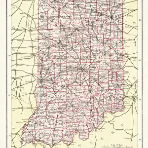
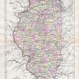
Metal Print : Illinois map 1881


![]()
Metal Prints from Fine Art Storehouse
Illinois map 1881
Encyclopedia Britannica 9th Edition Vol XII Philadelphia j.M. Stoddart & Co 1881
Unleash your creativity and transform your space into a visual masterpiece!
THEPALMER
Media ID 13611523
© This content is subject to copyright
Chicago Illinois Illinois North America Paper World Map
10"x8" (25x20cm) Table Top Metal Print
Step back in time with our exquisite Metal Print of the Illinois Map from the 9th Edition of Encyclopedia Britannica, published in 1881 by J.M. Stoddart & Co in Philadelphia. This vintage map, titled "Illinois" and created by THEPALMER, is now available as a stunning Metal Print from Media Storehouse. The high-quality metal print process brings out the intricate details of the map, making it a unique and eye-catching addition to any room. Relive history with this beautiful piece of art that showcases the geography and borders of Illinois during the late 19th century. Order now and bring a piece of the past into your home or office.
Table Top Metal Prints feature rounded corners and an easel back for easy display. Available in two sizes, 18x13cm (7x5) or 25x20cm (10x8). Lightweight and vibrant, they are perfect for displaying artwork and are guaranteed to add style to any desk or table top. The unique material is fade, moisture, chemical and scratch resistant to help ensure this art lasts a lifetime.
Made with durable metal and luxurious printing techniques, metal prints bring images to life and add a modern touch to any space
Estimated Product Size is 20.3cm x 25.4cm (8" x 10")
These are individually made so all sizes are approximate
Artwork printed orientated as per the preview above, with landscape (horizontal) or portrait (vertical) orientation to match the source image.
FEATURES IN THESE COLLECTIONS
> Fine Art Storehouse
> The Magical World of Illustration
> Palmer Illustrated Collection
> Fine Art Storehouse
> Map
> Historical Maps
> Fine Art Storehouse
> Map
> USA Maps
> Maps and Charts
> Related Images
> Maps and Charts
> World
> North America
> Related Images
> North America
> United States of America
> Illinois
> Chicago
> North America
> United States of America
> Illinois
> Related Images
> North America
> United States of America
> Maps
EDITORS COMMENTS
This print showcases a remarkable piece of history, the "Illinois map 1881" from the Encyclopedia Britannica 9th Edition. Published in Philadelphia by J. M. Stoddart & Co in 1881, this antique illustration takes us back to a time when cartography was meticulously crafted by skilled engravers. The intricate details and precision of this map transport us to the vibrant state of Illinois during that era. The vertical composition allows for an immersive experience as we explore the physical geography of Illinois within its broader context in North America and the United States. From Chicago's bustling urban landscape to the sprawling natural wonders across the state, this map offers a glimpse into Illinois' rich heritage. Printed on high-quality paper, this print captures every fine line and delicate stroke with utmost clarity and authenticity. It serves as a testament to both artistic craftsmanship and historical significance. Whether you are an avid collector or simply fascinated by old-world maps, "Illinois map 1881" is sure to captivate your imagination. Let it transport you back in time as you marvel at its beauty and appreciate the artistry behind early cartography. A true treasure for any admirer of vintage illustrations or those seeking a unique piece of history to adorn their walls.
MADE IN AUSTRALIA
Safe Shipping with 30 Day Money Back Guarantee
FREE PERSONALISATION*
We are proud to offer a range of customisation features including Personalised Captions, Color Filters and Picture Zoom Tools
SECURE PAYMENTS
We happily accept a wide range of payment options so you can pay for the things you need in the way that is most convenient for you
* Options may vary by product and licensing agreement. Zoomed Pictures can be adjusted in the Cart.