Metal Print > North America > United States of America > New York > New York > Maps
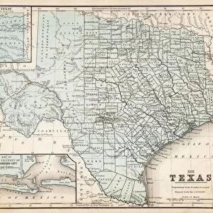
Metal Print : Map of Texas 1855


![]()
Metal Prints from Fine Art Storehouse
Map of Texas 1855
System of Geography for the use of schools by Sidney E. Morse - Published by Harper & Brothers - New York 1855
Unleash your creativity and transform your space into a visual masterpiece!
THEPALMER
Media ID 13668807
© Roberto A Sanchez
Backgrounds Frame Grunge Grunge Image Technique Gulf Coast States Map03 North America Paper Patina Stained Texas Textured Effect West Direction Wild West Obsolete Retro Styled
10"x8" (25x20cm) Table Top Metal Print
Discover the rich history of Texas with our stunning Metal Print of the 1855 Map of Texas by THEPALMER from the Media Storehouse Fine Art Storehouse collection. This intricately detailed map, taken from "A System of Geography for the use of schools" by Sidney E. Morse, published by Harper & Brothers in New York, showcases the early settlements, rivers, and borders of the Lone Star State. The high-quality Metal Print preserves the vintage look and feel of the original map, while the advanced printing technology ensures vibrant colors and sharp details. Bring a piece of historical Texas into your home or office and make it a conversation starter with this unique and captivating decor piece.
Table Top Metal Prints feature rounded corners and an easel back for easy display. Available in two sizes, 18x13cm (7x5) or 25x20cm (10x8). Lightweight and vibrant, they are perfect for displaying artwork and are guaranteed to add style to any desk or table top. The unique material is fade, moisture, chemical and scratch resistant to help ensure this art lasts a lifetime.
Made with durable metal and luxurious printing techniques, metal prints bring images to life and add a modern touch to any space
Estimated Product Size is 20.3cm x 25.4cm (8" x 10")
These are individually made so all sizes are approximate
Artwork printed orientated as per the preview above, with landscape (horizontal) or portrait (vertical) orientation to match the source image.
FEATURES IN THESE COLLECTIONS
> Fine Art Storehouse
> The Magical World of Illustration
> Palmer Illustrated Collection
> Fine Art Storehouse
> Map
> Historical Maps
> Fine Art Storehouse
> Map
> USA Maps
> Maps and Charts
> Related Images
> North America
> Related Images
> North America
> United States of America
> Maps
> North America
> United States of America
> New York
> New York
> Maps
> North America
> United States of America
> New York
> Related Images
> North America
> United States of America
> Texas
> Related Images
EDITORS COMMENTS
This vintage print of the "Map of Texas 1855" takes us back in time to the era of the Wild West. Published by Harper & Brothers in New York, this engraved image showcases a beautifully detailed cartography that was once used for educational purposes in schools. The retro-styled map, with its stained and textured effect, exudes an air of nostalgia and patina. The frame surrounding the map adds to its old-world charm, while the grunge image technique gives it a weathered appearance. As we gaze upon this piece, we are transported to a bygone era when Texas was still developing as part of North America's expanding frontier. The map itself provides insight into the physical geography of Texas during that period. It highlights key landmarks such as the Gulf Coast states and offers a glimpse into how early settlers navigated through this vast territory. Printed on aged paper, this engraving captures not only historical accuracy but also evokes a sense of adventure and exploration. Its vertical orientation allows us to appreciate every intricate detail meticulously etched onto its surface. "The Map of Texas 1855" is more than just an obsolete artifact; it is an artistic representation that tells stories from our past. With its grunge aesthetic and captivating illustration style, it serves as both a decorative piece for any space and a window into history's rich tapestry
MADE IN AUSTRALIA
Safe Shipping with 30 Day Money Back Guarantee
FREE PERSONALISATION*
We are proud to offer a range of customisation features including Personalised Captions, Color Filters and Picture Zoom Tools
SECURE PAYMENTS
We happily accept a wide range of payment options so you can pay for the things you need in the way that is most convenient for you
* Options may vary by product and licensing agreement. Zoomed Pictures can be adjusted in the Cart.