Metal Print > North America > United States of America > New York > New York > Maps
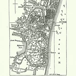
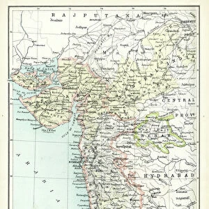
Metal Print : North Dakota and MInnesota map 1881


![]()
Metal Prints from Fine Art Storehouse
North Dakota and MInnesota map 1881
Coltons Common School Geography 1881 New York Sheldon and Co
Unleash your creativity and transform your space into a visual masterpiece!
THEPALMER
Media ID 13669269
© This content is subject to copyright
American Culture Globe Navigational Equipment Minnesota North America North Dakota Paper Planet Earth South Dakota World Map
10"x8" (25x20cm) Table Top Metal Print
Discover the rich history of the American heartland with our stunning Metal Print of the North Dakota and Minnesota map from 1881. This vintage geography map, sourced from Colton's Common School Geography published by Sheldon and Co, New York, showcases intricate detail and accurate cartography of the region during that era. The high-quality Metal Print preserves the authentic look and feel of the original map, while the advanced printing technology ensures vibrant colors and sharp lines. Bring a piece of historical cartography into your home or office and add a unique, educational touch to your decor. Order now and travel back in time with this captivating piece from Media Storehouse's Fine Art collection.
Table Top Metal Prints feature rounded corners and an easel back for easy display. Available in two sizes, 18x13cm (7x5) or 25x20cm (10x8). Lightweight and vibrant, they are perfect for displaying artwork and are guaranteed to add style to any desk or table top. The unique material is fade, moisture, chemical and scratch resistant to help ensure this art lasts a lifetime.
Made with durable metal and luxurious printing techniques, metal prints bring images to life and add a modern touch to any space
Estimated Product Size is 25.4cm x 20.3cm (10" x 8")
These are individually made so all sizes are approximate
Artwork printed orientated as per the preview above, with landscape (horizontal) or portrait (vertical) orientation to match the source image.
FEATURES IN THESE COLLECTIONS
> Fine Art Storehouse
> The Magical World of Illustration
> Palmer Illustrated Collection
> Fine Art Storehouse
> Map
> Historical Maps
> Fine Art Storehouse
> Map
> USA Maps
> Maps and Charts
> Related Images
> Maps and Charts
> World
> North America
> Related Images
> North America
> United States of America
> Maps
> North America
> United States of America
> Minnesota
> Related Images
> North America
> United States of America
> New York
> New York
> Maps
> North America
> United States of America
> New York
> Related Images
> North America
> United States of America
> North Dakota
> Related Images
> North America
> United States of America
> South Dakota
> Related Images
EDITORS COMMENTS
This print takes us back in time to the year 1881, where we find ourselves immersed in the intricate details of a map titled "North Dakota and Minnesota". This vintage piece is extracted from Coltons Common School Geography, a renowned publication that was widely used during that era. The map itself showcases the states of North Dakota and Minnesota, nestled within the vast landscape of North America. Engraved with utmost precision and artistry, this illustration offers a glimpse into an age when cartography was meticulously crafted by hand. The delicate lines etched on paper reveal not only geographical features but also provide insights into American culture at that time. It serves as a testament to the importance placed on understanding physical geography and navigating our planet Earth. The inclusion of globe navigational equipment further enhances its historical significance, reminding us of how explorers once relied upon such tools to traverse uncharted territories. As we gaze upon this antique masterpiece created by THEPALMER for Fine Art Storehouse, we are transported back to an era where maps were cherished possessions offering both knowledge and adventure. Whether you are an enthusiast of history or simply appreciate fine art, this print invites you to immerse yourself in a world long gone by – one filled with curiosity about distant lands and appreciation for the craftsmanship behind these engraved images.
MADE IN AUSTRALIA
Safe Shipping with 30 Day Money Back Guarantee
FREE PERSONALISATION*
We are proud to offer a range of customisation features including Personalised Captions, Color Filters and Picture Zoom Tools
SECURE PAYMENTS
We happily accept a wide range of payment options so you can pay for the things you need in the way that is most convenient for you
* Options may vary by product and licensing agreement. Zoomed Pictures can be adjusted in the Cart.