Metal Print > Europe > United Kingdom > Scotland > Edinburgh > Edinburgh
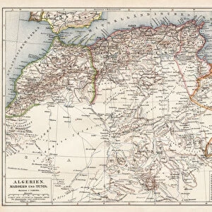
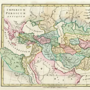
Metal Print : Map of the Barbary States, 1902. Creator: Unknown


![]()
Metal Prints from Heritage Images
Map of the Barbary States, 1902. Creator: Unknown
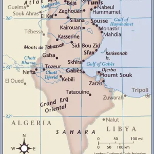
Map of the Barbary States, 1902. Showing Morocco, Algeria, Tunisia, and Libya on the North African coast, with inset of Gibraltar. From The Century Atlas of the World. [John Walker & Co, Ltd. London, 1902]
Heritage Images features heritage image collections
Media ID 15512426
© The Print Collector / Heritage-Images
Algeria Coastline Edinburgh Geographical Institute Libya Mediterranean Sea Morocco North Africa Tunisia Barbary Coast
10"x8" (25x20cm) Table Top Metal Print
Discover the rich history of North Africa with our stunning Metal Print of the Barbary States Map from 1902. This vintage map, sourced from Heritage Images, showcases the intricate detail of the Barbary States, including Morocco, Algeria, Tunisia, and Libya. The inset of Gibraltar adds an extra layer of historical context. Our high-quality Metal Prints are not only beautiful works of art, but also durable and long-lasting, making them a perfect addition to any home or office. Bring history to life with this unique and captivating piece.
Table Top Metal Prints feature rounded corners and an easel back for easy display. Available in two sizes, 18x13cm (7x5) or 25x20cm (10x8). Lightweight and vibrant, they are perfect for displaying artwork and are guaranteed to add style to any desk or table top. The unique material is fade, moisture, chemical and scratch resistant to help ensure this art lasts a lifetime.
Made with durable metal and luxurious printing techniques, metal prints bring images to life and add a modern touch to any space
Estimated Product Size is 25.4cm x 20.3cm (10" x 8")
These are individually made so all sizes are approximate
Artwork printed orientated as per the preview above, with landscape (horizontal) or portrait (vertical) orientation to match the source image.
FEATURES IN THESE COLLECTIONS
> Africa
> Algeria
> Related Images
> Africa
> Libya
> Related Images
> Africa
> Morocco
> Related Images
> Africa
> Tunisia
> Related Images
> Europe
> United Kingdom
> Scotland
> Edinburgh
> Edinburgh
> Europe
> United Kingdom
> Scotland
> Lothian
> Edinburgh
EDITORS COMMENTS
This print showcases a Map of the Barbary States, created in 1902 by an unknown artist. The map provides a detailed representation of Morocco, Algeria, Tunisia, and Libya along the North African coast. It also includes an inset of Gibraltar, adding to its historical significance. The vibrant colors used in this print bring life to the continent and highlight the diverse landscapes found within these regions. Created during the early 20th century, this map offers valuable insights into Africa's geographical features and political boundaries at that time. The Edinburgh Geographical Institute is credited for producing this remarkable piece which was featured in The Century Atlas of the World published by John Walker & Co. , Ltd. , London in 1902. Its inclusion in such a prestigious publication further emphasizes its importance as a reliable source for geographic information. Preserved by The Print Collector, this image captures not only the beauty but also serves as a testament to our ever-evolving understanding of global geography. As we explore this map today, it allows us to appreciate how much has changed over time while providing context for historical events that shaped these nations.
MADE IN AUSTRALIA
Safe Shipping with 30 Day Money Back Guarantee
FREE PERSONALISATION*
We are proud to offer a range of customisation features including Personalised Captions, Color Filters and Picture Zoom Tools
SECURE PAYMENTS
We happily accept a wide range of payment options so you can pay for the things you need in the way that is most convenient for you
* Options may vary by product and licensing agreement. Zoomed Pictures can be adjusted in the Cart.