Metal Print > Europe > France > Canton > Allier
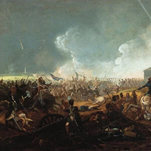
Metal Print : Plan of Sevastopol with its roadstead & fortifications, c


![]()
Metal Prints from Heritage Images
Plan of Sevastopol with its roadstead & fortifications, c
Plan of Sevastopol with its roadstead & fortifications, c. 1858. From a private collection
Heritage Images features heritage image collections
Media ID 19048491
© Fine Art Images/Heritage Images
Allied Troops Allies Anonymous Master Artillery Batteries Battle Of Sevastopol Black Sea Cartography Crimea Crimean War Defence Defence Of Sevastopol Great Britain Malakoff Redoubt Ottoman Empire Russian Forces Sebastopol Sevastopol Siege Siege Of Sevastopol War Atrocities
10"x8" (25x20cm) Table Top Metal Print
Bring history to life with our exquisite Media Storehouse Metal Prints. This captivating image showcases a detailed Plan of Sevastopol with its roadstead and fortifications, dating back to 1858. Meticulously sourced from a private collection, this vintage map transports you back in time, offering a glimpse into the rich history of the Black Sea. Our premium metal prints are not just beautiful decorative pieces, but also a testament to the intriguing stories of the past. Order yours today and let the legacy of Sevastopol unfold in your home or office.
Table Top Metal Prints feature rounded corners and an easel back for easy display. Available in two sizes, 18x13cm (7x5) or 25x20cm (10x8). Lightweight and vibrant, they are perfect for displaying artwork and are guaranteed to add style to any desk or table top. The unique material is fade, moisture, chemical and scratch resistant to help ensure this art lasts a lifetime.
Made with durable metal and luxurious printing techniques, metal prints bring images to life and add a modern touch to any space
Estimated Product Size is 25.4cm x 20.3cm (10" x 8")
These are individually made so all sizes are approximate
Artwork printed orientated as per the preview above, with landscape (horizontal) or portrait (vertical) orientation to match the source image.
FEATURES IN THESE COLLECTIONS
> Europe
> France
> Canton
> Allier
> Europe
> Russia
> Related Images
> Historic
> Battles
> Related Images
> Maps and Charts
> British Empire Maps
EDITORS COMMENTS
This print showcases the intricate "Plan of Sevastopol with its roadstead & fortifications" dating back to approximately 1858. Hailing from a private collection, this anonymous masterpiece offers a glimpse into the historic Battle of Sevastopol during the Crimean War. The detailed etching provides an invaluable cartographic representation of the city's defences, including artillery, batteries, and the renowned Malakoff Redoubt. As one explores this fine art image, it becomes evident that this plan played a crucial role in strategizing for both allied troops and Russian forces involved in the siege of Sevastopol. With Great Britain and France as key players alongside their Ottoman Empire allies, this map symbolizes unity amidst war atrocities. The significance of Sevastopol's location on the Black Sea is highlighted by its well-fortified roadstead and defensive structures depicted within this watercolour-like print. It serves as a testament to history while shedding light on how nations fought fiercely for control over Crimea. Admiring such graphic arts allows us to delve into past conflicts while appreciating the dedication put forth by those who meticulously documented these events. This particular piece not only preserves historical knowledge but also evokes curiosity about an era marked by bravery and resilience.
MADE IN AUSTRALIA
Safe Shipping with 30 Day Money Back Guarantee
FREE PERSONALISATION*
We are proud to offer a range of customisation features including Personalised Captions, Color Filters and Picture Zoom Tools
SECURE PAYMENTS
We happily accept a wide range of payment options so you can pay for the things you need in the way that is most convenient for you
* Options may vary by product and licensing agreement. Zoomed Pictures can be adjusted in the Cart.