Metal Print > Maps and Charts > World
Metal Print : World map 1784 showing the Cook Voyages


![]()
Metal Prints from Mary Evans Picture Library
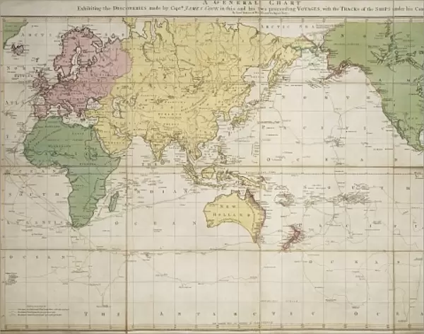
World map 1784 showing the Cook Voyages
A general chart exhibiting the discoveries made by Captain James Cook in this and his preceeding voyages with tracks of the ships under his command
Mary Evans Picture Library makes available wonderful images created for people to enjoy over the centuries
Media ID 8580777
© Mary Evans Picture Library 2015 - https://copyrighthub.org/s0/hub1/creation/maryevans/MaryEvansPictureID/10707966
1784 18th Century Captain Cook Captain James Cook Chart Continent Cook Discovery Track Voyage
14"x11" (28x35cm) Metal Print
Discover the world through history with our stunning Metal Prints from Media Storehouse, featuring the captivating World Map of 1784 from Rights Managed at Mary Evans Prints Online. This intricately detailed map showcases the groundbreaking discoveries made by Captain James Cook and his ships during his voyages. Bring this piece of historical cartography into your home or office and let it tell the story of exploration and adventure. Our high-quality Metal Prints are not only visually appealing but also durable and long-lasting, making them a great investment for any space. Order yours today and embark on a journey through time.
Our Metal Prints feature rounded corners and rear fixings for easy wall mounting. Images are directly printed onto a lightweight, high quality 5mm thick, durable metallic surface for a vivid and vibrant finish. Available in 2 sizes, 28x35cm (14x11) and 50x40cm (20x16). The unique material is fade, moisture, chemical and scratch resistant to help ensure this art lasts a lifetime.
Made with durable metal and luxurious printing techniques, metal prints bring images to life and add a modern touch to any space
Estimated Product Size is 35.5cm x 27.9cm (14" x 11")
These are individually made so all sizes are approximate
Artwork printed orientated as per the preview above, with landscape (horizontal) or portrait (vertical) orientation to match the source image.
FEATURES IN THESE COLLECTIONS
> Maps and Charts
> Related Images
> Maps and Charts
> World
EDITORS COMMENTS
This stunning print of the World map from 1784 showcases the incredible discoveries made by Captain James Cook during his voyages in the 18th century. The detailed chart not only highlights the tracks of the ships under his command but also provides a fascinating glimpse into the vast continents and territories explored during this era of exploration.
Captain Cook's expeditions were instrumental in expanding our understanding of the world, as he ventured into uncharted waters and mapped out new lands with precision and accuracy. His legacy is immortalized in this historic map, which serves as a testament to his pioneering spirit and determination to push boundaries.
As you gaze upon this image, you can almost envision yourself sailing alongside Captain Cook on his daring adventures across the globe. The intricate details and vibrant colors bring to life a time when discovery was at its peak, and every voyage held the promise of new horizons waiting to be uncovered.
Whether you're a history buff or simply appreciate fine art, this print is sure to spark your curiosity and ignite your sense of wanderlust. It's a reminder that there are still countless mysteries waiting to be unraveled, just like those that captivated Captain James Cook all those years ago.
MADE IN AUSTRALIA
Safe Shipping with 30 Day Money Back Guarantee
FREE PERSONALISATION*
We are proud to offer a range of customisation features including Personalised Captions, Color Filters and Picture Zoom Tools
SECURE PAYMENTS
We happily accept a wide range of payment options so you can pay for the things you need in the way that is most convenient for you
* Options may vary by product and licensing agreement. Zoomed Pictures can be adjusted in the Cart.