Metal Print > Europe > United Kingdom > England > Maps
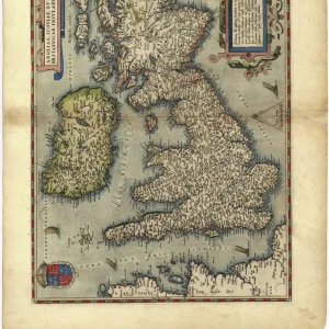
Metal Print : Relief map of the United Kingdom and Eire


![]()
Metal Prints from Science Photo Library
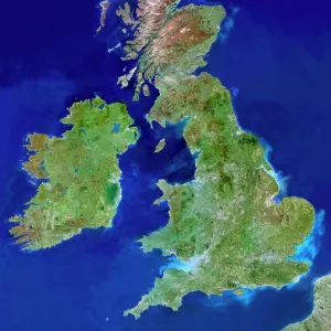
Relief map of the United Kingdom and Eire
Relief map of the United Kingdom and Eire, lit from the east
Science Photo Library features Science and Medical images including photos and illustrations
Media ID 6349171
© JULIAN BAUM/SCIENCE PHOTO LIBRARY
British Isles Earth Science From Space Great Ireland Relief Relief Map Sciences
10"x8" (25x20cm) Table Top Metal Print
Discover the breathtaking beauty of the United Kingdom and Ireland with our Media Storehouse Metal Prints. Featuring an intricately detailed relief map of the region, this stunning piece is brought to life with our high-quality metal printing process. The vibrant colors and impressive textures pop against the sleek, durable metal surface, making it a captivating addition to any room. Illuminated from the east, this Relief map of the United Kingdom and Eire by Science Photo Library transports you to the heart of Europe's rich history and culture. Order now and bring a piece of this magnificent land to your home or office.
Table Top Metal Prints feature rounded corners and an easel back for easy display. Available in two sizes, 18x13cm (7x5) or 25x20cm (10x8). Lightweight and vibrant, they are perfect for displaying artwork and are guaranteed to add style to any desk or table top. The unique material is fade, moisture, chemical and scratch resistant to help ensure this art lasts a lifetime.
Made with durable metal and luxurious printing techniques, metal prints bring images to life and add a modern touch to any space
Estimated Product Size is 20.3cm x 25.4cm (8" x 10")
These are individually made so all sizes are approximate
Artwork printed orientated as per the preview above, with landscape (horizontal) or portrait (vertical) orientation to match the source image.
FEATURES IN THESE COLLECTIONS
> Europe
> Republic of Ireland
> Maps
> Europe
> United Kingdom
> England
> Maps
> Europe
> United Kingdom
> Maps
> Europe
> United Kingdom
> Related Images
> Maps and Charts
> Related Images
EDITORS COMMENTS
This print showcases a stunning relief map of the United Kingdom and Eire, beautifully illuminated from the east. The intricate details and textures of this topographic representation are brought to life, allowing viewers to immerse themselves in the diverse landscapes that make up these British Isles. From the rugged mountains of Scotland to the rolling hills of England and Wales, every contour is meticulously depicted on this map. It provides a unique perspective on the geographical features that shape this region, offering an opportunity to appreciate its natural beauty from a different vantage point. The lighting choice for this photograph adds depth and dimension to the relief map, casting shadows that emphasize elevations and depressions across the landmasses. This technique enhances our understanding of how geography influences climate patterns, river systems, and even human settlements within these territories. As we gaze upon this image captured by Science Photo Library's talented photographers, we are reminded of Earth's incredible diversity and complexity. This visual representation serves as a valuable educational tool for students studying earth sciences or anyone with an interest in geography or cartography. Whether displayed in classrooms or homes alike, this mesmerizing relief map invites us to explore Britain and Ireland through a new lens – one that encourages appreciation for both their physical characteristics and cultural heritage.
MADE IN AUSTRALIA
Safe Shipping with 30 Day Money Back Guarantee
FREE PERSONALISATION*
We are proud to offer a range of customisation features including Personalised Captions, Color Filters and Picture Zoom Tools
SECURE PAYMENTS
We happily accept a wide range of payment options so you can pay for the things you need in the way that is most convenient for you
* Options may vary by product and licensing agreement. Zoomed Pictures can be adjusted in the Cart.