Metal Print > Europe > Portugal > Maps
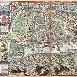
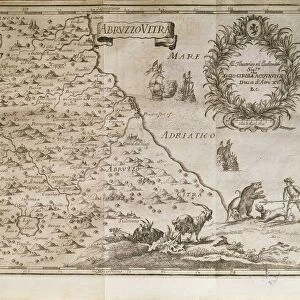
Metal Print : Map of Goa, flourishing Portuguese colony in the Indian peninsula, 1635


![]()
Metal Prints from Universal Images Group (UIG)
Map of Goa, flourishing Portuguese colony in the Indian peninsula, 1635
Cartography, 17th century. Map of Goa, flourishing Portuguese colony in the Indian peninsula, 1635
Universal Images Group (UIG) manages distribution for many leading specialist agencies worldwide
Media ID 9571943
© BRITISH LIBRARY
17th Century Coastline Colonialism Colony India Peninsula World Map
14"x11" (28x35cm) Metal Print
Discover the rich history of the Indian peninsula with our stunning Metal Print of the Map of Goa from Universal Images Group. Dating back to 1635, this exquisite 17th-century map showcases the flourishing Portuguese colony in Goa during its peak. The intricate cartography detailing the coastline, rivers, and territories of the region is brought to life through our high-quality Metal Print process. Add a touch of history and sophistication to your home or office decor with this unique and captivating piece.
Our Metal Prints feature rounded corners and rear fixings for easy wall mounting. Images are directly printed onto a lightweight, high quality 5mm thick, durable metallic surface for a vivid and vibrant finish. Available in 2 sizes, 28x35cm (14x11) and 50x40cm (20x16). The unique material is fade, moisture, chemical and scratch resistant to help ensure this art lasts a lifetime.
Made with durable metal and luxurious printing techniques, metal prints bring images to life and add a modern touch to any space
Estimated Product Size is 35.5cm x 27.9cm (14" x 11")
These are individually made so all sizes are approximate
Artwork printed orientated as per the preview above, with landscape (horizontal) or portrait (vertical) orientation to match the source image.
FEATURES IN THESE COLLECTIONS
> Asia
> India
> Related Images
> Europe
> Portugal
> Paintings
> Europe
> Portugal
> Related Images
> Maps and Charts
> India
> Maps and Charts
> Related Images
> Maps and Charts
> World
> Universal Images Group (UIG)
> Art
> Painting, Sculpture & Prints
> Cartography
EDITORS COMMENTS
This print showcases a remarkable piece of history - the Map of Goa, a flourishing Portuguese colony in the Indian peninsula during the 17th century. Crafted with intricate detail and precision, this cartographic masterpiece offers a glimpse into an era defined by colonialism and exploration. The map's horizontal layout beautifully captures the topography of Goa, situated on a scenic peninsula along India's coastline. Every stroke and contour meticulously depicts the geographical features that made this Portuguese colony so strategically significant. As we delve into its rich details, we are transported back to 1635 when European powers were vying for dominance in far-flung lands. The illustration and painting techniques employed here bring life to this historical artifact, allowing us to marvel at how early cartographers skillfully captured their world. What makes this image truly fascinating is its absence of people; it invites us to ponder upon the impact of colonialism on indigenous populations while appreciating the artistry behind these maps. It serves as both a reminder of our complex past and an opportunity for reflection on how geography has shaped our present-day world. This extraordinary photograph from Universal Images Group (UIG) encapsulates not only an important chapter in human history but also celebrates the artistry and craftsmanship involved in creating such invaluable pieces of cartography
MADE IN AUSTRALIA
Safe Shipping with 30 Day Money Back Guarantee
FREE PERSONALISATION*
We are proud to offer a range of customisation features including Personalised Captions, Color Filters and Picture Zoom Tools
SECURE PAYMENTS
We happily accept a wide range of payment options so you can pay for the things you need in the way that is most convenient for you
* Options may vary by product and licensing agreement. Zoomed Pictures can be adjusted in the Cart.