Metal Print > Asia > South Korea > Maps
Metal Print : South Korea, Relief Map with Border and Mask


![]()
Metal Prints from Universal Images Group (UIG)
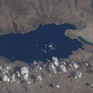
South Korea, Relief Map with Border and Mask
Relief map of South Korea (with border and mask). This image was compiled from data acquired by landsat 5 & 7 satellites combined with elevation data
Universal Images Group (UIG) manages distribution for many leading specialist agencies worldwide
Media ID 9619241
© Planet Observer/UIG
Coastline Korean Peninsula Relief Map Seoul Shore South Korea Satellite View
10"x8" (25x20cm) Table Top Metal Print
Discover the captivating beauty of South Korea with our Media Storehouse Metal Prints featuring a stunning relief map from Universal Images Group (UIG). Meticulously compiled from data acquired by Landsat 5 & 7 satellites and enhanced with elevation data, this unique representation showcases the intricate topography and borders of the vibrant nation. Bring a piece of Asia's technological powerhouse into your home or office with this eye-catching and conversation-starting metal print. Order yours today and elevate your decor with a touch of geographic artistry.
Table Top Metal Prints feature rounded corners and an easel back for easy display. Available in two sizes, 18x13cm (7x5) or 25x20cm (10x8). Lightweight and vibrant, they are perfect for displaying artwork and are guaranteed to add style to any desk or table top. The unique material is fade, moisture, chemical and scratch resistant to help ensure this art lasts a lifetime.
Made with durable metal and luxurious printing techniques, metal prints bring images to life and add a modern touch to any space
Estimated Product Size is 20.3cm x 25.4cm (8" x 10")
These are individually made so all sizes are approximate
Artwork printed orientated as per the preview above, with landscape (horizontal) or portrait (vertical) orientation to match the source image.
FEATURES IN THESE COLLECTIONS
> Asia
> South Korea
> Maps
> Asia
> South Korea
> Related Images
> Asia
> South Korea
> Seoul
> Maps and Charts
> Related Images
> Universal Images Group (UIG)
> Universal Images Group
> Satellite and Aerial
> Planet Observer 4
EDITORS COMMENTS
This print showcases the stunning relief map of South Korea, adorned with a distinct border and mask. Created using data acquired by landsat 5 & 7 satellites, combined with elevation data, this image offers a unique perspective on the physical geography of South Korea. The intricate details captured in this photograph highlight the diverse topography of the region. From its picturesque coastline to its majestic mountain ranges, every element is beautifully depicted in vibrant colors. Seoul, the bustling capital city, stands out as a prominent feature on this map. The vertical composition adds depth and dimension to the image, allowing viewers to immerse themselves in South Korea's natural beauty. This satellite view provides an invaluable tool for cartographers and geographers studying the Korean Peninsula. It offers valuable insights into landforms and geographical features that shape South Korea's landscape. With no people present in this photograph, it allows us to focus solely on appreciating nature's artistry. Universal Images Group (UIG) has once again captured a remarkable moment through their lens. This print not only serves as an aesthetic masterpiece but also as an educational resource for those interested in exploring South Korea's physical terrain
MADE IN AUSTRALIA
Safe Shipping with 30 Day Money Back Guarantee
FREE PERSONALISATION*
We are proud to offer a range of customisation features including Personalised Captions, Color Filters and Picture Zoom Tools
SECURE PAYMENTS
We happily accept a wide range of payment options so you can pay for the things you need in the way that is most convenient for you
* Options may vary by product and licensing agreement. Zoomed Pictures can be adjusted in the Cart.