Metal Print > Europe > France > Canton > Ille
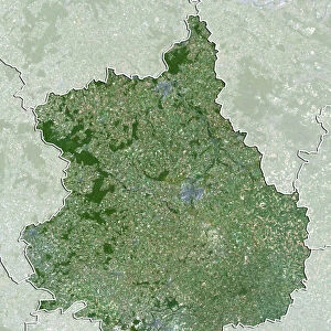
Metal Print : Departement of Ille-et-Vilaine, France, Relief Map


![]()
Metal Prints from Universal Images Group (UIG)
Departement of Ille-et-Vilaine, France, Relief Map
Relief map of the departement of Ille-et-Vilaine, France. It is bordered by the English Channel to the north. This image was compiled from data acquired by LANDSAT 5 & 7 satellites combined with elevation data
Universal Images Group (UIG) manages distribution for many leading specialist agencies worldwide
Media ID 9611987
© Planet Observer
Brittany Coastline Geographical Border Relief Map Shore Ille Et Vilaine Satellite View
10"x8" (25x20cm) Table Top Metal Print
Bring the beauty of the world into your home with our Media Storehouse Metal Prints. This particular piece features a captivating relief map of the Ille-et-Vilaine department in France, sourced from Universal Images Group (UIG). Meticulously compiled from data acquired by LANDSAT 5 & 7 satellites, this detailed map showcases the intricacies of the region's topography. Our high-quality metal prints are not just a decorative addition to your space, but a conversation starter that tells a story. Experience the vibrant colors and stunning details as if you were there. Order now and let your walls come alive!
Table Top Metal Prints feature rounded corners and an easel back for easy display. Available in two sizes, 18x13cm (7x5) or 25x20cm (10x8). Lightweight and vibrant, they are perfect for displaying artwork and are guaranteed to add style to any desk or table top. The unique material is fade, moisture, chemical and scratch resistant to help ensure this art lasts a lifetime.
Made with durable metal and luxurious printing techniques, metal prints bring images to life and add a modern touch to any space
Estimated Product Size is 20.3cm x 25.4cm (8" x 10")
These are individually made so all sizes are approximate
Artwork printed orientated as per the preview above, with landscape (horizontal) or portrait (vertical) orientation to match the source image.
FEATURES IN THESE COLLECTIONS
> Europe
> France
> Canton
> Ille
> Maps and Charts
> Related Images
> Universal Images Group (UIG)
> Universal Images Group
> Satellite and Aerial
> Planet Observer 5
EDITORS COMMENTS
This print showcases the stunning relief map of the Departement of Ille-et-Vilaine in France. Located in the beautiful region of Brittany, this departement is bordered by the majestic English Channel to its north. The intricate details and vibrant colors of this image were meticulously compiled from data acquired by LANDSAT 5 & 7 satellites, combined with elevation data. The photograph provides a bird's-eye view of the physical geography and topography of Ille-et-Vilaine. From its picturesque coastline to its undulating landscapes, every contour is clearly visible, making it an invaluable tool for cartographers and geographers alike. The absence of people in this image allows us to fully appreciate nature's artistry at play. As we gaze upon this vertical composition, we are transported into a world where geographical borders dissolve, leaving only awe-inspiring beauty behind. Whether you're an avid photographer or simply fascinated by maps and satellite views, this print offers a unique perspective on one of France's most enchanting regions. Its color palette evokes a sense of tranquility while simultaneously igniting our curiosity about the secrets hidden within Ille-et-Vilaine's diverse terrain
MADE IN AUSTRALIA
Safe Shipping with 30 Day Money Back Guarantee
FREE PERSONALISATION*
We are proud to offer a range of customisation features including Personalised Captions, Color Filters and Picture Zoom Tools
SECURE PAYMENTS
We happily accept a wide range of payment options so you can pay for the things you need in the way that is most convenient for you
* Options may vary by product and licensing agreement. Zoomed Pictures can be adjusted in the Cart.