Mouse Mat > Arts > Artists > M > Robert Mitchell
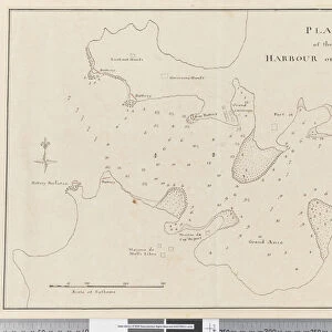
Mouse Mat : Page 37c Plan of the harbour of St. Lucia


![]()
Home Decor from Fine Art Finder
Page 37c Plan of the harbour of St. Lucia
5670304 Page 37c Plan of the harbour of St. Lucia by Unknown artist, (18th century); Mitchell Library, State Library of New South Wales; (add.info.: Original Sketches, Drawings, Maps etc Collected by Admiral Isaac Smith / drawings and watercolours, mainly of Captain Cooks Second Voyage (1772-1775) by William Hodges, Henry Roberts etc
Dimensions: Album measures 49 x 70 cm); Mitchell Library, State Library of New South Wales; out of copyright
Media ID 23584930
© Mitchell Library, State Library of New South Wales / Bridgeman Images
Caribbean Cartographic Compass Geographical Label Labelled Lesser Antilles Mapping Numbers Scale Survey Surveying
Mouse Pad
Bring some life into your office, or create a heartfelt gift, with a personalised deluxe Mouse Mat. Made of high-density black foam with a tough, stain-resistant inter-woven cloth cover they will brighten up any home or corporate office.
Archive quality photographic print in a durable wipe clean mouse mat with non slip backing. Works with all computer mice
Estimated Product Size is 24.2cm x 19.7cm (9.5" x 7.8")
These are individually made so all sizes are approximate
Artwork printed orientated as per the preview above, with landscape (horizontal) or portrait (vertical) orientation to match the source image.
FEATURES IN THESE COLLECTIONS
> Fine Art Finder
> Artists
> Unknown Artist
> Fine Art Finder
> Artists
> William Hodges
> Arts
> Artists
> H
> William Hodges
> Arts
> Artists
> K
> Henry Key
> Arts
> Artists
> M
> Robert Mitchell
> Arts
> Artists
> P
> William Page
> Arts
> Artists
> S
> Robert Smith
> Europe
> United Kingdom
> Wales
> Maps
> Europe
> United Kingdom
> Wales
> Posters
> Europe
> United Kingdom
> Wales
> Related Images
> Maps and Charts
> Related Images
EDITORS COMMENTS
This print showcases "Page 37c Plan of the harbour of St. Lucia" a remarkable piece of cartography from the 18th century. Created by an unknown artist, this map is part of the collection held at Mitchell Library, State Library of New South Wales. The album measures an impressive 49 x 70 cm and features original sketches, drawings, maps, and more collected by Admiral Isaac Smith. The intricately detailed drawing depicts the coastline and shoreline of St. Lucia's harbor with precision and accuracy. Labeled with numbers and accompanied by a key, compass, and scale, this map offers valuable insights into the geography and topography of the Caribbean region during that time. As we delve into its rich history, we are transported back to Captain Cook's Second Voyage (1772-1775), as it includes drawings and watercolors by renowned artists such as William Hodges and Henry Roberts. This fascinating artifact not only serves as a testament to the artistry involved in cartographic surveying but also provides invaluable information about maritime exploration in the XVIIIth century Lesser Antilles region. With its coastal charm and nautical allure, this print captures our imagination while reminding us of centuries past when brave explorers set sail on daring expeditions to uncover new lands.
MADE IN AUSTRALIA
Safe Shipping with 30 Day Money Back Guarantee
FREE PERSONALISATION*
We are proud to offer a range of customisation features including Personalised Captions, Color Filters and Picture Zoom Tools
SECURE PAYMENTS
We happily accept a wide range of payment options so you can pay for the things you need in the way that is most convenient for you
* Options may vary by product and licensing agreement. Zoomed Pictures can be adjusted in the Cart.