Mouse Mat > Animals > Mammals > Cricetidae > Golden Mouse
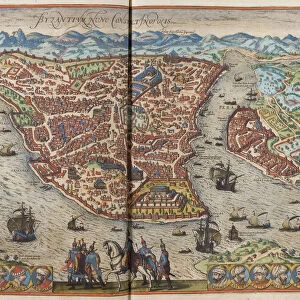
Mouse Mat : Antique map of Constantinople, present day Istanbul


![]()
Home Decor from Fine Art Storehouse
Antique map of Constantinople, present day Istanbul
Unleash your creativity and transform your space into a visual masterpiece!
Hemera Technologies
Media ID 13609419
© Getty Images
Bosphorus Byzantine Constantinople Direction Geography Golden Horn Istanbul Istanbul Legend Location Middle East Place Positioning Turkey Turkey Middle East Bosphorus Strait Byzantium Golden Horn Sea Of Marmara
Mouse Pad
Bring some life into your office, or create a heartfelt gift, with a personalised deluxe Mouse Mat. Made of high-density black foam with a tough, stain-resistant inter-woven cloth cover they will brighten up any home or corporate office.
Archive quality photographic print in a durable wipe clean mouse mat with non slip backing. Works with all computer mice
Estimated Product Size is 24.2cm x 19.7cm (9.5" x 7.8")
These are individually made so all sizes are approximate
Artwork printed orientated as per the preview above, with landscape (horizontal) or portrait (vertical) orientation to match the source image.
FEATURES IN THESE COLLECTIONS
> Fine Art Storehouse
> Map
> Historical Maps
> Animals
> Mammals
> Cricetidae
> Golden Mouse
> Asia
> Related Images
> Asia
> Turkey
> Related Images
> Europe
> Related Images
> Maps and Charts
> Early Maps
> Maps and Charts
> Related Images
EDITORS COMMENTS
This print showcases an antique map of Constantinople, the enchanting city that is now known as Istanbul. With its rich history and cultural significance, this archival piece takes us back in time to explore the ancient wonders of Byzantium. The intricate engravings on this vintage map beautifully depict the geography and positioning of this iconic city, nestled between the Bosphorus Strait and the Sea of Marmara. As we delve into this historical artifact, our eyes are drawn to key landmarks such as the Golden Horn, a natural harbor that has witnessed countless maritime adventures throughout centuries. The detailed legend provides insight into various elements represented on the map, allowing us to navigate through Constantinople's streets and neighborhoods with ease. Transported by Hemera Technologies' skillful photography, we find ourselves immersed in a world where East meets West. This horizontal composition captures every detail in vibrant color, bringing life to each street corner and architectural marvels that have stood tall for generations. With no people present within its frame, this image invites us to reflect upon Constantinople's past glory while contemplating its enduring legacy today. It serves as a reminder of how history shapes our present reality and inspires curiosity about what lies beyond these ancient walls. Whether you're an avid cartography enthusiast or simply captivated by Istanbul's allure, this antique print offers a window into a bygone era - an exquisite addition to any art collection or space longing for timeless beauty.
MADE IN AUSTRALIA
Safe Shipping with 30 Day Money Back Guarantee
FREE PERSONALISATION*
We are proud to offer a range of customisation features including Personalised Captions, Color Filters and Picture Zoom Tools
SECURE PAYMENTS
We happily accept a wide range of payment options so you can pay for the things you need in the way that is most convenient for you
* Options may vary by product and licensing agreement. Zoomed Pictures can be adjusted in the Cart.