Mouse Mat > Europe > France > Canton > Landes
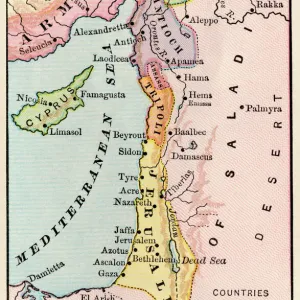
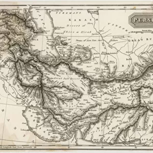
Mouse Mat : Antique map of the Middle East


![]()
Home Decor from Fine Art Storehouse
Antique map of the Middle East
Unleash your creativity and transform your space into a visual masterpiece!
Hemera Technologies
Media ID 13609517
© Getty Images
Arabia Armenia Border Compass Cyprus Direction Document Garden Of Eden Geography Holy Land Iran Legend Location Mediterranean Mediterranean Culture Middle East Navigational Compass Persia Persian Gulf Place Positioning Red Sea Scale
Mouse Pad
Bring some life into your office, or create a heartfelt gift, with a personalised deluxe Mouse Mat. Made of high-density black foam with a tough, stain-resistant inter-woven cloth cover they will brighten up any home or corporate office.
Archive quality photographic print in a durable wipe clean mouse mat with non slip backing. Works with all computer mice
Estimated Product Size is 19.7cm x 24.2cm (7.8" x 9.5")
These are individually made so all sizes are approximate
Artwork printed orientated as per the preview above, with landscape (horizontal) or portrait (vertical) orientation to match the source image.
FEATURES IN THESE COLLECTIONS
> Fine Art Storehouse
> Map
> Historical Maps
> Asia
> Armenia
> Related Images
> Asia
> Cyprus
> Related Images
> Asia
> Iran
> Related Images
> Europe
> Armenia
> Related Images
> Europe
> France
> Canton
> Landes
EDITORS COMMENTS
This print showcases an exquisite antique map of the Middle East, taking us on a journey through time and space. With its intricate details and rich historical significance, this archival piece offers a glimpse into the region's past. The map encompasses various elements that transport us back to ancient times. From the legendary Garden of Eden to the borders of Arabia and Armenia, every feature has been meticulously engraved with precision. The inclusion of navigational compasses emphasizes the importance of exploration during those eras. As we explore further, we encounter key locations such as Persia, Cyprus, and the Red Sea. These markings provide insights into trade routes and cultural exchanges that shaped Mediterranean culture throughout history. The Persian Gulf stands out prominently, reminding us of its strategic position in connecting different civilizations. Accompanied by a detailed legend and scale for reference, this vintage gem serves not only as a geographical tool but also as a testament to human curiosity about our world's physical geography. Hemera Technologies' photography captures this antique map in all its glory - vertical in orientation with vibrant colors that bring life to each contour line and symbol. The absence of people allows us to focus solely on appreciating the artistry behind this historical document. Whether you are an avid collector or simply fascinated by history, this remarkable print is sure to ignite your imagination while adding an air of sophistication to any space it graces
MADE IN AUSTRALIA
Safe Shipping with 30 Day Money Back Guarantee
FREE PERSONALISATION*
We are proud to offer a range of customisation features including Personalised Captions, Color Filters and Picture Zoom Tools
SECURE PAYMENTS
We happily accept a wide range of payment options so you can pay for the things you need in the way that is most convenient for you
* Options may vary by product and licensing agreement. Zoomed Pictures can be adjusted in the Cart.