Mouse Mat > Europe > United Kingdom > England > Maps
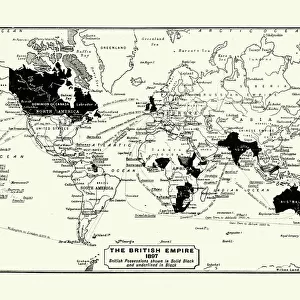
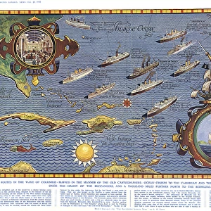
Mouse Mat : Development of the British Empire, lithograph, published 1897


![]()
Home Decor from Fine Art Storehouse
Development of the British Empire, lithograph, published 1897
Map of the territorial development of the British Empire from the 17th century to the end of the 19th century. Lithograph, published in 1897
Unleash your creativity and transform your space into a visual masterpiece!
Media ID 15387303
© This content is subject to copyright
17th Century 18th Century America Australia British Culture British Empire Brown Central America Colonial Colonization Colony Empire English Culture India Latin America North America South Africa South America Topographic Map World Map Multi Colored Victorian Era White Color
Mouse Pad
Bring some life into your office, or create a heartfelt gift, with a personalised deluxe Mouse Mat. Made of high-density black foam with a tough, stain-resistant inter-woven cloth cover they will brighten up any home or corporate office.
Archive quality photographic print in a durable wipe clean mouse mat with non slip backing. Works with all computer mice
Estimated Product Size is 24.2cm x 19.7cm (9.5" x 7.8")
These are individually made so all sizes are approximate
Artwork printed orientated as per the preview above, with landscape (horizontal) or portrait (vertical) orientation to match the source image.
FEATURES IN THESE COLLECTIONS
> Fine Art Storehouse
> Map
> Historical Maps
> Africa
> Related Images
> Africa
> South Africa
> Maps
> Africa
> South Africa
> Related Images
> Arts
> Landscape paintings
> Landscape art
> Landscape paintings
> Asia
> India
> Related Images
> Asia
> Related Images
> Europe
> Related Images
> Europe
> United Kingdom
> England
> Maps
> Europe
> United Kingdom
> England
> Posters
EDITORS COMMENTS
This lithograph, published in 1897, offers a visual journey through the remarkable territorial expansion of the British Empire. Spanning from the 17th century to the end of the 19th century, this topographic map showcases the vast extent of British colonization across continents and oceans. The intricate details and vibrant colors bring to life an era defined by exploration and conquest. From Europe to America, North and South America to Latin America, Central Africa to South Africa, India to Asia, and even Australia - this map encapsulates centuries of history within its horizontal landscape. As we gaze upon this print, we are transported back in time - witnessing how England's influence shaped cultures around the world. The brown hues symbolize land conquered while blue signifies territories claimed by sea power. It is a testament not only to Britain's military might but also their enduring cultural impact. This lithograph serves as a reminder of both triumphs and controversies associated with colonialism during that period. It invites us to reflect on historical events that have shaped our present-day global landscape. A true treasure for history enthusiasts or anyone seeking insight into British culture and its imperial legacy; it stands as a testament to human ambition and exploration amidst an ever-changing world.
MADE IN AUSTRALIA
Safe Shipping with 30 Day Money Back Guarantee
FREE PERSONALISATION*
We are proud to offer a range of customisation features including Personalised Captions, Color Filters and Picture Zoom Tools
SECURE PAYMENTS
We happily accept a wide range of payment options so you can pay for the things you need in the way that is most convenient for you
* Options may vary by product and licensing agreement. Zoomed Pictures can be adjusted in the Cart.