Mouse Mat > Europe > France > Maps
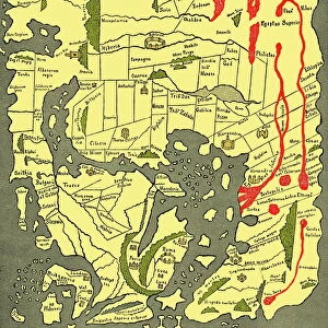
Mouse Mat : Map of Ancient Gaul (France)
")

![]()
Home Decor from Fine Art Storehouse
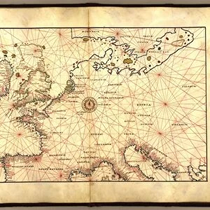
Map of Ancient Gaul (France)
Vintage engraving of a Map of Ancient Gaul (France)
Unleash your creativity and transform your space into a visual masterpiece!
duncan1890
Media ID 13609279
© This content is subject to copyright
Ancient History Celtic Style Central Europe Equipment European Culture Navigational Equipment Styles Classical Style Gaul Gauls
Mouse Pad
Bring some life into your office, or create a heartfelt gift, with a personalised deluxe Mouse Mat. Made of high-density black foam with a tough, stain-resistant inter-woven cloth cover they will brighten up any home or corporate office.
Archive quality photographic print in a durable wipe clean mouse mat with non slip backing. Works with all computer mice
Estimated Product Size is 19.7cm x 24.2cm (7.8" x 9.5")
These are individually made so all sizes are approximate
Artwork printed orientated as per the preview above, with landscape (horizontal) or portrait (vertical) orientation to match the source image.
FEATURES IN THESE COLLECTIONS
> Fine Art Storehouse
> Map
> Historical Maps
> Europe
> Related Images
> Historic
> Ancient civilizations
> Historic
> Cultural festivals and traditions
> Maps and Charts
> Early Maps
> Maps and Charts
> Related Images
EDITORS COMMENTS
This print takes us on a journey back in time to ancient Gaul, now known as France. The vintage engraving beautifully depicts the intricate details of this historical map, showcasing the rich heritage and cultural significance of this region. The Map of Ancient Gaul transports us to a bygone era, where tradition and classical style prevailed. With its Celtic influences evident in the artistic rendering, we are reminded of the ancient civilization that once thrived here. As we explore this archival piece, our eyes are drawn to the navigational equipment depicted within the illustration. It serves as a reminder of how far we have come in terms of technological advancements since then. Central Europe comes alive through this woodcut print, allowing us to appreciate European culture from centuries ago. The meticulous craftsmanship showcased in every line and curve speaks volumes about the dedication put into creating such an exquisite work of art. With its roots dating back before Christ (BC), this antique map offers a glimpse into ancient history that continues to fascinate scholars and enthusiasts alike. Duncan1890's attention to detail brings forth an appreciation for both geography and history. Whether displayed in a home or office setting, this vertical print is sure to spark conversations about Gauls, their legacy, and their impact on European history.
MADE IN AUSTRALIA
Safe Shipping with 30 Day Money Back Guarantee
FREE PERSONALISATION*
We are proud to offer a range of customisation features including Personalised Captions, Color Filters and Picture Zoom Tools
SECURE PAYMENTS
We happily accept a wide range of payment options so you can pay for the things you need in the way that is most convenient for you
* Options may vary by product and licensing agreement. Zoomed Pictures can be adjusted in the Cart.