Mouse Mat > Europe > United Kingdom > England > London > Art > Theatre
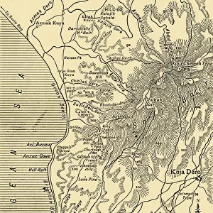
Mouse Mat : ANZAC advance, Gallipoli peninsula, First World War, 1915, (c1920). Creator: Unknown
. Creator: Unknown")

![]()
Home Decor from Heritage Images
ANZAC advance, Gallipoli peninsula, First World War, 1915, (c1920). Creator: Unknown
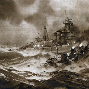
ANZAC advance, Gallipoli peninsula, First World War, 1915, (c1920). Map illustrating the Plan of Attack in the Main Anzac Advance of August 6-7, 1915. The Gallipoli peninsula in Turkey was the scene of heavy fighting between the allied forces of the British Empire including Australia, and New Zealand, and the Turkish Ottoman Empire. A and B represent the right and left covering columns; C and D the right and left assaulting columns. From " The Great World War - A History" Volume IV, edited by Frank A Mumby. [The Gresham Publishing Company Ltd, London, c1920]
Heritage Images features heritage image collections
Media ID 19174477
© The Print Collector/Heritage Images
Advance Advancing Aegean Aegean Sea Anzac Cove Cove Frank Arthur Frank Arthur Mumby Gallipoli Campaign Gallipoli Peninsula Gallipoli Peninsula Turkey Gresham Publishing Co Ltd Gresham Publishing Company Keystone Archives Mumby Mumby Frank Arthur The Great World War A History Theatre Of War Turkey
Mouse Pad
Bring some life into your office, or create a heartfelt gift, with a personalised deluxe Mouse Mat. Made of high-density black foam with a tough, stain-resistant inter-woven cloth cover they will brighten up any home or corporate office.
Archive quality photographic print in a durable wipe clean mouse mat with non slip backing. Works with all computer mice
Estimated Product Size is 24.2cm x 19.7cm (9.5" x 7.8")
These are individually made so all sizes are approximate
Artwork printed orientated as per the preview above, with landscape (horizontal) or portrait (vertical) orientation to match the source image.
FEATURES IN THESE COLLECTIONS
> Asia
> Turkey
> Related Images
> Europe
> United Kingdom
> England
> London
> Art
> Theatre
> Historic
> Battles
> Related Images
> Historic
> World War I and II
> World War I
> Historic
> World War I and II
> Maps and Charts
> British Empire Maps
> Maps and Charts
> Related Images
> Maps and Charts
> World
EDITORS COMMENTS
This print captures the ANZAC advance on the Gallipoli peninsula during the First World War in 1915. The image, taken around 1920 by an unknown creator, showcases a map illustrating the Plan of Attack in the Main Anzac Advance that took place on August 6-7,1915. The Gallipoli peninsula in Turkey witnessed intense fighting between allied forces from the British Empire, including Australia and New Zealand, and the Turkish Ottoman Empire. This historic battle is depicted through A and B representing right and left covering columns, while C and D symbolize right and left assaulting columns. Published in "The Great World War - A History". Volume IV edited by Frank A Mumby (c1920), this print offers a glimpse into one of the most significant campaigns of World War I. It highlights not only geographical features like Aegean Sea but also emphasizes key locations such as Anzac Cove, Sari Bair Heights, and Sari Bair Ridge. As we reflect upon this image today, it serves as a reminder of the sacrifices made by soldiers from different nations who fought bravely amidst challenging circumstances. Their determination to secure victory echoes through time as we honor their legacy. This photograph stands as a testament to their courage on that fateful battlefield over a century ago.
MADE IN AUSTRALIA
Safe Shipping with 30 Day Money Back Guarantee
FREE PERSONALISATION*
We are proud to offer a range of customisation features including Personalised Captions, Color Filters and Picture Zoom Tools
SECURE PAYMENTS
We happily accept a wide range of payment options so you can pay for the things you need in the way that is most convenient for you
* Options may vary by product and licensing agreement. Zoomed Pictures can be adjusted in the Cart.