Mouse Mat > Asia > China > Maps
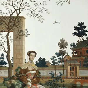
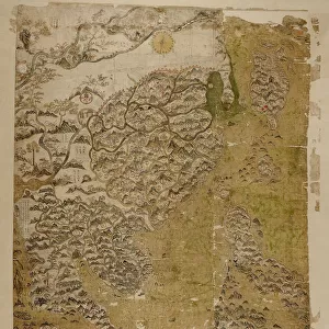
Mouse Mat : Kunyu Wanguo Quantu (A Map of the Myriad Countries of the World), 1602. Artist: Zhong Wentao (17th century)
, 1602. Artist: Zhong Wentao (17th century)")

![]()
Home Decor from Heritage Images
Kunyu Wanguo Quantu (A Map of the Myriad Countries of the World), 1602. Artist: Zhong Wentao (17th century)
Kunyu Wanguo Quantu (A Map of the Myriad Countries of the World), 1602. Found in the collection of the Biblioteca Apostolica Vaticana
Heritage Images features heritage image collections
Media ID 15015630
© Fine Art Images
Biblioteca Apostolica Vaticana Cartography Ink On Parchment Ming Dynasty World Map
Mouse Pad
Bring some life into your office, or create a heartfelt gift, with a personalised deluxe Mouse Mat. Made of high-density black foam with a tough, stain-resistant inter-woven cloth cover they will brighten up any home or corporate office.
Archive quality photographic print in a durable wipe clean mouse mat with non slip backing. Works with all computer mice
Estimated Product Size is 24.2cm x 19.7cm (9.5" x 7.8")
These are individually made so all sizes are approximate
Artwork printed orientated as per the preview above, with landscape (horizontal) or portrait (vertical) orientation to match the source image.
FEATURES IN THESE COLLECTIONS
> Historic
> Ancient civilizations
> Chinese Dynasties
> Historic
> Chinese dynasties paintings
> Maps and Charts
> Related Images
> Maps and Charts
> World
EDITORS COMMENTS
This print showcases the remarkable "Kunyu Wanguo Quantu (A Map of the Myriad Countries of the World)" created in 1602 by Zhong Wentao, an artist from the 17th century Ming Dynasty. Housed within the prestigious collection of Biblioteca Apostolica Vaticana, this map is a testament to both its historical significance and artistic brilliance. Rendered with intricate detail and precision, this world map offers a unique perspective on cartography during that era. Created using ink on parchment, it presents an array of countries and territories known at that time. The careful placement of cities, rivers, mountains, and coastlines highlights not only geographical accuracy but also provides insight into cultural exchanges between nations. As one delves deeper into this masterpiece's graphic arts, it becomes evident that every stroke carries immense meaning. The use of vibrant colors adds depth to each region while simultaneously emphasizing their individuality. This visual representation serves as a valuable resource for historians studying global interactions during the Ming Dynasty. Preserved through centuries in Biblioteca Apostolica Vaticana's archives, this artwork stands as a testament to human curiosity about our world's vastness. Its presence reminds us of how far we have come in understanding our planet while acknowledging the enduring beauty found within ancient maps like these.
MADE IN AUSTRALIA
Safe Shipping with 30 Day Money Back Guarantee
FREE PERSONALISATION*
We are proud to offer a range of customisation features including Personalised Captions, Color Filters and Picture Zoom Tools
SECURE PAYMENTS
We happily accept a wide range of payment options so you can pay for the things you need in the way that is most convenient for you
* Options may vary by product and licensing agreement. Zoomed Pictures can be adjusted in the Cart.