Mouse Mat > Europe > United Kingdom > Scotland > Edinburgh > Edinburgh
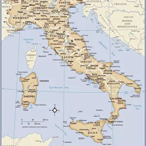
Mouse Mat : Map of Italy, 1902. Creator: Unknown


![]()
Home Decor from Heritage Images
Map of Italy, 1902. Creator: Unknown
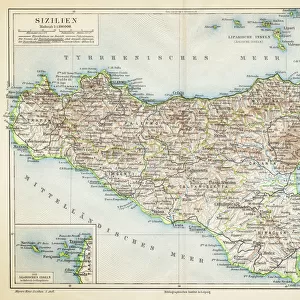
Map of Italy, 1902. Showing the various administrative regions, the islands of Sardinia and Sicily, with inset of Rome. From The Century Atlas of the World. [John Walker & Co, Ltd. London, 1902]
Heritage Images features heritage image collections
Media ID 15512382
© The Print Collector / Heritage-Images
Coastline Edinburgh Geographical Institute Province Provinces Region Regions
Mouse Pad
Bring some life into your office, or create a heartfelt gift, with a personalised deluxe Mouse Mat. Made of high-density black foam with a tough, stain-resistant inter-woven cloth cover they will brighten up any home or corporate office.
Archive quality photographic print in a durable wipe clean mouse mat with non slip backing. Works with all computer mice
Estimated Product Size is 19.7cm x 24.2cm (7.8" x 9.5")
These are individually made so all sizes are approximate
Artwork printed orientated as per the preview above, with landscape (horizontal) or portrait (vertical) orientation to match the source image.
FEATURES IN THESE COLLECTIONS
> Europe
> Italy
> Lazio
> Rome
> Europe
> Italy
> Sardinia
> Related Images
> Europe
> Italy
> Sicily
> Related Images
> Europe
> United Kingdom
> Scotland
> Edinburgh
> Edinburgh
> Europe
> United Kingdom
> Scotland
> Lothian
> Edinburgh
> Maps and Charts
> Italy
> Maps and Charts
> Related Images
> Maps and Charts
> World
EDITORS COMMENTS
This print showcases a Map of Italy from the year 1902, created by an unknown artist. The intricate details and vibrant colors bring to life the various administrative regions of Italy, including the enchanting islands of Sardinia and Sicily. A fascinating inset of Rome adds further depth to this historical piece. The Century Atlas of the World, published by John Walker & Co in London, is responsible for preserving this remarkable snapshot in time. The map not only serves as a geographical guide but also provides insight into Italy's rich history and cultural diversity during the early 20th century. The coastline stretches along the stunning Italian coastlines, capturing both mainland and island territories with precision. Each province is meticulously outlined, allowing viewers to explore different regions at a glance. Although we may never know who precisely crafted this masterpiece, its significance lies in its ability to transport us back in time. This print offers a glimpse into an era when cartography was both an art form and a means of discovery. Preserved by The Print Collector and now available through Heritage Images, this extraordinary map invites us to delve into Italy's past while appreciating its enduring beauty.
MADE IN AUSTRALIA
Safe Shipping with 30 Day Money Back Guarantee
FREE PERSONALISATION*
We are proud to offer a range of customisation features including Personalised Captions, Color Filters and Picture Zoom Tools
SECURE PAYMENTS
We happily accept a wide range of payment options so you can pay for the things you need in the way that is most convenient for you
* Options may vary by product and licensing agreement. Zoomed Pictures can be adjusted in the Cart.