Photo Mug > Fine Art Finder > Artists > Abraham (after) Cresques
Photo Mug : Detail of Copy of a Catalan Map of Europe and North Africa, presented to Charles


Resolution may be poor at this size (79 DPI)
![]()
Home Decor from Fine Art Finder
Detail of Copy of a Catalan Map of Europe and North Africa, presented to Charles
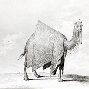
XCF291064 Detail of Copy of a Catalan Map of Europe and North Africa, presented to Charles V of France in 1381 (vellum) by Cresques, Abraham (1325-87) (after); British Museum, London, UK; (add.info.: see also 75614 for entire; ); French, out of copyright
Media ID 12814145
© www.bridgemanart.com
Arabs Atlantic Ocean Camel Chart Cities Compass Gibraltar Mediterranean Moors Moroccan Morocco Navigation Navigational Portolan Rhumb Lines Mallorcan
Photo Mug
Bring your favorite historical maps to life with our Media Storehouse Photo Mugs. This exquisite design features a detailed copy of a Catalan Map of Europe and North Africa, presented to Charles V of France in 1381. The map, created by the renowned cartographer Abraham Cresques, showcases intricate detail and vibrant colors. Each mug holds your favorite beverage while transporting you back in time. Perfect for history enthusiasts or as a unique gift. Image courtesy of Bridgeman Art Library from Fine Art Finder (XCF291064).
A personalised photo mug blends sentimentality with functionality, making an ideal gift for cherished loved ones, close friends, or valued colleagues. Preview may show both sides of the same mug.
Elevate your coffee or tea experience with our premium white ceramic mug. Its wide, comfortable handle makes drinking easy, and you can rely on it to be both microwave and dishwasher safe. Sold in single units, preview may show both sides of the same mug so you can see how the picture wraps around.
Mug Size is 8.1cm high x 9.6cm diameter (3.2" x 3.8")
These are individually made so all sizes are approximate
EDITORS COMMENTS
This print showcases a mesmerizing "Detail of Copy of a Catalan Map of Europe and North Africa". Created by the talented Abraham Cresques in 1381, this exquisite piece was presented to Charles V of France. The map, rendered on vellum, is housed in the prestigious British Museum in London. The intricate details depicted in this artwork transport us back to an era when navigation and exploration were at their peak. The portolan chart highlights various cities and towns across Europe and North Africa, providing invaluable information for sailors embarking on daring voyages. Rhumb lines crisscross the map, serving as navigational aids during maritime journeys. One cannot help but be drawn to the majestic ships sailing through the Atlantic Ocean towards Gibraltar and into the Mediterranean Sea. These vessels symbolize both trade routes and expeditions that shaped history. Alongside them are camels representing African culture while also signifying Morocco's influence on Spain during that time. Amidst all these elements lies King Charles V himself, adorned with his regal crown. This detail emphasizes his authority over vast territories encompassing both European and African lands. As we delve deeper into this image, we encounter male and female figures representing Moors or Arabs—a testament to cultural diversity within medieval society. Their presence speaks volumes about historical connections between different civilizations. Intriguingly crafted with precision and artistry, this photograph allows us to appreciate not only its aesthetic beauty but also its historical significance as a valuable artifact from centuries past.
MADE IN AUSTRALIA
Safe Shipping with 30 Day Money Back Guarantee
FREE PERSONALISATION*
We are proud to offer a range of customisation features including Personalised Captions, Color Filters and Picture Zoom Tools
SECURE PAYMENTS
We happily accept a wide range of payment options so you can pay for the things you need in the way that is most convenient for you
* Options may vary by product and licensing agreement. Zoomed Pictures can be adjusted in the Cart.