Photo Mug > Europe > United Kingdom > Wales > Maps
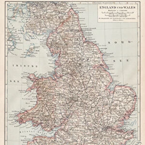
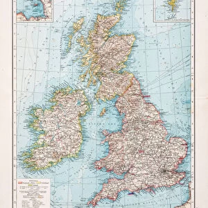
Photo Mug : Map of England and Wales 1889


![]()
Home Decor from Fine Art Storehouse
Map of England and Wales 1889
Comprehensive Geography by James Monteith - American Book Company 1882, 1889
Unleash your creativity and transform your space into a visual masterpiece!
THEPALMER
Media ID 18357301
Photo Mug
Bring a piece of historical cartography to your daily routine with our Media Storehouse Photo Mug featuring the intricately detailed Map of England and Wales from 1889 by THEPALMER, originally published in Comprehensive Geography by James Monteith from the American Book Company. This high-quality mug showcases the vintage map design on both sides, making it a unique and thoughtful gift for history buffs, geography enthusiasts, or anyone who appreciates the beauty of old maps. Each mug is dishwasher and microwave safe, ensuring durability and convenience. Enjoy your favorite beverage while exploring the rich history of England and Wales with every sip.
A personalised photo mug blends sentimentality with functionality, making an ideal gift for cherished loved ones, close friends, or valued colleagues. Preview may show both sides of the same mug.
Elevate your coffee or tea experience with our premium white ceramic mug. Its wide, comfortable handle makes drinking easy, and you can rely on it to be both microwave and dishwasher safe. Sold in single units, preview may show both sides of the same mug so you can see how the picture wraps around.
Mug Size is 9.6cm high x 8.1cm diameter (3.8" x 3.2")
These are individually made so all sizes are approximate
FEATURES IN THESE COLLECTIONS
> Fine Art Storehouse
> Map
> Historical Maps
> Europe
> United Kingdom
> England
> Maps
> Europe
> United Kingdom
> England
> Posters
> Europe
> United Kingdom
> England
> Related Images
> Europe
> United Kingdom
> Wales
> Maps
> Europe
> United Kingdom
> Wales
> Posters
> Europe
> United Kingdom
> Wales
> Related Images
> Maps and Charts
> Related Images
> Maps and Charts
> Wales
EDITORS COMMENTS
In this print titled "Map of England and Wales 1889" we are transported back in time to an era when cartography was both a science and an art form. The map, originally featured in James Monteith's renowned Comprehensive Geography book published by the American Book Company in 1882 and updated in 1889, is a testament to the meticulous craftsmanship of its creator. As we gaze upon this vintage masterpiece skillfully captured by THEPALMER for Fine Art Storehouse, every intricate detail comes alive. From the delicate lines outlining each county to the carefully chosen colors representing different regions, it is evident that this map was not only meant to inform but also inspire wonder. The historical significance of this particular edition cannot be understated. It serves as a window into late Victorian England and Wales, offering glimpses into their rich cultural heritage, bustling cities, quaint towns, and picturesque landscapes. Whether used as an educational tool or admired purely for its aesthetic appeal, this map transports us on a journey through time while simultaneously reminding us of our interconnectedness with past generations. THEPALMER's expert photography captures the essence of this antique treasure flawlessly. With impeccable lighting and composition choices, they have transformed a two-dimensional object into a work of art that invites viewers to explore history from an entirely new perspective. This print undoubtedly deserves its place among fine art collections worldwide.
MADE IN AUSTRALIA
Safe Shipping with 30 Day Money Back Guarantee
FREE PERSONALISATION*
We are proud to offer a range of customisation features including Personalised Captions, Color Filters and Picture Zoom Tools
SECURE PAYMENTS
We happily accept a wide range of payment options so you can pay for the things you need in the way that is most convenient for you
* Options may vary by product and licensing agreement. Zoomed Pictures can be adjusted in the Cart.