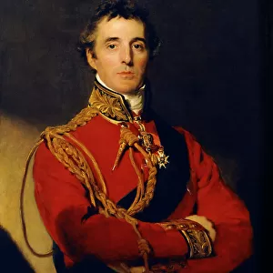
Photo Mug > Europe > United Kingdom > England > London > Politics > William Lamb
Photo Mug : Map of Essex, 1678. Artists: John Ogilby, William Morgan


![]()
Home Decor from Heritage Images
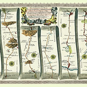
Map of Essex, 1678. Artists: John Ogilby, William Morgan
Map of Essex, 1678. From Essex, actually surveyed, with the several Roads from London &c. by Francis Lamb. [Philip Lea, Essex, 1678]
Heritage Images features heritage image collections
Media ID 14978299
© The Print Collector
Cartography Coat Of Arms County Essex Francis Heraldry Lamb Map Making Morgan Ogilby John Ogilby William Morgan
Photo Mug
Introducing the Media Storehouse Photo Mug, a unique and thoughtful gift that lets you take your favorite historical images with you wherever you go. This exquisite mug showcases a captivating map of Essex from 1678, meticulously created by John Ogilby and William Morgan. This antique map, originally published by Francis Lamb in Essex, offers a fascinating glimpse into the past with its intricate details of roads from London and beyond. Bring history to life with each sip from this beautifully designed mug, making it an essential addition to any tea or coffee break.
A personalised photo mug blends sentimentality with functionality, making an ideal gift for cherished loved ones, close friends, or valued colleagues. Preview may show both sides of the same mug.
Elevate your coffee or tea experience with our premium white ceramic mug. Its wide, comfortable handle makes drinking easy, and you can rely on it to be both microwave and dishwasher safe. Sold in single units, preview may show both sides of the same mug so you can see how the picture wraps around.
Mug Size is 8.1cm high x 9.6cm diameter (3.2" x 3.8")
These are individually made so all sizes are approximate
FEATURES IN THESE COLLECTIONS
> Heritage Images
> Maps Charts & Plans
> Arts
> Artists
> L
> Philip Lea
> Arts
> Artists
> M
> John Morgan
> Arts
> Artists
> O
> John Ogilby
> Europe
> United Kingdom
> England
> Essex
> Related Images
> Europe
> United Kingdom
> England
> London
> Politics
> William Lamb
> Europe
> United Kingdom
> England
> Maps
> Maps and Charts
> Related Images
EDITORS COMMENTS
This print showcases the intricate and historically significant "Map of Essex, 1678". Crafted by esteemed artists John Ogilby and William Morgan, this map offers a fascinating glimpse into the geography and cartography of 17th century England. The vibrant colors bring to life the various counties and locations within Essex, while also highlighting its rich heritage. The attention to detail is remarkable as every road leading from London is meticulously depicted. This map serves as an invaluable resource for understanding the transportation routes during that era. Additionally, it features exquisite coat of arms symbols representing different regions, adding a touch of heraldry to this masterpiece. Originally surveyed by Francis Lamb, this particular print was published in 1678 by Philip Lea - a testament to its enduring popularity even centuries later. Its inclusion in The Print Collector collection further solidifies its significance in preserving historical artifacts. As we delve into this visual treasure trove, we are transported back in time to witness how British cartography evolved over the years. It reminds us of the immense effort put forth by these talented individuals who dedicated their lives to accurately mapping out our world.
MADE IN AUSTRALIA
Safe Shipping with 30 Day Money Back Guarantee
FREE PERSONALISATION*
We are proud to offer a range of customisation features including Personalised Captions, Color Filters and Picture Zoom Tools
SECURE PAYMENTS
We happily accept a wide range of payment options so you can pay for the things you need in the way that is most convenient for you
* Options may vary by product and licensing agreement. Zoomed Pictures can be adjusted in the Cart.