Photo Mug > Maps and Charts > Related Images
Photo Mug : Old Map of The Manor of Erdington in Warwickshire 1760


![]()
Home Decor from MapSeeker
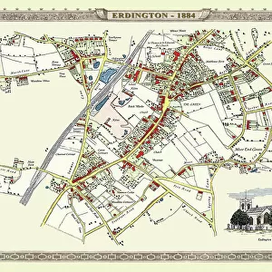
Old Map of The Manor of Erdington in Warwickshire 1760
PL064
Welcome to the Mapseeker Image library and enter an historic gateway to one of the largest on-line collections of Historic Maps, Nostalgic Views, Vista's and Panorama's from a World gone by.
Media ID 20347333
Historic Map Old Town Plan Town Plan Erdington
Photo Mug
"Bring a piece of history to your daily routine with our Media Storehouse Photo Mug featuring an old map of The Manor of Erdington in Warwickshire from MapSeeker (PL064). This high-quality mug showcases intricate details of the 1760 map, making it a unique and thoughtful gift for history enthusiasts or anyone who appreciates the beauty of vintage maps. Each mug is printed with UV-resistant ink to ensure the image remains vibrant and clear, and is dishwasher safe for easy cleaning. Enjoy your favorite beverage while reliving the past with this captivating and functional home decor item."
A personalised photo mug blends sentimentality with functionality, making an ideal gift for cherished loved ones, close friends, or valued colleagues. Preview may show both sides of the same mug.
Elevate your coffee or tea experience with our premium white ceramic mug. Its wide, comfortable handle makes drinking easy, and you can rely on it to be both microwave and dishwasher safe. Sold in single units, preview may show both sides of the same mug so you can see how the picture wraps around.
Mug Size is 9.6cm high x 8.1cm diameter (3.8" x 3.2")
These are individually made so all sizes are approximate
FEATURES IN THESE COLLECTIONS
> MapSeeker
> British Town And City Plans
> English & Welsh PORTFOLIO
> Europe
> United Kingdom
> England
> Warwickshire
> Related Images
> Maps and Charts
> Related Images
EDITORS COMMENTS
This print showcases the "Old Map of The Manor of Erdington in Warwickshire 1760 (PL064)". With its intricate details and historical significance, this map offers a fascinating glimpse into the past. The image transports us back to the year 1760, where we can explore the charming village of Erdington as it once was. This meticulously crafted town plan provides a comprehensive overview of the area, capturing every street, building, and landmark with remarkable precision. As we examine this historic map, we are reminded of Erdington's rich heritage and its importance within Warwickshire. The village itself exudes an old-world charm that is beautifully depicted through this vintage cartographic gem. Every line on this map tells a story - from the winding roads that connect different parts of Erdington to the clusters of houses nestled amidst lush greenery. It allows us to imagine what life was like for residents during that era; their daily routines and interactions within this tight-knit community. Whether you have personal ties to Erdington or simply appreciate historical maps, this print serves as a window into another time. Its aesthetic appeal combined with its educational value makes it an ideal addition to any history enthusiast's collection
MADE IN AUSTRALIA
Safe Shipping with 30 Day Money Back Guarantee
FREE PERSONALISATION*
We are proud to offer a range of customisation features including Personalised Captions, Color Filters and Picture Zoom Tools
SECURE PAYMENTS
We happily accept a wide range of payment options so you can pay for the things you need in the way that is most convenient for you
* Options may vary by product and licensing agreement. Zoomed Pictures can be adjusted in the Cart.