Photo Mug > Maps and Charts > Early Maps
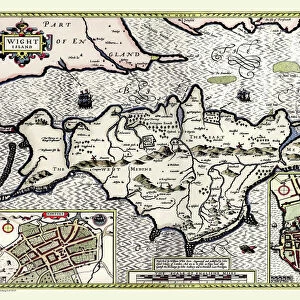
Photo Mug : Early Coastal Survey Map of the Isle of Wight, Spithead and Portsmouth Harbour 1794


![]()
Home Decor from MapSeeker
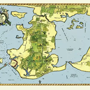
Early Coastal Survey Map of the Isle of Wight, Spithead and Portsmouth Harbour 1794
This is a colour reproduction of the attractive coastal chart of the Isle of Wight, Spithead and Portsmouth Harbour originally published in 1794 by Jos Avery
Welcome to the Mapseeker Image library and enter an historic gateway to one of the largest on-line collections of Historic Maps, Nostalgic Views, Vista's and Panorama's from a World gone by.
Media ID 20347509
Isle Of Wight Portsmouth Harbour Spithead
Photo Mug
Add a touch of maritime history to your daily routine with our Media Storehouse Photo Mug featuring an Early Coastal Survey Map of the Isle of Wight, Spithead, and Portsmouth Harbour from MapSeeker. This beautiful mug showcases a colorful reproduction of the 1794 chart originally published by Jos Avery. Perfect for tea or coffee, this sturdy mug is a great conversation starter and a unique gift for history enthusiasts, sailors, or anyone who appreciates the beauty of vintage maps. Embrace the rich maritime heritage of the Isle of Wight and Portsmouth Harbour with every sip.
A personalised photo mug blends sentimentality with functionality, making an ideal gift for cherished loved ones, close friends, or valued colleagues. Preview may show both sides of the same mug.
Elevate your coffee or tea experience with our premium white ceramic mug. Its wide, comfortable handle makes drinking easy, and you can rely on it to be both microwave and dishwasher safe. Sold in single units, preview may show both sides of the same mug so you can see how the picture wraps around.
Mug Size is 8.1cm high x 9.6cm diameter (3.2" x 3.8")
These are individually made so all sizes are approximate
FEATURES IN THESE COLLECTIONS
> MapSeeker
> Maps from the British Isles
> British Coastal Surveys PORTFOLIO
> MapSeeker
> Maps from the British Isles
> Islands around Britain PORTFOLIO
> Maps and Charts
> Early Maps
> Maps and Charts
> Related Images
EDITORS COMMENTS
This print showcases an exquisite colour reproduction of the Early Coastal Survey Map of the Isle of Wight, Spithead, and Portsmouth Harbour. Originally published in 1794 by the talented cartographer Jos Avery, this map offers a fascinating glimpse into the coastal landscape of that era. The intricate details depicted on this chart provide a valuable historical record of these renowned British locations. The Isle of Wight, with its stunning coastline and diverse topography, is beautifully illustrated with precision and artistry. From sandy beaches to rocky cliffs, every contour is meticulously captured. Spithead, known for its strategic importance as a natural anchorage for naval vessels during that time period, is also prominently featured on this map. Its deep waters and sheltered bay are clearly marked, serving as a reminder of Britain's maritime heritage. Portsmouth Harbour takes center stage in this visual masterpiece. As one of England's most significant naval bases throughout history, it played a crucial role in protecting the nation's shores. This survey map provides invaluable insights into its layout during the late 18th century. Whether you're an avid historian or simply appreciate fine craftsmanship, this print will undoubtedly captivate your imagination. It serves as both an educational tool and a beautiful piece of art that transports you back to an era when coastal surveys were essential for navigation and defense purposes.
MADE IN AUSTRALIA
Safe Shipping with 30 Day Money Back Guarantee
FREE PERSONALISATION*
We are proud to offer a range of customisation features including Personalised Captions, Color Filters and Picture Zoom Tools
SECURE PAYMENTS
We happily accept a wide range of payment options so you can pay for the things you need in the way that is most convenient for you
* Options may vary by product and licensing agreement. Zoomed Pictures can be adjusted in the Cart.