Poster Print > Maps and Charts > Early Maps
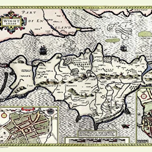
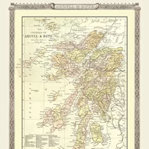
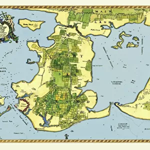
Poster Print : Early Coastal Survey Map of the Isle of Wight, Spithead and Portsmouth Harbour 1794


![]()
Poster Prints from MapSeeker
Early Coastal Survey Map of the Isle of Wight, Spithead and Portsmouth Harbour 1794
This is a colour reproduction of the attractive coastal chart of the Isle of Wight, Spithead and Portsmouth Harbour originally published in 1794 by Jos Avery
Welcome to the Mapseeker Image library and enter an historic gateway to one of the largest on-line collections of Historic Maps, Nostalgic Views, Vista's and Panorama's from a World gone by.
Media ID 20347509
Isle Of Wight Portsmouth Harbour Spithead
A4 (29.7 x 21cm) Poster Print
Step back in time with our captivating Early Coastal Survey Map of the Isle of Wight, Spithead and Portsmouth Harbour 1794, part of the Media Storehouse collection from MapSeeker. This beautiful reproduction showcases intricate details of the coastal chart, originally published by Jos Avery in 1794. Bring the history of maritime exploration into your home or office with this vibrant and authentic piece, perfect for enhancing any decor or inspiring a sense of adventure. Discover the rich maritime history of the Isle of Wight, Spithead and Portsmouth Harbour with this stunning poster print.
Premium quality poster prints are printed on luxurious semi-gloss satin 270 gsm paper. Our meticulously crafted poster prints offer an affordable option for decorating any space, making them ideal for living rooms, bedrooms, offices and beyond. To ensure your poster arrives in good condition, we roll and send them in strong mailing tubes.
Poster prints are budget friendly enlarged prints in standard poster paper sizes (A0, A1, A2, A3 etc). Whilst poster paper is sometimes thinner and less durable than our other paper types, they are still ok for framing and should last many years. Our Archival Quality Photo Prints and Fine Art Paper Prints are printed on higher quality paper and the choice of which largely depends on your budget.
Estimated Image Size (if not cropped) is 30.3cm x 20.2cm (11.9" x 8")
Estimated Product Size is 30.3cm x 21.6cm (11.9" x 8.5")
These are individually made so all sizes are approximate
Artwork printed orientated as per the preview above, with landscape (horizontal) orientation to match the source image.
FEATURES IN THESE COLLECTIONS
> MapSeeker
> Maps from the British Isles
> British Coastal Surveys PORTFOLIO
> MapSeeker
> Maps from the British Isles
> Islands around Britain PORTFOLIO
> Maps and Charts
> Early Maps
> Maps and Charts
> Related Images
EDITORS COMMENTS
This print showcases an exquisite colour reproduction of the Early Coastal Survey Map of the Isle of Wight, Spithead, and Portsmouth Harbour. Originally published in 1794 by the talented cartographer Jos Avery, this map offers a fascinating glimpse into the coastal landscape of that era. The intricate details depicted on this chart provide a valuable historical record of these renowned British locations. The Isle of Wight, with its stunning coastline and diverse topography, is beautifully illustrated with precision and artistry. From sandy beaches to rocky cliffs, every contour is meticulously captured. Spithead, known for its strategic importance as a natural anchorage for naval vessels during that time period, is also prominently featured on this map. Its deep waters and sheltered bay are clearly marked, serving as a reminder of Britain's maritime heritage. Portsmouth Harbour takes center stage in this visual masterpiece. As one of England's most significant naval bases throughout history, it played a crucial role in protecting the nation's shores. This survey map provides invaluable insights into its layout during the late 18th century. Whether you're an avid historian or simply appreciate fine craftsmanship, this print will undoubtedly captivate your imagination. It serves as both an educational tool and a beautiful piece of art that transports you back to an era when coastal surveys were essential for navigation and defense purposes.
MADE IN AUSTRALIA
Safe Shipping with 30 Day Money Back Guarantee
FREE PERSONALISATION*
We are proud to offer a range of customisation features including Personalised Captions, Color Filters and Picture Zoom Tools
SECURE PAYMENTS
We happily accept a wide range of payment options so you can pay for the things you need in the way that is most convenient for you
* Options may vary by product and licensing agreement. Zoomed Pictures can be adjusted in the Cart.