Photo Mug > Europe > France > Canton > Allier
Photo Mug : Madagascar strategic island by G. H. Davis


![]()
Home Decor from Mary Evans Picture Library
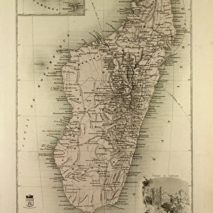
Madagascar strategic island by G. H. Davis
Madagascar, the strategic island to Allied communications in the East, occupied by British forces, forestalls a Japanese plot during the Second World War. At the time, Madagascar belonged to Vichy France. Date: 1942
Mary Evans Picture Library makes available wonderful images created for people to enjoy over the centuries
Media ID 14133295
© Illustrated London News Ltd/Mary Evans
1942 Allied Allies Davis Foil Forces Madagascar Maps Occupation Occupied Plot Route Routes Strategic Strategy Territory Vichy Foils
Photo Mug
Introducing the Media Storehouse Photo Mug, featuring the captivating image "Madagascar Strategic Island by G. H. Davis." This classic photograph, sourced from Mary Evans Prints Online, transports you back in time to the pivotal moment during the Second World War when Madagascar, a strategic island in the Indian Ocean, was occupied by British forces. The image vividly portrays the significance of the island in Allied communications, thwarting a Japanese plot. Relive history with every sip from this high-quality mug, perfect for tea or coffee. Embrace the blend of history and convenience, making it an excellent gift for history enthusiasts or as a personal addition to your collection.
A personalised photo mug blends sentimentality with functionality, making an ideal gift for cherished loved ones, close friends, or valued colleagues. Preview may show both sides of the same mug.
Elevate your coffee or tea experience with our premium white ceramic mug. Its wide, comfortable handle makes drinking easy, and you can rely on it to be both microwave and dishwasher safe. Sold in single units, preview may show both sides of the same mug so you can see how the picture wraps around.
Mug Size is 9.6cm high x 8.1cm diameter (3.8" x 3.2")
These are individually made so all sizes are approximate
EDITORS COMMENTS
Madagascar: The Strategic Island that Foiled Japanese Plots during World War II This photograph, taken by renowned photojournalist G.H. Davis in 1942, showcases a map of Madagascar, highlighting its strategic importance during the Second World War. At the time, Madagascar was under the control of Vichy France, but its significance extended far beyond its political affiliations. The island of Madagascar, located off the eastern coast of Africa, was a crucial communications hub for the Allied forces during the war. The map reveals the various routes and connections that made Madagascar an essential link in the Allied network, particularly in the East. The island's strategic position enabled the Allies to intercept and disrupt Japanese communications, thereby forestalling a potential Japanese plot to seize the island and gain a significant advantage in the war. British forces occupied Madagascar in May 1942, just months after the attack on Pearl Harbor, to secure this vital communications hub. The occupation of Madagascar was a pivotal moment in the war, as it prevented the Japanese from gaining a foothold in the Indian Ocean and disrupting Allied supply lines. This photograph is a testament to the historical significance of Madagascar during the Second World War and the role it played in foiling Japanese plans. The intricate details of the map reveal the complex web of communications and routes that made Madagascar a strategic prize worth fighting for. This image is an essential addition to any collection of historical maps or World War II memorabilia.
MADE IN AUSTRALIA
Safe Shipping with 30 Day Money Back Guarantee
FREE PERSONALISATION*
We are proud to offer a range of customisation features including Personalised Captions, Color Filters and Picture Zoom Tools
SECURE PAYMENTS
We happily accept a wide range of payment options so you can pay for the things you need in the way that is most convenient for you
* Options may vary by product and licensing agreement. Zoomed Pictures can be adjusted in the Cart.