Photo Mug > North Wind Picture Archives > Maps
Photo Mug : Cape Verde Islands map


![]()
Home Decor from North Wind
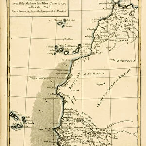
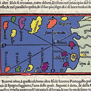
Cape Verde Islands map
Map of the Cape Verde Islands in the Atlantic.
Hand-colored woodcut of a 19th-century illustration
North Wind Picture Archives brings history to life with stock images and hand-colored illustrations
Media ID 5882578
© North Wind Picture Archives
Atlantic Atlantic Ocean Colonial Colony Exploration Maritime Ocean Portuguese Cape Verde Cape Verde Islands Portuguese Colony Saint Vincent
Photo Mug
Add a touch of adventure to your daily routine with our Media Storehouse Photo Mugs. Featuring the stunning Cape Verde Islands map from North Wind Picture Archives, these mugs showcase the rich history and beauty of this Atlantic archipelago. Hand-colored woodcut illustrations from the 19th century bring the islands to life, making each sip a journey to the heart of the sea. Perfect for travel enthusiasts, cartography lovers, or anyone who appreciates the art of storytelling through images. Make your coffee or tea break an exciting adventure with a Media Storehouse Photo Mug.
A personalised photo mug blends sentimentality with functionality, making an ideal gift for cherished loved ones, close friends, or valued colleagues. Preview may show both sides of the same mug.
Elevate your coffee or tea experience with our premium white ceramic mug. Its wide, comfortable handle makes drinking easy, and you can rely on it to be both microwave and dishwasher safe. Sold in single units, preview may show both sides of the same mug so you can see how the picture wraps around.
Mug Size is 8.1cm high x 9.6cm diameter (3.2" x 3.8")
These are individually made so all sizes are approximate
EDITORS COMMENTS
This vintage print showcases the rich history and maritime heritage of the Cape Verde Islands in the Atlantic Ocean. The hand-colored woodcut, dating back to the 19th century, offers a glimpse into the exploration and colonial era of this Portuguese colony. The map beautifully depicts the archipelago's intricate geography, with its lush landscapes and pristine coastlines. Each stroke of color brings to life the islands' unique charm and cultural significance. From Cape Verde's main island to Saint Vincent, every detail is meticulously portrayed. As we gaze upon this historic illustration, we are transported back in time when seafarers embarked on daring voyages across these vast waters. It serves as a reminder of mankind's relentless pursuit of discovery and adventure. Beyond its aesthetic appeal, this artwork holds immense value for historians and enthusiasts alike who seek to unravel the mysteries that lie within these islands' past. It invites us to delve deeper into their intriguing story – from their early settlement by Portuguese explorers to their role as vital ports along major trade routes. This remarkable piece not only captures an important chapter in our collective history but also celebrates Cape Verde's enduring legacy as a melting pot of cultures influenced by centuries of maritime exchange. Its presence on your wall will undoubtedly spark conversations about art, exploration, and our shared human journey through time.
MADE IN AUSTRALIA
Safe Shipping with 30 Day Money Back Guarantee
FREE PERSONALISATION*
We are proud to offer a range of customisation features including Personalised Captions, Color Filters and Picture Zoom Tools
SECURE PAYMENTS
We happily accept a wide range of payment options so you can pay for the things you need in the way that is most convenient for you
* Options may vary by product and licensing agreement. Zoomed Pictures can be adjusted in the Cart.