Photo Mug > Sheffield City Archives > Maps and Plans > Sheffield OS maps
Photo Mug : Ordnance Survey Map, Somerset Street area, Burngreave, Sheffield, 1889 (Yorkshire sheet no. 294. 4. 22)
")
")

![]()
Home Decor from Sheffield City Archives
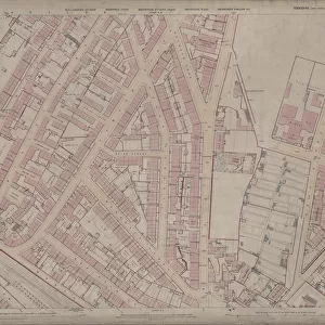
Ordnance Survey Map, Somerset Street area, Burngreave, Sheffield, 1889 (Yorkshire sheet no. 294. 4. 22)
This map features:
Top left: Rock Street, Nottingham Street, Brackley Street, Somerset Road, Catherine Street, Somerset Street, Leicester Villas, Fox Street, Cranworth Road, Brotherton Street, Cliff Rise, Recreation Ground, Farm Bank, Augusta Villas, Cranworth Place, Britannia Villas, Crossby Place, Elgin Place, Oakley House, Marchmount House, Douglas Villas, Princess Villas, Kingston Villas.
Top right: Somerset Road, Catherine Street, Somerset Street, Kilton Hill, Burngreave Road, Richmond Street, Burngreave Road Police Station, Rutland Villas, Somerset View, Catherine Road, Burngreave Bank, Bressingham Road, Burngreave Street, Sandon Villas, Somerset Villas, Arundel Villas, Portland Villas, Storth Villas, Ditchingham Road, Kingston Villas.
Bottom left: Rock Street, Nottingham Street, Brackley Street, Somerset Road, Leicester Villas, Montfort Road, Andover Street, West Andover Street, Lopham Street, Rock Lane, [Andover Street Methodist Church] Methodist New Connexion Chapel (junction of Nottingham Street and Andover Street), Sunday School, Hope Villa, Nottingham Terrace, Post Office, Rock House, Clarendon Place, Beech Villas, Arundel Terrace, Helen Terrace, Fitzalan Street, Verdon Street, Manor View, Rock House, Clifton Villa, Russell Place, Palmerston Place, Blenkarn Place.
Bottom right: Andover Street, Lopham Street, Kilton Hill, Burngreave Road, Richmond Street, Police Station, Rutland Villas, Somerset View, Somerset House, [St, Catherine s] School (Boys & Girls), Andover Street, Playground, St. Catherines R.C. Church Presbytery, Montfort Street, Bramber Street, Stockton Street, Kilton Street, Kilton Lane, Brunswick Road, West Riding Police Station, Andover Street, Leamington Villa, Mona Villas, Hornby Place.
Dimensions of original: 77 x 102 cm.
Scale 10.56 feet : 1 mile [1:500].
From an original at Sheffield Libraries: q00044 (sheet no.
294.4.22)
Sheffield City Archives and Local Studies Library has an unrivalled collection of images of Sheffield, England
Media ID 24220821
© Sheffield City Council - All Rights Reserved
Burngreave Old Map Os Maps Sheffield Yorkshire
Photo Mug
Step back in time with our unique Media Storehouse Photo Mug, featuring an intriguing snapshot of history. This mug showcases an Ordnance Survey Map of the Somerset Street area in Burngreave, Sheffield, as it looked in 1889. With details of notable streets such as Rock Street, Nottingham Street, Brackley Street, and Somerset Road, this map is a captivating piece of Yorkshire's history (Sheet no. 294. 4. 22). Bring a touch of the past to your daily routine as you enjoy your favorite beverage from this beautifully designed, high-quality mug. Perfect for history enthusiasts and those who appreciate the charm of vintage maps.
A personalised photo mug blends sentimentality with functionality, making an ideal gift for cherished loved ones, close friends, or valued colleagues. Preview may show both sides of the same mug.
Elevate your coffee or tea experience with our premium white ceramic mug. Its wide, comfortable handle makes drinking easy, and you can rely on it to be both microwave and dishwasher safe. Sold in single units, preview may show both sides of the same mug so you can see how the picture wraps around.
Mug Size is 8.1cm high x 9.6cm diameter (3.2" x 3.8")
These are individually made so all sizes are approximate
EDITORS COMMENTS
This print showcases an Ordnance Survey Map of the Somerset Street area in Burngreave, Sheffield from 1889. The map, known as Yorkshire sheet no. 294.4.22, provides a detailed depiction of the neighborhood during that time. The top left section of the map reveals a bustling residential area with streets like Rock Street, Nottingham Street, and Brackley Street lined with charming Leicester Villas and Britannia Villas. Adjacent to these are recreational spots such as Cliff Rise and the Recreation Ground, offering residents ample opportunities for leisurely activities. Moving to the top right corner, we discover more landmarks including Burngreave Road Police Station and Storth Villas along Somerset Road and Catherine Street. This part of town also features notable places like Sandon Villas and Portland Villas. As we shift our attention to the bottom left portion of the map, we encounter Rock Lane leading up to Andover Street Methodist Church (also referred to as Methodist New Connexion Chapel). Other points of interest include Clarendon Place, Beech Villas, Fitzalan Street, Manor View, Russell Place among others. Finally reaching the bottom right quadrant unveils Kilton Hill overlooking Burngreave Road where West Riding Police Station stands tall alongside Leamington Villa and Mona Villas. With dimensions measuring 77 x 102 cm and a scale ratio of 10.56 feet : 1 mile [1:500], this historical artifact offers us a glimpse into Sheffield's past through its intricate details captured on this original document held at Sheffield Libraries under reference q00044 (sheet no. 294.4.22).
MADE IN AUSTRALIA
Safe Shipping with 30 Day Money Back Guarantee
FREE PERSONALISATION*
We are proud to offer a range of customisation features including Personalised Captions, Color Filters and Picture Zoom Tools
SECURE PAYMENTS
We happily accept a wide range of payment options so you can pay for the things you need in the way that is most convenient for you
* Options may vary by product and licensing agreement. Zoomed Pictures can be adjusted in the Cart.


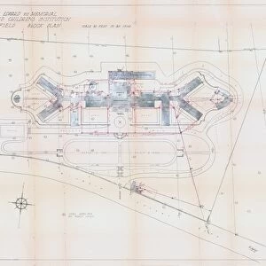

![A map of the lands near Attercliffe and Darnall, [?1820s]](/sq/716/map-lands-near-attercliffe-darnall-1820s-18396317.jpg.webp)