Photographic Print > Maps and Charts > Early Maps
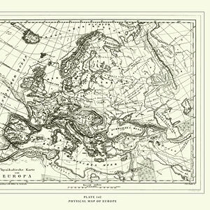
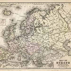
Photographic Print : A 1930s Map Of Europe


![]()
Photo Prints from Design Pics
A 1930s Map Of Europe
Design Pics offers Distinctively Different Imagery representing over 1,500 contributors
Media ID 18176902
© Hilary Jane Morgan / Design Pics
1930s 20th Countries Geographical Geography Nineteen Thirties Twentieth
15"x10" (37.5x25cm) Poster
Step back in time with our exquisite 'A 1930s Map of Europe' photographic print from Hilary Jane Morgan at Media Storehouse. This vintage map transports you to an era of history filled with intrigue and adventure. The intricate details and authentic colors bring the past to life, making it a captivating addition to any wall. Ideal for history enthusiasts, world travelers, or those who appreciate the charm of bygone eras, this print is sure to inspire conversation and spark curiosity. Order now and let the past come alive in your home or office.
High-quality poster prints are available in a range of sizes and are printed on 270 gsm semi-glossy silk finish poster paper. An affordable option for decorating any space, they are perfect for fixing straight onto walls. To ensure your poster arrives in good condition, we roll and send them in strong mailing tubes.
Our Photo Prints are in a large range of sizes and are printed on Archival Quality Paper for excellent colour reproduction and longevity. They are ideal for framing (our Framed Prints use these) at a reasonable cost. Alternatives include cheaper Poster Prints and higher quality Fine Art Paper, the choice of which is largely dependant on your budget.
Estimated Image Size (if not cropped) is 37.5cm x 24.4cm (14.8" x 9.6")
Estimated Product Size is 37.5cm x 25cm (14.8" x 9.8")
These are individually made so all sizes are approximate
Artwork printed orientated as per the preview above, with landscape (horizontal) orientation to match the source image.
FEATURES IN THESE COLLECTIONS
> Design Pics
> Design Pics Art
> Art llustrations and Engravings
> Maps and Charts
> Early Maps
> Maps and Charts
> Related Images
EDITORS COMMENTS
This print showcases a remarkable piece of history - a 1930s map of Europe meticulously crafted by the talented Hilary Jane Morgan. With its intricate details and vintage charm, this illustration takes us back to the early 20th century, offering a glimpse into European geography during that era. As we gaze upon this historical gem, our eyes are immediately drawn to the various countries that make up the continent. Each border is delicately outlined, highlighting the diverse nations that existed at that time. From bustling cities to serene countryside landscapes, this map captures Europe's rich tapestry of cultures and traditions. The artist's attention to detail is truly commendable; every river, mountain range, and coastline has been intricately depicted with precision. This stunning visual representation not only serves as an educational tool but also evokes nostalgia for a bygone era when borders were different and geopolitical dynamics were rapidly evolving. Whether you're an avid historian or simply appreciate artistry in its purest form, this 1930s Map of Europe will undoubtedly captivate your imagination. Hang it on your wall or display it proudly in your study – let it transport you back in time while igniting curiosity about how our world has transformed over the decades. Hilary Jane Morgan's masterpiece reminds us of the power maps hold in telling stories about our past and shaping our understanding of the present.
MADE IN AUSTRALIA
Safe Shipping with 30 Day Money Back Guarantee
FREE PERSONALISATION*
We are proud to offer a range of customisation features including Personalised Captions, Color Filters and Picture Zoom Tools
SECURE PAYMENTS
We happily accept a wide range of payment options so you can pay for the things you need in the way that is most convenient for you
* Options may vary by product and licensing agreement. Zoomed Pictures can be adjusted in the Cart.