Photographic Print > South America > Peru > Maps
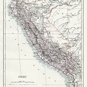
Photographic Print : Map Of ChilA©And Southern Peru To Cape Horn, Circa. 1760. From "Atlas De Toutes Les Parties Connues Du Globe Terrestre "By Cartographer Rigobert Bonne. Published Geneva Circa. 1760

![]()
Photo Prints from Design Pics
Map Of ChilA©And Southern Peru To Cape Horn, Circa. 1760. From "Atlas De Toutes Les Parties Connues Du Globe Terrestre "By Cartographer Rigobert Bonne. Published Geneva Circa. 1760
Map Of ChileAnd Southern Peru To Cape Horn, Circa.1760. From " Atlas De Toutes Les Parties Connues Du Globe Terrestre " By Cartographer Rigobert Bonne. Published Geneva Circa. 1760
Design Pics offers Distinctively Different Imagery representing over 1,500 contributors
Media ID 18186390
© Ken Welsh / Design Pics
Cape Cartography Geography Horn Mapmaking Peru Plate Southern
15"x10" (37.5x25cm) Poster
"Step back in time with our captivating vintage map print from Media Storehouse. This exquisite antique map, originally published circa 1760 in Geneva by renowned cartographer Rigobert Bonne, showcases the intricate detail of the world as it was known during that era. The Map of Chile and Southern Peru to Cape Horn is an essential addition to any decor, transporting you to the age of exploration. Bring history into your home with this beautiful, museum-quality print."
High-quality poster prints are available in a range of sizes and are printed on 270 gsm semi-glossy silk finish poster paper. An affordable option for decorating any space, they are perfect for fixing straight onto walls. To ensure your poster arrives in good condition, we roll and send them in strong mailing tubes.
Our Photo Prints are in a large range of sizes and are printed on Archival Quality Paper for excellent colour reproduction and longevity. They are ideal for framing (our Framed Prints use these) at a reasonable cost. Alternatives include cheaper Poster Prints and higher quality Fine Art Paper, the choice of which is largely dependant on your budget.
Estimated Product Size is 25cm x 37.5cm (9.8" x 14.8")
These are individually made so all sizes are approximate
Artwork printed orientated as per the preview above, with landscape (horizontal) or portrait (vertical) orientation to match the source image.
FEATURES IN THESE COLLECTIONS
> Maps and Charts
> Related Images
> South America
> Peru
> Maps
> South America
> Peru
> Related Images
EDITORS COMMENTS
This print showcases a rare and exquisite map from the 18th century. Entitled "Map Of Chile And Southern Peru To Cape Horn, Circa. 1760" this piece is a true testament to the artistry and precision of cartographer Rigobert Bonne. Published in Geneva around 1760 as part of his renowned work "Atlas De Toutes Les Parties Connues Du Globe Terrestre" this map offers a glimpse into the geographic knowledge of that era. The intricate details and vibrant colors bring to life the vast territories encompassing southern Peru, Chile, and even extending down to Cape Horn. The engraving technique used in creating this map adds depth and texture, making it an impressive visual representation of its time. Its vertical orientation allows for easy navigation through various regions while exploring their geographical features. Ken Welsh's expert photography captures every nuance of this historical artifact, preserving its beauty for generations to come. It serves as a reminder of how cartography played a crucial role in expanding our understanding of the world during an age when exploration was at its peak. Whether you are an avid collector or simply appreciate fine craftsmanship, this print is sure to captivate your imagination with its rich history and timeless appeal.
MADE IN AUSTRALIA
Safe Shipping with 30 Day Money Back Guarantee
FREE PERSONALISATION*
We are proud to offer a range of customisation features including Personalised Captions, Color Filters and Picture Zoom Tools
SECURE PAYMENTS
We happily accept a wide range of payment options so you can pay for the things you need in the way that is most convenient for you
* Options may vary by product and licensing agreement. Zoomed Pictures can be adjusted in the Cart.