Photographic Print > Europe > Related Images
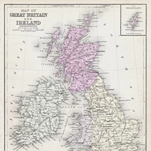
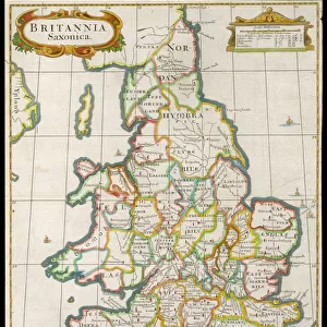
Photographic Print : England and Wales map 1875


![]()
Photo Prints from Fine Art Storehouse
England and Wales map 1875
The Independent Course Comprehensive Geography by James Monteith, A.S. Barnes & Co, New York & Chicago 1875
Unleash your creativity and transform your space into a visual masterpiece!
THEPALMER
Media ID 13612251
© This content is subject to copyright
Globe Navigational Equipment Paper Wales
10"x8" (25x20cm) Photo Print
Introducing the exquisite England and Wales Map 1875 print from our Media Storehouse range of Photographic Prints. This stunning vintage map, sourced from The Independent Course in Comprehensive Geography by James Monteith published by A.S. Barnes & Co, New York & Chicago in 1875, offers a captivating glimpse into the historical geography of England and Wales. Crafted with meticulous attention to detail, this vintage map print showcases the intricate border designs and cartographic features of the time, making it a must-have for history enthusiasts, geography scholars, and collectors. The muted tones and subtle wear add to the authenticity and charm of this unique piece, transporting you back in time. Display the England and Wales Map 1875 print in your home, office, or study to add an air of sophistication and intrigue. This is not just a map, but a window into the past that will spark conversations and inspire curiosity. Order yours today and bring a piece of historical cartography into your world.
Ideal for framing, Australian made Photo Prints are produced on high-quality 270 gsm lustre photo paper which has a subtle shimmer adding a touch of elegance, designed to enhance their visual appeal.
Our Photo Prints are in a large range of sizes and are printed on Archival Quality Paper for excellent colour reproduction and longevity. They are ideal for framing (our Framed Prints use these) at a reasonable cost. Alternatives include cheaper Poster Prints and higher quality Fine Art Paper, the choice of which is largely dependant on your budget.
Estimated Product Size is 20.3cm x 25.4cm (8" x 10")
These are individually made so all sizes are approximate
Artwork printed orientated as per the preview above, with landscape (horizontal) or portrait (vertical) orientation to match the source image.
FEATURES IN THESE COLLECTIONS
> Fine Art Storehouse
> The Magical World of Illustration
> Palmer Illustrated Collection
> Fine Art Storehouse
> Map
> Historical Maps
> Fine Art Storehouse
> Map
> USA Maps
> Europe
> Related Images
> Europe
> United Kingdom
> England
> Maps
> Europe
> United Kingdom
> England
> Posters
> Europe
> United Kingdom
> England
> Related Images
> Europe
> United Kingdom
> England
> York
> Europe
> United Kingdom
> Maps
> Europe
> United Kingdom
> Wales
> Maps
> Europe
> United Kingdom
> Wales
> Posters
> Europe
> United Kingdom
> Wales
> Related Images
> Maps and Charts
> Related Images
EDITORS COMMENTS
This print showcases a remarkable piece of history, the "England and Wales map 1875" from James Monteith's renowned publication, "The Independent Course Comprehensive Geography". Published by A. S. Barnes & Co in New York and Chicago in 1875, this antique engraving provides a fascinating glimpse into the cartography of that era. The intricately detailed illustration captures the physical geography of England and Wales with utmost precision. Every contour, river, mountain range, and city is meticulously etched onto paper to create an exquisite visual representation. The craftsmanship involved in creating this engraved image is truly commendable. As we gaze upon this vertical masterpiece, our eyes are drawn to the fine details that bring these lands to life. The delicate lines depict not only geographical features but also evoke a sense of nostalgia for a time long gone. This vintage map serves as a window into the past when navigational equipment was still evolving and globe exploration was at its peak. "The Independent Course Comprehensive Geography" holds immense historical significance as it played an instrumental role in educating generations about the world around them during its time. Now preserved through this stunning print by THEPALMER from Fine Art Storehouse, it allows us to appreciate both its artistic beauty and educational value. Whether you have an affinity for old-world charm or simply admire intricate cartography, this enchanting artwork transports you back to 1875 England and Wales while serving as a testament to human curiosity and exploration throughout history.
MADE IN AUSTRALIA
Safe Shipping with 30 Day Money Back Guarantee
FREE PERSONALISATION*
We are proud to offer a range of customisation features including Personalised Captions, Color Filters and Picture Zoom Tools
SECURE PAYMENTS
We happily accept a wide range of payment options so you can pay for the things you need in the way that is most convenient for you
* Options may vary by product and licensing agreement. Zoomed Pictures can be adjusted in the Cart.