Photographic Print > Fine Art Storehouse > Map
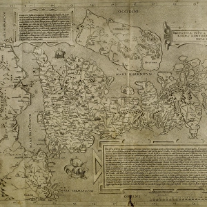
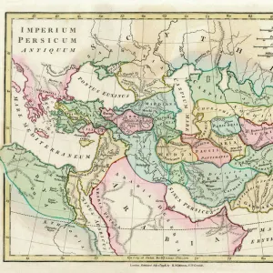
Photographic Print : Distorted antique map of Africa


![]()
Photo Prints from Fine Art Storehouse
Distorted antique map of Africa
Unleash your creativity and transform your space into a visual masterpiece!
Hemera Technologies
Media ID 13667371
© Getty Images
16th Century 16th Century Style African Animal Likeness Animal Representation Arabia Atlantic Atlantic Ocean Cartouche Continent Distorted Distorted Image Document Egypt Elephant Geography German Culture Human Likeness Human Representation Indian Ocean Lakes Legend Libya Munster Nubia Ornamental Ornate Red Sea Rivers Ship Ships Syria Text Title Words Distortion
10"x8" (25x20cm) Photo Print
Transport yourself back in time with our captivating Distorted Antique Map of Africa print from the Media Storehouse Fine Art collection. This intriguing piece, brought to you by Hemera Technologies, showcases an aged map of the African continent with intentional distortions that add a unique and alluring twist. The vintage aesthetic, with its frayed edges and worn texture, transports you to another era. Hang this beautiful work of art in your home or office to spark curiosity and ignite meaningful conversations. Elevate your decor with a touch of history and mystery from the Media Storehouse Fine Art collection.
Ideal for framing, Australian made Photo Prints are produced on high-quality 270 gsm lustre photo paper which has a subtle shimmer adding a touch of elegance, designed to enhance their visual appeal.
Our Photo Prints are in a large range of sizes and are printed on Archival Quality Paper for excellent colour reproduction and longevity. They are ideal for framing (our Framed Prints use these) at a reasonable cost. Alternatives include cheaper Poster Prints and higher quality Fine Art Paper, the choice of which is largely dependant on your budget.
Estimated Product Size is 25.4cm x 20.3cm (10" x 8")
These are individually made so all sizes are approximate
Artwork printed orientated as per the preview above, with landscape (horizontal) or portrait (vertical) orientation to match the source image.
FEATURES IN THESE COLLECTIONS
> Fine Art Storehouse
> Map
> Historical Maps
EDITORS COMMENTS
This print showcases a distorted antique map of Africa, dating back to the 16th century. The rich historical significance and intricate details make it a true masterpiece of cartography. Created by Hemera Technologies, this image captures the essence of ancient African geography with its depiction of rivers, mountains, lakes, and even animal likenesses. The ornate woodcut engraving features an array of vibrant colors that bring life to the vintage artwork. The map's cartouche proudly displays its title and key, providing valuable information for navigation in times long past. As you explore this piece further, you'll notice references to Arabian lands and Indian Ocean routes that were crucial during those times. The inclusion of human likeness adds a touch of cultural representation to this remarkable piece. It serves as a reminder not only of Africa's physical geography but also its diverse population throughout history. With no people present in the image itself, one can fully immerse themselves in the beauty and complexity of this historic artifact. Whether you are an avid collector or simply appreciate art with a historical flair, this distorted antique map is sure to captivate your imagination and transport you back centuries into Africa's fascinating past.
MADE IN AUSTRALIA
Safe Shipping with 30 Day Money Back Guarantee
FREE PERSONALISATION*
We are proud to offer a range of customisation features including Personalised Captions, Color Filters and Picture Zoom Tools
SECURE PAYMENTS
We happily accept a wide range of payment options so you can pay for the things you need in the way that is most convenient for you
* Options may vary by product and licensing agreement. Zoomed Pictures can be adjusted in the Cart.