Photographic Print > North America > United States of America > New York > New York > Maps
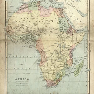
Photographic Print : Map of Africa 1883


![]()
Photo Prints from Fine Art Storehouse
Map of Africa 1883
The Eclectic Elementary Geography by Van Antwerp, Bragg & C0 / Cincinnati -New York 1883
Unleash your creativity and transform your space into a visual masterpiece!
THEPALMER
Media ID 18357175
10"x8" (25x20cm) Photo Print
Step back in time with our exquisite 'Map of Africa 1883' photographic print from The Palmer Collection at Media Storehouse. This fine art piece, sourced from the pages of 'The Eclectic Elementary Geography' by Van Antwerp, Bragg & Co., transports you to a bygone era. The intricate details of the map show Africa as it was known in 1883, offering a unique historical perspective. Perfect for adding a touch of vintage charm to your home or office, this high-quality print is a must-have for history enthusiasts, geography buffs, or anyone who appreciates the beauty of historical cartography.
Ideal for framing, Australian made Photo Prints are produced on high-quality 270 gsm lustre photo paper which has a subtle shimmer adding a touch of elegance, designed to enhance their visual appeal.
Our Photo Prints are in a large range of sizes and are printed on Archival Quality Paper for excellent colour reproduction and longevity. They are ideal for framing (our Framed Prints use these) at a reasonable cost. Alternatives include cheaper Poster Prints and higher quality Fine Art Paper, the choice of which is largely dependant on your budget.
Estimated Product Size is 20.3cm x 25.4cm (8" x 10")
These are individually made so all sizes are approximate
Artwork printed orientated as per the preview above, with landscape (horizontal) or portrait (vertical) orientation to match the source image.
FEATURES IN THESE COLLECTIONS
> Fine Art Storehouse
> Map
> Historical Maps
> Africa
> Related Images
> Maps and Charts
> Related Images
> North America
> United States of America
> New York
> New York
> Maps
> North America
> United States of America
> New York
> Related Images
EDITORS COMMENTS
This print showcases a historical treasure, the "Map of Africa 1883" taken from "The Eclectic Elementary Geography" by Van Antwerp, Bragg & Co. in Cincinnati and New York back in 1883. The map is a testament to the intricate artistry and meticulous attention to detail prevalent during that era. As we gaze upon this vintage masterpiece, we are transported back in time to an age where exploration and discovery were at their peak. The map's rich colors and delicate lines depict the vast continent of Africa with remarkable accuracy for its time. It serves as a window into an era when cartography was both science and art. Every inch of this magnificent piece tells a story - from the rivers snaking through dense jungles to mountain ranges majestically rising above arid plains. It evokes a sense of wonder about the uncharted territories that awaited intrepid explorers who dared venture into these unknown lands. "The Map of Africa 1883" is not just an educational tool but also a work of art that captures our imagination. Its presence on display adds depth and character to any space, be it home or office, transporting us on a visual journey through history. Courtesy of THEPALMER's lens, this print preserves every nuance and detail with utmost precision. Whether you are an avid historian or simply appreciate fine craftsmanship, this artwork offers endless fascination for those seeking to explore the past while admiring its aesthetic beauty.
MADE IN AUSTRALIA
Safe Shipping with 30 Day Money Back Guarantee
FREE PERSONALISATION*
We are proud to offer a range of customisation features including Personalised Captions, Color Filters and Picture Zoom Tools
SECURE PAYMENTS
We happily accept a wide range of payment options so you can pay for the things you need in the way that is most convenient for you
* Options may vary by product and licensing agreement. Zoomed Pictures can be adjusted in the Cart.