Photographic Print > Arts > Contemporary art > Digital artwork > Street art
Photographic Print : CT Middlesex Clinton Vector Road Map


![]()
Photo Prints from Fine Art Storehouse
CT Middlesex Clinton Vector Road Map
CT Middlesex Clinton Vector Road Map. All source data is in the public domain. U.S. Census Bureau Census Tiger. Used Layers: areawater, linearwater, roads, rails, cousub, pointlm, uac10
Unleash your creativity and transform your space into a visual masterpiece!
Frank Ramspott
Media ID 20687485
© Frank Ramspott, all rights reserved
City Map Computer Graphic Connecticut County Digital Composite District Geographical Border Harbor Long Island Sound Middlesex Road Map Text Vector Village Clinton Digitally Generated Image Hawks Nest Indian River Madison Ridgewood
10"x8" (25x20cm) Photo Print
Discover the unique blend of art and cartography with our CT Middlesex Clinton Vector Road Map print from the Media Storehouse Fine Art collection. Created by Frank Ramspott, this stunning piece is a must-have for those who appreciate the beauty of data visualization. Each line, point, and shape represents real-world geographical information, sourced from the U.S. Census Bureau Census Tiger dataset. This vector-based map showcases roads, rails, waterways, and points of interest in a fresh, contemporary way. A captivating addition to any home or office, this print is not just a map, but a work of art that tells a story of the CT Middlesex Clinton area.
Ideal for framing, Australian made Photo Prints are produced on high-quality 270 gsm lustre photo paper which has a subtle shimmer adding a touch of elegance, designed to enhance their visual appeal.
Our Photo Prints are in a large range of sizes and are printed on Archival Quality Paper for excellent colour reproduction and longevity. They are ideal for framing (our Framed Prints use these) at a reasonable cost. Alternatives include cheaper Poster Prints and higher quality Fine Art Paper, the choice of which is largely dependant on your budget.
Estimated Product Size is 20.3cm x 25.4cm (8" x 10")
These are individually made so all sizes are approximate
Artwork printed orientated as per the preview above, with landscape (horizontal) or portrait (vertical) orientation to match the source image.
FEATURES IN THESE COLLECTIONS
> Fine Art Storehouse
> Map
> Reference Maps
> Animals
> Mammals
> Cats (Wild)
> Tiger
> Animals
> Mammals
> Muridae
> Water Mouse
> Arts
> Contemporary art
> Digital artwork
> Street art
> Arts
> Landscape paintings
> Waterfall and river artworks
> River artworks
> Arts
> Portraits
> Pop art gallery
> Street art portraits
> Arts
> Street art graffiti
> Digital art
> Digital paintings
> Europe
> United Kingdom
> England
> Middlesex
> Related Images
> Maps and Charts
> Related Images
> Popular Themes
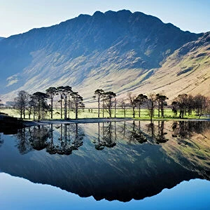
> Lake District
EDITORS COMMENTS
This print showcases the intricate details of the CT Middlesex Clinton Vector Road Map. With its vibrant colors and precise cartography, this digitally generated image is a testament to the artistry of map design. The absence of people allows us to fully appreciate the beauty and complexity of this visually stunning piece. The map encompasses various geographical features, including rivers, lakes, and coastlines, such as Ridgewood, Hawks Nest, Indian River, Grove Beach, and more. It also highlights important landmarks like harbors and bays along the Long Island Sound. The inclusion of text provides additional information about cities, towns, villages within Middlesex County. Created by Frank Ramspott using public domain data from the U. S. Census Bureau Census Tiger database and incorporating layers such as areawater, linearwater roads rails cousub pointlm uac10), this digital composite offers an accurate representation of Connecticut's Middlesex County road network. Whether you're a geography enthusiast or simply appreciate visually striking artwork with a touch of nostalgia for traditional road maps; this print is sure to captivate your imagination. Hang it in your home or office space to add a unique blend of artistry and functionality that will spark conversations among admirers.
MADE IN AUSTRALIA
Safe Shipping with 30 Day Money Back Guarantee
FREE PERSONALISATION*
We are proud to offer a range of customisation features including Personalised Captions, Color Filters and Picture Zoom Tools
SECURE PAYMENTS
We happily accept a wide range of payment options so you can pay for the things you need in the way that is most convenient for you
* Options may vary by product and licensing agreement. Zoomed Pictures can be adjusted in the Cart.