Photographic Print > Europe > Sweden > Maps
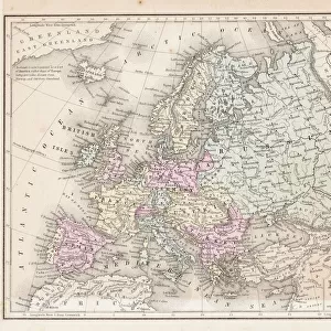
Photographic Print : Map of Narva in 1700. Artist: Mortier, Pieter (1661-1711)
")

![]()
Photo Prints from Heritage Images
Map of Narva in 1700. Artist: Mortier, Pieter (1661-1711)
Map of Narva in 1700. Private Collection
Heritage Images features heritage image collections
Media ID 15019058
© Fine Art Images
Action Baltic Sea Battle At Narva Battle Of Narva Cartography Charles Xii Charles Xii Of Sweden Fight Great Northern War Mortier Narva Peter Alexeyevich Peter I Peter I Alexeyevich Russian Army Russian Swedish War Schwedish Army Tsar Peter I
10"x8" (25x20cm) Photo Print
Step back in time with our exquisite selection from the Media Storehouse range of Historical Photographic Prints. This captivating piece showcases a meticulously detailed map of Narva in 1700, masterfully crafted by renowned artist Pieter Mortier (1661-1711). A private collection treasure, this rare and intriguing map provides a fascinating glimpse into the past, offering a unique blend of history and artistry. Perfect for enhancing any decor or starting a conversation, this high-quality print is a must-have for history enthusiasts, collectors, and those who appreciate the beauty of the past.
Ideal for framing, Australian made Photo Prints are produced on high-quality 270 gsm lustre photo paper which has a subtle shimmer adding a touch of elegance, designed to enhance their visual appeal.
Our Photo Prints are in a large range of sizes and are printed on Archival Quality Paper for excellent colour reproduction and longevity. They are ideal for framing (our Framed Prints use these) at a reasonable cost. Alternatives include cheaper Poster Prints and higher quality Fine Art Paper, the choice of which is largely dependant on your budget.
Estimated Product Size is 25.4cm x 20.3cm (10" x 8")
These are individually made so all sizes are approximate
Artwork printed orientated as per the preview above, with landscape (horizontal) or portrait (vertical) orientation to match the source image.
FEATURES IN THESE COLLECTIONS
> Europe
> Russia
> Related Images
> Europe
> Sweden
> Related Images
> Historic
> Battles
> Related Images
> Maps and Charts
> Related Images
EDITORS COMMENTS
This print showcases a remarkable piece of history - the "Map of Narva in 1700" by renowned artist Mortier, Pieter (1661-1711). This map, part of a private collection, takes us back to the intense battle and action that unfolded during the Great Northern War. The war between Russia and Sweden was at its peak as Tsar Peter I faced off against Charles XII of Sweden. The image depicts the strategic Baltic Sea region where Narva played a pivotal role. With intricate detail, Mortier's etching highlights the movements and positions of both armies - the Swedish army under Charles XII and the Russian army led by Peter I. It offers an invaluable insight into this historic clash between two powerful nations. As we delve into this visual masterpiece, we can almost feel the tension and anticipation that surrounded Narva during this fierce battle. The siege of Narva comes alive through Mortier's skilled cartography, transporting us to a time when empires clashed for dominance. This print is not just an artistic representation; it serves as a window into our past. It reminds us of significant events that shaped nations and altered history forever. Let us cherish these fine art images as they connect us with our roots and allow us to appreciate the sacrifices made by those who fought on these very grounds centuries ago.
MADE IN AUSTRALIA
Safe Shipping with 30 Day Money Back Guarantee
FREE PERSONALISATION*
We are proud to offer a range of customisation features including Personalised Captions, Color Filters and Picture Zoom Tools
SECURE PAYMENTS
We happily accept a wide range of payment options so you can pay for the things you need in the way that is most convenient for you
* Options may vary by product and licensing agreement. Zoomed Pictures can be adjusted in the Cart.