
Poster Print > Europe > France > Maps
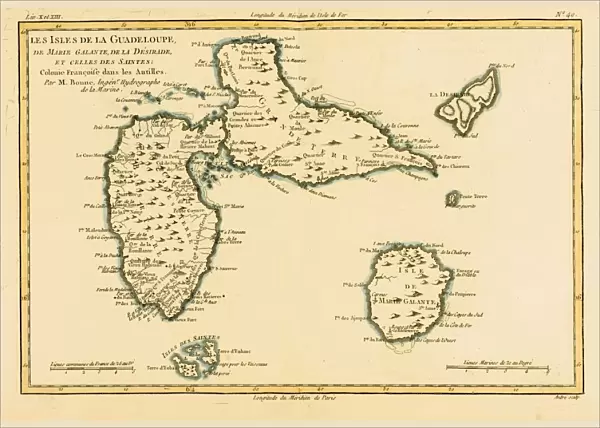
Poster Print : Map Of The French Indies Or French Caribbean Circa. 1760. From "Atlas De Toutes Les Parties Connues Du Globe Terrestre "By Cartographer Rigobert Bonne. Published Geneva Circa. 1760


![]()
Poster Prints from Design Pics
Map Of The French Indies Or French Caribbean Circa. 1760. From "Atlas De Toutes Les Parties Connues Du Globe Terrestre "By Cartographer Rigobert Bonne. Published Geneva Circa. 1760
Map Of The French Indies Or French Caribbean Circa.1760. From " Atlas De Toutes Les Parties Connues Du Globe Terrestre " By Cartographer Rigobert Bonne. Published Geneva Circa. 1760
Design Pics offers Distinctively Different Imagery representing over 1,500 contributors
Media ID 18186431
© Ken Welsh / Design Pics
Caribbean Cartography Geography Indies Mapmaking Plate
A4 (29.7 x 21cm) Poster Print
Transport yourself back in time with our vintage Map of the French Indies or French Caribbean print from the "Atlas De Toutes Les Parties Connues Du Globe Terrestre" by renowned cartographer Rigobert Bonne. Published in Geneva circa 1760, this captivating poster showcases intricate details of the French colonial territories in the Caribbean during that era. Add an authentic touch to your home or office decor with this historically significant and beautifully detailed map print, perfect for history enthusiasts and world travelers alike.
Premium quality poster prints are printed on luxurious semi-gloss satin 270 gsm paper. Our meticulously crafted poster prints offer an affordable option for decorating any space, making them ideal for living rooms, bedrooms, offices and beyond. To ensure your poster arrives in good condition, we roll and send them in strong mailing tubes.
Poster prints are budget friendly enlarged prints in standard poster paper sizes (A0, A1, A2, A3 etc). Whilst poster paper is sometimes thinner and less durable than our other paper types, they are still ok for framing and should last many years. Our Archival Quality Photo Prints and Fine Art Paper Prints are printed on higher quality paper and the choice of which largely depends on your budget.
Estimated Image Size (if not cropped) is 30.3cm x 20.8cm (11.9" x 8.2")
Estimated Product Size is 30.3cm x 21.6cm (11.9" x 8.5")
These are individually made so all sizes are approximate
Artwork printed orientated as per the preview above, with landscape (horizontal) orientation to match the source image.
FEATURES IN THESE COLLECTIONS
> Maps and Charts
> Related Images
EDITORS COMMENTS
This print showcases a historic map of the French Indies or French Caribbean, dating back to approximately 1760. The intricate details and vibrant colors bring this cartographic masterpiece to life, allowing us to delve into the rich history and geography of these tropical territories. Created by renowned cartographer Rigobert Bonne, this map is part of his esteemed work "Atlas De Toutes Les Parties Connues Du Globe Terrestre" published in Geneva during the same period. Bonne's expertise in mapmaking is evident through the precision and accuracy displayed on this horizontal engraving. The French Indies or French Caribbean region depicted on this map encompasses an array of islands, each marked with its own unique charm and allure. From Martinique to Guadeloupe, Saint Lucia to Dominica, every island is meticulously illustrated with topographical features and coastal outlines. This print not only serves as a visual delight but also offers valuable insights into the historical significance of these territories during the 18th century. It invites us to embark on a journey through time and explore how these islands played a pivotal role in trade routes, colonization efforts, and cultural exchanges between Europe and the New World. Whether you are an enthusiast of cartography or simply intrigued by the allure of exotic lands, this print will undoubtedly captivate your imagination while adding a touch of elegance to any space it graces.
MADE IN AUSTRALIA
Safe Shipping with 30 Day Money Back Guarantee
FREE PERSONALISATION*
We are proud to offer a range of customisation features including Personalised Captions, Color Filters and Picture Zoom Tools
SECURE PAYMENTS
We happily accept a wide range of payment options so you can pay for the things you need in the way that is most convenient for you
* Options may vary by product and licensing agreement. Zoomed Pictures can be adjusted in the Cart.


