Poster Print > Europe > France > Canton > Loire
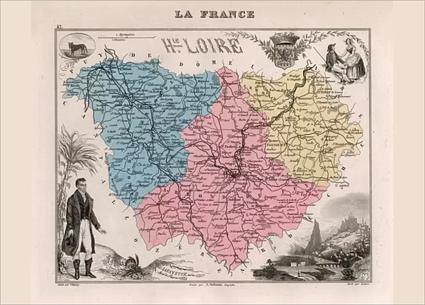
Poster Print : La Haute Loire (Haute-Loire, 43), Auvergne - France and its Colonies. Atlas illustrates one hundred and five maps from the maps of the depot of war, bridges and footwear and the Navy by M. VUILLEMIN. 1876
, Auvergne - France and its Colonies. Atlas illustrates one hundred and five maps from the maps of the depot of war, bridges and footwear and the Navy by M. VUILLEMIN. 1876")


![]()
Poster Prints from Fine Art Finder
La Haute Loire (Haute-Loire, 43), Auvergne - France and its Colonies. Atlas illustrates one hundred and five maps from the maps of the depot of war, bridges and footwear and the Navy by M. VUILLEMIN. 1876
XEE4144543 La Haute Loire (Haute-Loire, 43), Auvergne - France and its Colonies. Atlas illustrates one hundred and five maps from the maps of the depot of war, bridges and footwear and the Navy by M. VUILLEMIN. 1876. by Vuillemin, Alexandre (1812-1886); Private Collection; (add.info.: La Haute Loire (Haute-Loire, 43), Auvergne - France and its Colonies. Atlas illustrates one hundred and five maps from the maps of the depot of war, bridges and footwear and the Navy by M. VUILLEMIN. 1876.); Stefano Bianchetti; French, out of copyright
Media ID 25153700
© Stefano Bianchetti / Bridgeman Images
Atlas Book Auvergne Haute Loire 43 Geographical Map
A3 (42 x 29.7cm) Poster Print
Discover the rich history and geography of Haute-Loire, France, and its colonies with our stunning poster print from Media Storehouse. This beautiful vintage map, originally created by M. VUILLEMIN in 1876, features one hundred and five meticulously illustrated maps from the depots of war, bridges, and footwear, as well as the Navy. Transport yourself back in time with this intricately detailed and historically significant piece, perfect for adding character to any room in your home or office. By Stefano Bianchetti, from the Fine Art Finder collection.
Premium quality poster prints are printed on luxurious semi-gloss satin 270 gsm paper. Our meticulously crafted poster prints offer an affordable option for decorating any space, making them ideal for living rooms, bedrooms, offices and beyond. To ensure your poster arrives in good condition, we roll and send them in strong mailing tubes.
Poster prints are budget friendly enlarged prints in standard poster paper sizes (A0, A1, A2, A3 etc). Whilst poster paper is sometimes thinner and less durable than our other paper types, they are still ok for framing and should last many years. Our Archival Quality Photo Prints and Fine Art Paper Prints are printed on higher quality paper and the choice of which largely depends on your budget.
Estimated Product Size is 42.6cm x 30.6cm (16.8" x 12")
These are individually made so all sizes are approximate
Artwork printed orientated as per the preview above, with landscape (horizontal) orientation to match the source image.
FEATURES IN THESE COLLECTIONS
> Fine Art Finder
> Artists
> Alexandre Vuillemin
> Europe
> France
> Canton
> Loire
> Maps and Charts
> Related Images
> Services
> Royal Navy
EDITORS COMMENTS
This print showcases a historical atlas titled "La Haute Loire (Haute-Loire, 43), Auvergne - France and its Colonies". Created in 1876 by Alexandre Vuillemin, this exquisite collection features one hundred and five meticulously crafted maps sourced from the depot of war, bridges, footwear, and the Navy. The intricate details captured within these maps provide an invaluable glimpse into the geography of France during that era. The photograph highlights a particular map from the atlas that focuses on La Haute Loire region in Auvergne. With vibrant colors and precise cartographic markings, it offers a comprehensive overview of this picturesque area. From sprawling landscapes to winding rivers and charming towns, every element is intricately illustrated to transport viewers back in time. Stefano Bianchetti's expert photography captures not only the beauty of this map but also its historical significance. This image serves as a window into an era where hand-drawn maps were essential tools for navigation and exploration. Displayed against a neutral background, this print allows us to appreciate both the artistry behind Vuillemin's work and Bianchetti's skillful documentation. It is a testament to their dedication in preserving history through visual representation. Whether you are an enthusiast of cartography or simply intrigued by French history, this print provides an engaging glimpse into the past while showcasing the timeless beauty found within geographical maps.
MADE IN AUSTRALIA
Safe Shipping with 30 Day Money Back Guarantee
FREE PERSONALISATION*
We are proud to offer a range of customisation features including Personalised Captions, Color Filters and Picture Zoom Tools
SECURE PAYMENTS
We happily accept a wide range of payment options so you can pay for the things you need in the way that is most convenient for you
* Options may vary by product and licensing agreement. Zoomed Pictures can be adjusted in the Cart.