Poster Print > Asia > Iran > Lakes > Caspian Sea
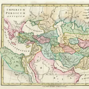
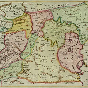
Poster Print : Antique map of Persia and the Middle East


![]()
Poster Prints from Fine Art Storehouse
Antique map of Persia and the Middle East
Unleash your creativity and transform your space into a visual masterpiece!
Hemera Technologies
Media ID 13667359
© Getty Images
Arabia Border Cartouche Cyprus Decorative Direction Document Empire Geography Holy Land Indian Ocean Iran Legend Location Mediterranean Sea Middle East Ornate Persia Persian Gulf Place Positioning Scale Turkey Turkey Middle East Caspian Persicum
A4 (29.7 x 21cm) Poster Print
Step back in time with our exquisite Antique Map of Persia and the Middle East print from the Media Storehouse Fine Art Collection. This stunning piece, brought to you by Hemera Technologies, transports you to a world of ancient history and intrigue. The intricate details of the map reveal the rich cultural heritage of the region, making it a captivating addition to any home or office space. Printed on premium quality paper, this poster is not only a beautiful work of art but also a testament to the enduring allure of cartography. Bring history to life with this unique and authentic antique map print from Media Storehouse.
Premium quality poster prints are printed on luxurious semi-gloss satin 270 gsm paper. Our meticulously crafted poster prints offer an affordable option for decorating any space, making them ideal for living rooms, bedrooms, offices and beyond. To ensure your poster arrives in good condition, we roll and send them in strong mailing tubes.
Poster prints are budget friendly enlarged prints in standard poster paper sizes (A0, A1, A2, A3 etc). Whilst poster paper is sometimes thinner and less durable than our other paper types, they are still ok for framing and should last many years. Our Archival Quality Photo Prints and Fine Art Paper Prints are printed on higher quality paper and the choice of which largely depends on your budget.
Estimated Image Size (if not cropped) is 30.3cm x 20.9cm (11.9" x 8.2")
Estimated Product Size is 30.3cm x 21.6cm (11.9" x 8.5")
These are individually made so all sizes are approximate
Artwork printed orientated as per the preview above, with landscape (horizontal) orientation to match the source image.
FEATURES IN THESE COLLECTIONS
> Fine Art Storehouse
> Map
> Historical Maps
> Arts
> Artists
> O
> Oceanic Oceanic
> Asia
> Cyprus
> Related Images
> Asia
> Iran
> Lakes
> Caspian Sea
> Asia
> Iran
> Related Images
> Asia
> Turkey
> Related Images
> Europe
> France
> Canton
> Landes
> Europe
> Related Images
> Maps and Charts
> Early Maps
EDITORS COMMENTS
This print showcases an exquisite antique map of Persia and the Middle East, meticulously crafted by Hemera Technologies. Steeped in history and brimming with intricate details, this archival piece takes us on a journey through time. The map's ornate cartouche draws our attention, adorned with delicate engravings that reflect the region's rich cultural heritage. From the Persian Gulf to the Mediterranean Sea, every border and key is thoughtfully positioned to guide us through ancient empires and holy lands. As we explore further, our eyes are drawn to significant landmarks such as Cyprus and Caspian Sea. The Indian Ocean stretches towards Arabia while Turkey stands at the crossroads between Europe and Asia. This vintage gem not only provides geographical insight but also serves as a testament to centuries-old cartography techniques. With its warm color palette and horizontal composition, this print effortlessly transports us back in time. Although devoid of people, it speaks volumes about historical events that shaped these lands. Whether you're a history enthusiast or simply appreciate fine art photography, this antique map of Persia and the Middle East will add elegance and intrigue to any space. Let it be a window into bygone eras or an invitation for wanderlust – this remarkable piece from Fine Art Storehouse is sure to captivate all who behold it.
MADE IN AUSTRALIA
Safe Shipping with 30 Day Money Back Guarantee
FREE PERSONALISATION*
We are proud to offer a range of customisation features including Personalised Captions, Color Filters and Picture Zoom Tools
SECURE PAYMENTS
We happily accept a wide range of payment options so you can pay for the things you need in the way that is most convenient for you
* Options may vary by product and licensing agreement. Zoomed Pictures can be adjusted in the Cart.