Poster Print > North America > United States of America > New York > New York > Maps
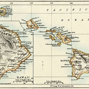
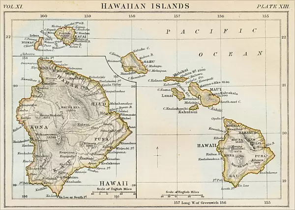
Poster Print : Map of Hawaiian islands 1883


![]()
Poster Prints from Fine Art Storehouse
Map of Hawaiian islands 1883
Encyclopedia Britannica 9th Edition New York Samuel L. Hall 1883 Vol XI
Unleash your creativity and transform your space into a visual masterpiece!
THEPALMER
Media ID 14756800
© This content is subject to copyright
A4 (29.7 x 21cm) Poster Print
"Step back in time with our exquisite 'Map of Hawaiian Islands 1883' poster print from ThePalmer at Media Storehouse. This captivating piece, taken from the Encyclopedia Britannica 9th Edition published in New York by Samuel L. Hall, showcases the Hawaiian Islands as they appeared over a century ago. Add a touch of historical charm to your walls with this beautifully detailed and intriguing map, perfect for history enthusiasts, travelers, or anyone who appreciates the beauty of vintage cartography."
Premium quality poster prints are printed on luxurious semi-gloss satin 270 gsm paper. Our meticulously crafted poster prints offer an affordable option for decorating any space, making them ideal for living rooms, bedrooms, offices and beyond. To ensure your poster arrives in good condition, we roll and send them in strong mailing tubes.
Poster prints are budget friendly enlarged prints in standard poster paper sizes (A0, A1, A2, A3 etc). Whilst poster paper is sometimes thinner and less durable than our other paper types, they are still ok for framing and should last many years. Our Archival Quality Photo Prints and Fine Art Paper Prints are printed on higher quality paper and the choice of which largely depends on your budget.
Estimated Product Size is 30.3cm x 21.6cm (11.9" x 8.5")
These are individually made so all sizes are approximate
Artwork printed orientated as per the preview above, with landscape (horizontal) or portrait (vertical) orientation to match the source image.
FEATURES IN THESE COLLECTIONS
> Fine Art Storehouse
> Map
> Historical Maps
> Arts
> Artists
> O
> Oceanic Oceanic
> Maps and Charts
> Related Images
> North America
> United States of America
> New York
> New York
> Maps
> North America
> United States of America
> New York
> Related Images
EDITORS COMMENTS
This print showcases a fascinating piece of history - the "Map of Hawaiian Islands 1883" from the Encyclopedia Britannica's 9th Edition. Published in New York by Samuel L. Hall, this remarkable map offers a glimpse into the past, transporting us to a time when Hawaii was still an independent kingdom. The intricate details and meticulous craftsmanship of this vintage map are truly awe-inspiring. Every contour and coastline is delicately etched, capturing the essence of each island - from Mauna and Oahu to Kauai - with utmost precision. The vast expanse of the Pacific Ocean serves as a stunning backdrop, reminding us of Hawaii's remote location amidst its watery surroundings. As we gaze upon this historical artifact expertly captured by THEPALMER for Fine Art Storehouse, we can't help but be transported back in time to an era when cartography was both science and art. This print not only serves as a visual delight but also acts as a window into Hawaii's rich cultural heritage. Whether you're an avid historian or simply drawn to the beauty of vintage maps, this print is sure to captivate your imagination. It invites you on an exploration through time and space while celebrating the enduring allure of one of nature's most breathtaking archipelagos – Hawaii.
MADE IN AUSTRALIA
Safe Shipping with 30 Day Money Back Guarantee
FREE PERSONALISATION*
We are proud to offer a range of customisation features including Personalised Captions, Color Filters and Picture Zoom Tools
SECURE PAYMENTS
We happily accept a wide range of payment options so you can pay for the things you need in the way that is most convenient for you
* Options may vary by product and licensing agreement. Zoomed Pictures can be adjusted in the Cart.