Poster Print > Arts > Street art graffiti > Digital art > Digital paintings
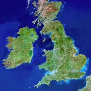
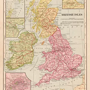
Poster Print : British Isles


![]()
Poster Prints from Fine Art Storehouse
British Isles
Satellite Maps, dv057004
Unleash your creativity and transform your space into a visual masterpiece!
Digital Vision.
Media ID 14833399
© This content is subject to copyright
A4 (29.7 x 21cm) Poster Print
Discover the breathtaking beauty of the British Isles with our exquisite Fine Art Storehouse Poster Prints. This stunning image, titled "British Isles," captured by Digital Vision, showcases the intricate satellite map detail of the region in a whole new light. Add a touch of geographical elegance to your home or office decor with this captivating and conversation-starting piece from our Media Storehouse collection. Experience the wonder of the world around you, one print at a time.
Premium quality poster prints are printed on luxurious semi-gloss satin 270 gsm paper. Our meticulously crafted poster prints offer an affordable option for decorating any space, making them ideal for living rooms, bedrooms, offices and beyond. To ensure your poster arrives in good condition, we roll and send them in strong mailing tubes.
Poster prints are budget friendly enlarged prints in standard poster paper sizes (A0, A1, A2, A3 etc). Whilst poster paper is sometimes thinner and less durable than our other paper types, they are still ok for framing and should last many years. Our Archival Quality Photo Prints and Fine Art Paper Prints are printed on higher quality paper and the choice of which largely depends on your budget.
Estimated Product Size is 21.6cm x 30.3cm (8.5" x 11.9")
These are individually made so all sizes are approximate
Artwork printed orientated as per the preview above, with landscape (horizontal) or portrait (vertical) orientation to match the source image.
FEATURES IN THESE COLLECTIONS
> Fine Art Storehouse
> Map
> Satellite Maps
> Arts
> Street art graffiti
> Digital art
> Digital paintings
> Maps and Charts
> Related Images
EDITORS COMMENTS
This photo print, titled "British Isles (Satellite Maps, dv057004)" takes us on an awe-inspiring journey above the British Isles. Captured by Digital Vision and available at Fine Art Storehouse, this remarkable artwork showcases the beauty of our planet from a unique perspective. The image presents a bird's-eye view of the British Isles, revealing their intricate coastline and diverse topography. From the rugged cliffs of Cornwall to the rolling hills of Scotland, every detail is meticulously captured in stunning clarity. The satellite mapping technique employed here allows us to appreciate the vastness and complexity of this island nation. As we gaze upon this mesmerizing composition, we are reminded of both our insignificance in comparison to nature's grandeur and our deep connection with these lands. The vibrant colors that adorn the print evoke a sense of vitality and energy inherent in these ancient landscapes. Whether you have personal ties to Britain or simply admire its rich history and natural wonders, this print serves as a visual testament to its enduring allure. Display it proudly in your home or office space as a conversation starter or as an homage to one of Earth's most enchanting regions. With "British Isles (Satellite Maps, dv057004)" adorning your walls, you can embark on countless imaginary journeys across these captivating lands without ever leaving your doorstep. Let yourself be transported into this breathtaking realm where land meets sea and history intertwines with modernity – all through the lens of Digital Vision's artistry.
MADE IN AUSTRALIA
Safe Shipping with 30 Day Money Back Guarantee
FREE PERSONALISATION*
We are proud to offer a range of customisation features including Personalised Captions, Color Filters and Picture Zoom Tools
SECURE PAYMENTS
We happily accept a wide range of payment options so you can pay for the things you need in the way that is most convenient for you
* Options may vary by product and licensing agreement. Zoomed Pictures can be adjusted in the Cart.